


legrand serre

whisper73
User
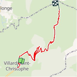

Length
8 km

Max alt
2126 m

Uphill gradient
1191 m
Km-Effort
20 km

Min alt
1060 m

Downhill gradient
126 m
Boucle
No
Creation date :
2018-06-26 15:59:06.409
Updated on :
2018-06-26 15:59:06.409
2h27
Difficulty : Medium

FREE GPS app for hiking
 SityTrail
IGN / Geographical institutes
SityTrail Plus
The world is yours!
About
Trail Walking of 8 km to be discovered at Auvergne-Rhône-Alpes, Isère, Villard-Saint-Christophe. This trail is proposed by whisper73.
Positioning
Country:
France
Region :
Auvergne-Rhône-Alpes
Department/Province :
Isère
Municipality :
Villard-Saint-Christophe
Location:
Unknown
Start:(Dec)
Start:(UTM)
721196 ; 4984364 (31T) N.
Comments