


Gerberoy vers Songeons et retour

MichelRando7656
User
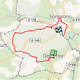

Length
7 km

Max alt
210 m

Uphill gradient
115 m
Km-Effort
8.7 km

Min alt
110 m

Downhill gradient
168 m
Boucle
No
Creation date :
2019-04-29 10:39:38.401
Updated on :
2019-04-29 10:39:38.468
1h50
Difficulty : Unknown

FREE GPS app for hiking
 SityTrail
IGN / Geographical institutes
SityTrail Plus
The world is yours!
About
Trail Walking of 7 km to be discovered at Hauts-de-France, Oise, Gerberoy. This trail is proposed by MichelRando7656.
Description
Chemins forestiers


Positioning
Country:
France
Region :
Hauts-de-France
Department/Province :
Oise
Municipality :
Gerberoy
Location:
Unknown
Start:(Dec)
Start:(UTM)
416599 ; 5487510 (31U) N.
Comments