


Randonnée Cevennes J3

raphael94
User
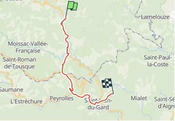

Length
18.6 km

Max alt
600 m

Uphill gradient
676 m
Km-Effort
28 km

Min alt
184 m

Downhill gradient
723 m
Boucle
No
Creation date :
2018-06-26 16:19:16.392
Updated on :
2018-06-26 16:19:16.392
5h45
Difficulty : Unknown

FREE GPS app for hiking
 SityTrail
IGN / Geographical institutes
SityTrail Plus
The world is yours!
About
Trail Walking of 18.6 km to be discovered at Occitania, Lozère, Saint-Germain-de-Calberte. This trail is proposed by raphael94.
Positioning
Country:
France
Region :
Occitania
Department/Province :
Lozère
Municipality :
Saint-Germain-de-Calberte
Location:
Unknown
Start:(Dec)
Start:(UTM)
567021 ; 4893840 (31T) N.
Comments