


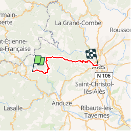
Randonnée Cevennes J4

raphael94
User

Length
21 km

Max alt
666 m

Uphill gradient
914 m
Km-Effort
34 km

Min alt
129 m

Downhill gradient
1102 m
Boucle
No
Creation date :
2018-06-26 16:19:17.158
Updated on :
2018-06-26 16:19:17.158
2h56
Difficulty : Unknown

FREE GPS app for hiking
 SityTrail
IGN / Geographical institutes
SityTrail Plus
The world is yours!
About
Trail Walking of 21 km to be discovered at Occitania, Gard, Mialet. This trail is proposed by raphael94.
Positioning
Country:
France
Region :
Occitania
Department/Province :
Gard
Municipality :
Mialet
Location:
Unknown
Start:(Dec)
Start:(UTM)
572564 ; 4885088 (31T) N.
Comments