


taillet grande boucle

gnortier
User
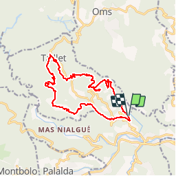

Length
17.6 km

Max alt
641 m

Uphill gradient
601 m
Km-Effort
26 km

Min alt
214 m

Downhill gradient
595 m
Boucle
Yes
Creation date :
2018-06-26 16:23:27.385
Updated on :
2018-06-26 16:23:27.385
5h11
Difficulty : Medium

FREE GPS app for hiking
 SityTrail
IGN / Geographical institutes
SityTrail Plus
The world is yours!
About
Trail Walking of 17.6 km to be discovered at Occitania, Pyrénées-Orientales, Reynès. This trail is proposed by gnortier.
Positioning
Country:
France
Region :
Occitania
Department/Province :
Pyrénées-Orientales
Municipality :
Reynès
Location:
Unknown
Start:(Dec)
Start:(UTM)
476187 ; 4705864 (31T) N.
Comments