


Chantilly - Camp de cesar 19.2 km

GOELERANDO2
User
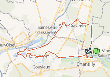

Length
19.2 km

Max alt
77 m

Uphill gradient
190 m
Km-Effort
22 km

Min alt
24 m

Downhill gradient
191 m
Boucle
Yes
Creation date :
2018-06-26 16:24:02.976
Updated on :
2018-06-26 16:24:02.976
4h47
Difficulty : Difficult

FREE GPS app for hiking
 SityTrail
IGN / Geographical institutes
SityTrail Plus
The world is yours!
About
Trail Walking of 19.2 km to be discovered at Hauts-de-France, Oise, Chantilly. This trail is proposed by GOELERANDO2.
Description
Parking et départ Av.du Bouteiller à Chantilly
Positioning
Country:
France
Region :
Hauts-de-France
Department/Province :
Oise
Municipality :
Chantilly
Location:
Unknown
Start:(Dec)
Start:(UTM)
461615 ; 5449448 (31U) N.
Comments