


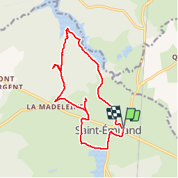
V - 2019 - 03.09 Saint Emiland (rando douce)

clabidault
User

Length
8.2 km

Max alt
472 m

Uphill gradient
98 m
Km-Effort
9.5 km

Min alt
421 m

Downhill gradient
102 m
Boucle
Yes
Creation date :
2018-06-26 16:43:30.608
Updated on :
2019-09-04 19:26:42.089
2h05
Difficulty : Easy

FREE GPS app for hiking
 SityTrail
IGN / Geographical institutes
SityTrail Plus
The world is yours!
About
Trail Walking of 8.2 km to be discovered at Bourgogne-Franche-Comté, Saône-et-Loire, Saint-Émiland. This trail is proposed by clabidault.
Description
12 Participants en 2017, 24 en 2019
Positioning
Country:
France
Region :
Bourgogne-Franche-Comté
Department/Province :
Saône-et-Loire
Municipality :
Saint-Émiland
Location:
Unknown
Start:(Dec)
Start:(UTM)
613147 ; 5195580 (31T) N.
Comments