


puy Pariou Dome

thle
User
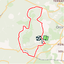

Length
16.1 km

Max alt
1138 m

Uphill gradient
358 m
Km-Effort
21 km

Min alt
868 m

Downhill gradient
357 m
Boucle
Yes
Creation date :
2018-06-26 16:43:45.99
Updated on :
2018-06-26 16:43:45.99
2h33
Difficulty : Unknown

FREE GPS app for hiking
 SityTrail
IGN / Geographical institutes
SityTrail Plus
The world is yours!
About
Trail Equestrian of 16.1 km to be discovered at Auvergne-Rhône-Alpes, Puy-de-Dôme, Orcines. This trail is proposed by thle.
Positioning
Country:
France
Region :
Auvergne-Rhône-Alpes
Department/Province :
Puy-de-Dôme
Municipality :
Orcines
Location:
Unknown
Start:(Dec)
Start:(UTM)
498805 ; 5068427 (31T) N.
Comments