


le trou à merle de Parmain

avdem
User

Length
12.3 km

Max alt
101 m

Uphill gradient
166 m
Km-Effort
14.5 km

Min alt
24 m

Downhill gradient
162 m
Boucle
No
Creation date :
2018-06-26 16:52:14.747
Updated on :
2018-06-26 16:52:14.747
3h16
Difficulty : Unknown

FREE GPS app for hiking
 SityTrail
IGN / Geographical institutes
SityTrail Plus
The world is yours!
About
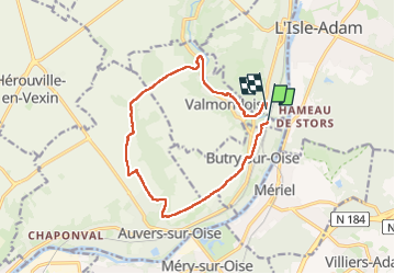
Trail Other activity of 12.3 km to be discovered at Ile-de-France, Val-d'Oise, Valmondois. This trail is proposed by avdem.
Positioning
Country:
France
Region :
Ile-de-France
Department/Province :
Val-d'Oise
Municipality :
Valmondois
Location:
Unknown
Start:(Dec)
Start:(UTM)
441807 ; 5438125 (31U) N.
Comments