


Greolieres, circuit vers Les Bouisses, vasque dans le Loup, aquaduc

elcanario
User
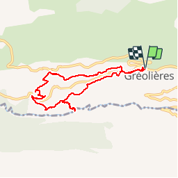

Length
7.7 km

Max alt
952 m

Uphill gradient
337 m
Km-Effort
12.2 km

Min alt
641 m

Downhill gradient
337 m
Boucle
Yes
Creation date :
2018-06-26 16:53:17.955
Updated on :
2018-06-26 16:53:17.955
3h30
Difficulty : Easy

FREE GPS app for hiking
 SityTrail
IGN / Geographical institutes
SityTrail Plus
The world is yours!
About
Trail Walking of 7.7 km to be discovered at Provence-Alpes-Côte d'Azur, Maritime Alps, Gréolières. This trail is proposed by elcanario.
Photos


Positioning
Country:
France
Region :
Provence-Alpes-Côte d'Azur
Department/Province :
Maritime Alps
Municipality :
Gréolières
Location:
Unknown
Start:(Dec)
Start:(UTM)
334492 ; 4851310 (32T) N.
Comments