


Le Rayol Canadel - St Clair

henriantoine
User
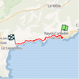

Length
16.7 km

Max alt
79 m

Uphill gradient
323 m
Km-Effort
21 km

Min alt
2 m

Downhill gradient
384 m
Boucle
No
Creation date :
2018-09-11 10:15:37.285
Updated on :
2018-09-11 10:15:37.285
5h26
Difficulty : Medium

FREE GPS app for hiking
 SityTrail
IGN / Geographical institutes
SityTrail Plus
The world is yours!
About
Trail Walking of 16.7 km to be discovered at Provence-Alpes-Côte d'Azur, Var, Rayol-Canadel-sur-Mer. This trail is proposed by henriantoine.
Photos


26 photos in total. Please click on a photo to see them all in the gallery.
Positioning
Country:
France
Region :
Provence-Alpes-Côte d'Azur
Department/Province :
Var
Municipality :
Rayol-Canadel-sur-Mer
Location:
Unknown
Start:(Dec)
Start:(UTM)
295042 ; 4781654 (32T) N.
Comments