


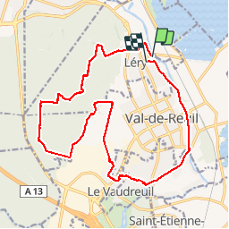
Lery, Val de Reuil, Le Vaudreuil

MichelRando7656
User

Length
19.2 km

Max alt
138 m

Uphill gradient
224 m
Km-Effort
22 km

Min alt
6 m

Downhill gradient
221 m
Boucle
No
Creation date :
2019-04-29 10:39:37.397
Updated on :
2019-04-29 10:39:37.463
3h50
Difficulty : Medium

FREE GPS app for hiking
 SityTrail
IGN / Geographical institutes
SityTrail Plus
The world is yours!
About
Trail Walking of 19.2 km to be discovered at Normandy, Eure, Léry. This trail is proposed by MichelRando7656.
Description
Chemins forestiers, traversée de ville puis joli chemin le long de l'Eure jusqu'à L'étude
Positioning
Country:
France
Region :
Normandy
Department/Province :
Eure
Municipality :
Léry
Location:
Unknown
Start:(Dec)
Start:(UTM)
369779 ; 5460921 (31U) N.
Comments