Trail Canoe - kayak Plobsheim - Canoé-Rhin Tortu - Photo

Canoé-Rhin Tortu

© OpenStreetMap contributors
Length
Length
19 km
Max alt
Max alt
151 m
Uphill gradient
Uphill gradient
126 m
Km-Effort
Km-Effort  
21 km
Min alt
Min alt
134 m
Downhill gradient
Downhill gradient
133 m
Boucle
Boucle
No
Creation date :
2018-06-26 16:58:18.0
Updated on :
2018-12-03 09:12:12.825

(0 Reviews)

Canoe - kayak
Canoe - kayak
5h00
Difficulty : Medium

Scan this QR Code to open this trail in the SityTrail application

FREE GPS app for hiking

Logo SityTrail SityTrail

IGN / Geographical institutes

Download SityTrail from the App Store Download SityTrail from Google Play

Logo SityTrail SityTrail World

The world is yours!

Download SityTrail from the App Store Download SityTrail from Google Play Download SityTrail on Huawei AppGallery

About

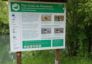
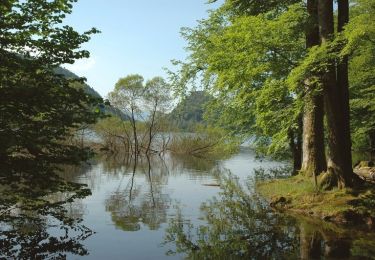
Trail Canoe - kayak of 19 km to be discovered at Grand Est, Bas-Rhin, Plobsheim. This trail is proposed by benoit747.

Description

Sécurité :
La pratique du canoé est une activité à risque.
Cette descente ne doit pas être réalisée par une personne novice en canoé-kayak
les rivières sont des milieux changeant... le parcours proposé ici peut ne pas être réalisable dans certaines conditions (niveaux d'eaux, présence d'obstacle)
Vous réalisez cette descente à vos risque et péril. Je ne peux pas garantir l'état de cette rivière au moment où vous la ferez


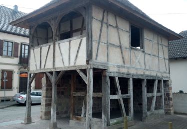
Un parcours sympa à faire en canoé.
Très sauvage sur les 2 premier tiers du parcours
zone d'embarquement et d'arrivée facile

le passage du moulin de ganzau (km 11) se fait en débarquant coté gauche et en marchant 200m

le passage de l'écluse du pont suchard (km 16.5) se fait en s'engageant dans le petit chenal à gauche et en débarquant au bout (portage 30m, zone un peu crade)

possible de faire la navette en vélo par la piste cyclable le long du canal
Possibilité d'accrocher le vélo dans le parc à l'arrivée

Elevation profile

Points of interest

Point of interest Illkirch-Graffenstaden - Moulin de Ganzau - débarquement, portage - Photo
benoit747
ILLKIRCH-GRAFFENSTADEN 
Point of interest Strasbourg - écluse pont suchard - Photo
benoit747

Positioning

Country:
France
Region :
Grand Est
Department/Province :
Bas-Rhin
Municipality :
Plobsheim
Location:
Unknown
Start:(UTM)
405815 ; 5369394 (32U) N.

Trails nearby

Trail Walking Erstein - polder sommerly Erstein  - Photo
Walking
apa

Walking

Easy
Erstein, Grand Est, Bas-Rhin, France
14.5 km | 15.7 km-effort
4h 3min
Yes
Trail Walking Nordhouse - 2023/04/23 L'Ill et l'écluse 81 par champs et forêt - Photo
Walking
Mich&Agnès

Walking

Very easy
Nordhouse, Grand Est, Bas-Rhin, France
10 km | 10.9 km-effort
1h 49min
Yes
Trail On foot Fegersheim - Tour de FEGERSHEIM OHNHEIM ESCHAU - Photo
On foot
PRO

On foot

Easy
Fegersheim, Grand Est, Bas-Rhin, France
10.3 km | 11.3 km-effort
2h 34min
Yes
Trail Walking Eschau - Le circuit des pêcheurs - Photo
Walking
VacheKiri67

Walking

Easy
(1)
Eschau, Grand Est, Bas-Rhin, France
10.9 km | 11.9 km-effort
2h 50min
Yes
Trail Mountain bike Nordhouse - Circuit entre les Ill - Photo
Mountain bike
tracegps

Mountain bike

Medium
Nordhouse, Grand Est, Bas-Rhin, France
14.4 km | 15.8 km-effort
1h 0min
Yes
Trail Electric bike Fegersheim - xc 240411 kehl oksana - Photo
Electric bike
xc

Electric bike

Very easy
Fegersheim, Grand Est, Bas-Rhin, France
37 km | 41 km-effort
3h 26min
Yes
Trail sport Illkirch-Graffenstaden - Balade piste cavalière, Illkirch  - Photo
sport
Louane KAEUFLING

sport

Very easy
Illkirch-Graffenstaden, Grand Est, Bas-Rhin, France
13.4 km | 14.6 km-effort
Unknown
Yes
Trail Walking Hipsheim - Hipsheim - Photo
Walking
Jean-Pascal Sap

Walking

Medium
Hipsheim, Grand Est, Bas-Rhin, France
11 km | 12 km-effort
2h 36min
Yes
Trail Walking Fegersheim - xc 200722  environ fegersheim hipsheim eschau - Photo
Walking
xc

Walking

Very easy
Fegersheim, Grand Est, Bas-Rhin, France
10.7 km | 11.8 km-effort
2h 11min
Yes


Close
My subscriptions