Compostelle 5 GR65

Landreger
User

Length
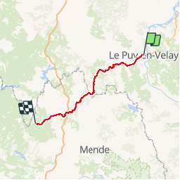
115 km

Max alt
1336 m

Uphill gradient
3074 m
Km-Effort
154 km

Min alt
592 m

Downhill gradient
2541 m
Boucle
No
Creation date :
2014-12-10 00:00:00.0
Updated on :
2014-12-10 00:00:00.0
--
Difficulty : Medium

FREE GPS app for hiking
 SityTrail
IGN / Geographical institutes
SityTrail Plus
The world is yours!
About
Trail Walking of 115 km to be discovered at Auvergne-Rhône-Alpes, Haute-Loire, Le Puy-en-Velay. This trail is proposed by Landreger.
Description
Randonnée avec le GR65, à travers la Haute-Loire et la Lozère du Puy en Velay à Nasbinals.
Positioning
Country:
France
Region :
Auvergne-Rhône-Alpes
Department/Province :
Haute-Loire
Municipality :
Le Puy-en-Velay
Location:
Unknown
Start:(Dec)
Start:(UTM)
569500 ; 4988145 (31T) N.
Comments