


Mgn.

rigol05
User
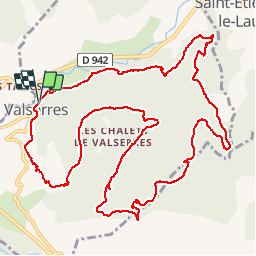

Length
15.2 km

Max alt
1404 m

Uphill gradient
867 m
Km-Effort
27 km

Min alt
677 m

Downhill gradient
867 m
Boucle
Yes
Creation date :
2018-06-26 17:14:53.486
Updated on :
2018-06-26 17:14:53.486
5h26
Difficulty : Difficult

FREE GPS app for hiking
 SityTrail
IGN / Geographical institutes
SityTrail Plus
The world is yours!
About
Trail Walking of 15.2 km to be discovered at Provence-Alpes-Côte d'Azur, Hautes-Alpes, Valserres. This trail is proposed by rigol05.
Description
Sortie du 25/06/2018
Positioning
Country:
France
Region :
Provence-Alpes-Côte d'Azur
Department/Province :
Hautes-Alpes
Municipality :
Valserres
Location:
Unknown
Start:(Dec)
Start:(UTM)
271630 ; 4930234 (32T) N.
Comments