


Chassagne 26 juin18

yakout
User
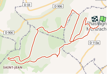

Length
14.4 km

Max alt
493 m

Uphill gradient
383 m
Km-Effort
19.5 km

Min alt
253 m

Downhill gradient
383 m
Boucle
Yes
Creation date :
2018-06-27 12:28:24.761
Updated on :
2018-06-27 12:28:24.761
4h08
Difficulty : Unknown

FREE GPS app for hiking
 SityTrail
IGN / Geographical institutes
SityTrail Plus
The world is yours!
About
Trail Walking of 14.4 km to be discovered at Bourgogne-Franche-Comté, Côte-d'Or, Chassagne-Montrachet. This trail is proposed by yakout.
Positioning
Country:
France
Region :
Bourgogne-Franche-Comté
Department/Province :
Côte-d'Or
Municipality :
Chassagne-Montrachet
Location:
Unknown
Start:(Dec)
Start:(UTM)
631494 ; 5199556 (31T) N.
Comments