


Vallées de l'Our et de la Clerve

PhilippeC54
User
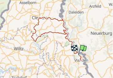

Length
77 km

Max alt
522 m

Uphill gradient
1511 m
Km-Effort
97 km

Min alt
205 m

Downhill gradient
1511 m
Boucle
Yes
Creation date :
2019-01-15 12:11:09.607
Updated on :
2019-01-15 12:11:09.607
5h33
Difficulty : Easy

FREE GPS app for hiking
 SityTrail
IGN / Geographical institutes
SityTrail Plus
The world is yours!
About
Trail Cycle of 77 km to be discovered at Unknown, Canton Vianden, Putscheid. This trail is proposed by PhilippeC54.
Positioning
Country:
Luxembourg
Region :
Unknown
Department/Province :
Canton Vianden
Municipality :
Putscheid
Location:
Unknown
Start:(Dec)
Start:(UTM)
298858 ; 5536714 (32U) N.
Comments