


180627 EnCours

randodan
User
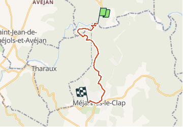

Length
8.2 km

Max alt
325 m

Uphill gradient
287 m
Km-Effort
11.3 km

Min alt
104 m

Downhill gradient
69 m
Boucle
No
Creation date :
2019-01-15 12:11:18.218
Updated on :
2019-01-15 12:11:18.218
2h50
Difficulty : Unknown

FREE GPS app for hiking
 SityTrail
IGN / Geographical institutes
SityTrail Plus
The world is yours!
About
Trail Walking of 8.2 km to be discovered at Occitania, Gard, Méjannes-le-Clap. This trail is proposed by randodan.
Description
En cours
Photos


Positioning
Country:
France
Region :
Occitania
Department/Province :
Gard
Municipality :
Méjannes-le-Clap
Location:
Unknown
Start:(Dec)
Start:(UTM)
607600 ; 4901989 (31T) N.
Comments