Ginestet

jdelettrez
User
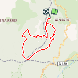

Length
7.8 km

Max alt
1090 m

Uphill gradient
258 m
Km-Effort
11.3 km

Min alt
887 m

Downhill gradient
257 m
Boucle
Yes
Creation date :
2019-01-15 12:11:57.775
Updated on :
2019-04-27 10:10:48.3
2h21
Difficulty : Easy

FREE GPS app for hiking
 SityTrail
IGN / Geographical institutes
SityTrail Plus
The world is yours!
About
Trail Walking of 7.8 km to be discovered at Occitania, Hérault, Castanet-le-Haut. This trail is proposed by jdelettrez.
Description
Randonnée en altitudepour periode de chaleur
Positioning
Country:
France
Region :
Occitania
Department/Province :
Hérault
Municipality :
Castanet-le-Haut
Location:
Unknown
Start:(Dec)
Start:(UTM)
493626 ; 4835455 (31T) N.
Comments