


SVG 180628

randodan
User
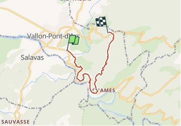

Length
10.5 km

Max alt
330 m

Uphill gradient
474 m
Km-Effort
16.3 km

Min alt
78 m

Downhill gradient
292 m
Boucle
No
Creation date :
2019-01-15 12:13:32.758
Updated on :
2019-01-15 12:13:32.758
5h48
Difficulty : Unknown

FREE GPS app for hiking
 SityTrail
IGN / Geographical institutes
SityTrail Plus
The world is yours!
About
Trail Walking of 10.5 km to be discovered at Auvergne-Rhône-Alpes, Ardèche, Vallon-Pont-d'Arc. This trail is proposed by randodan.
Photos


26 photos in total. Please click on a photo to see them all in the gallery.
Positioning
Country:
France
Region :
Auvergne-Rhône-Alpes
Department/Province :
Ardèche
Municipality :
Vallon-Pont-d'Arc
Location:
Unknown
Start:(Dec)
Start:(UTM)
611684 ; 4916955 (31T) N.
Comments