


Ajou

werth
User

Length
14.3 km

Max alt
183 m

Uphill gradient
193 m
Km-Effort
16.9 km

Min alt
127 m

Downhill gradient
196 m
Boucle
Yes
Creation date :
2019-01-15 12:15:28.958
Updated on :
2019-01-15 12:15:28.958
5h01
Difficulty : Easy

FREE GPS app for hiking
 SityTrail
IGN / Geographical institutes
SityTrail Plus
The world is yours!
About
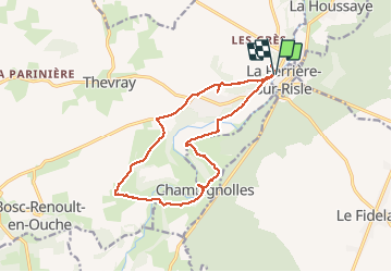
Trail Walking of 14.3 km to be discovered at Normandy, Eure, Mesnil-en-Ouche. This trail is proposed by werth.
Description
Très agréable, jolis chemins.
Photos


Positioning
Country:
France
Region :
Normandy
Department/Province :
Eure
Municipality :
Mesnil-en-Ouche
Location:
Ajou
Start:(Dec)
Start:(UTM)
337766 ; 5427490 (31U) N.
Comments