


balade Gerbier de joncs

raab
User
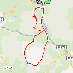

Length
8.1 km

Max alt
1456 m

Uphill gradient
144 m
Km-Effort
10 km

Min alt
1376 m

Downhill gradient
143 m
Boucle
Yes
Creation date :
2018-07-30 16:23:21.977
Updated on :
2018-07-30 16:23:21.987
2h08
Difficulty : Easy

FREE GPS app for hiking
 SityTrail
IGN / Geographical institutes
SityTrail Plus
The world is yours!
About
Trail Walking of 8.1 km to be discovered at Auvergne-Rhône-Alpes, Ardèche, Sainte-Eulalie. This trail is proposed by raab.
Positioning
Country:
France
Region :
Auvergne-Rhône-Alpes
Department/Province :
Ardèche
Municipality :
Sainte-Eulalie
Location:
Unknown
Start:(Dec)
Start:(UTM)
596956 ; 4965793 (31T) N.
Comments
Dommage la dernière partie sur la route autrement, superbe 👍