


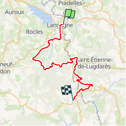
02 Langogne-BastidePuylaurent

nicolas54230
User

Length
50 km

Max alt
1250 m

Uphill gradient
1473 m
Km-Effort
69 km

Min alt
910 m

Downhill gradient
1340 m
Boucle
No
Creation date :
2019-01-15 12:32:46.908
Updated on :
2019-01-15 12:32:46.908
2h17
Difficulty : Difficult

FREE GPS app for hiking
 SityTrail
IGN / Geographical institutes
SityTrail Plus
The world is yours!
About
Trail Mountain bike of 50 km to be discovered at Occitania, Lozère, Langogne. This trail is proposed by nicolas54230.
Positioning
Country:
France
Region :
Occitania
Department/Province :
Lozère
Municipality :
Langogne
Location:
Unknown
Start:(Dec)
Start:(UTM)
568485 ; 4952935 (31T) N.
Comments