


balade Meyras le Ranc

raab
User
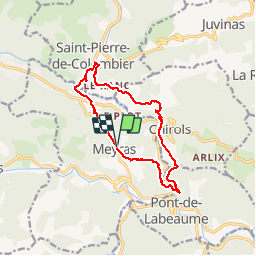

Length
13 km

Max alt
538 m

Uphill gradient
384 m
Km-Effort
18.1 km

Min alt
305 m

Downhill gradient
386 m
Boucle
Yes
Creation date :
2018-07-30 16:23:21.778
Updated on :
2018-07-30 16:23:21.787
3h54
Difficulty : Medium

FREE GPS app for hiking
 SityTrail
IGN / Geographical institutes
SityTrail Plus
The world is yours!
About
Trail Walking of 13 km to be discovered at Auvergne-Rhône-Alpes, Ardèche, Meyras. This trail is proposed by raab.
Positioning
Country:
France
Region :
Auvergne-Rhône-Alpes
Department/Province :
Ardèche
Municipality :
Meyras
Location:
Unknown
Start:(Dec)
Start:(UTM)
600570 ; 4948289 (31T) N.
Comments