


14,7 km | 23 km-effort
Vresse-sur-Semois: Descubra las mejores excursiones: 36 a pie, 336 senderismo, 7 marcha nórdica, 1 carrera y 10 ruta. Todos estos circuitos, recorridos, itinerarios y actividades al aire libre están disponibles en nuestras aplicaciones SityTrail para smartphone y tablet.
Senderismo


Senderismo
Senderismo
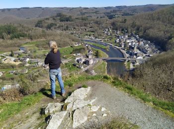
• Vresse-sur-Semois – Orchimont – Nafraiture – Membre – Laforêt – Vresse Oui, la province de Namur pousse une pointe l...

Senderismo
• Vresse-sur-Semois – Orchimont – Nafraiture – Vresse Oui, la province de Namur pousse une pointe loin vers le sud, ju...
Senderismo
• Vresse-sur-Semois – Orchimont – Nafraiture – Membre – Laforêt – Vresse Oui, la province de Namur pousse une pointe l...

Senderismo
Senderismo
Senderismo
Senderismo
Senderismo
Senderismo
Senderismo

Senderismo
Senderismo
Senderismo
Senderismo

A pie

A pie
A pie

A pie
20 excursiones mostradas en 390
Aplicación GPS de excursión GRATIS
 SityTrail
IGN / Institutos geográficos
SityTrail World
El mundo es suyo