![](/images/other/stat-length.png)
![Excursión Senderismo Saint-Étienne-de-Saint-Geoirs - RS-Mury - Photo](https://media.geolcdn.com/t/1900/400/ext.pjpeg?maxdim=2&url=https%3A%2F%2Fstatic1.geolcdn.com%2Fsiteimages%2Fupload%2Ffiles%2F1553511878bg_sport_marche.png)
RS-Mury
raymondfn
Usuario
![Longitud](/images/other/stat-length.png)
Longitud
5,4 km
![Altitud máxima](https://static1.geolcdn.com/siteimages/upload/files/1508320355ic_sort_altitude_max_24dp.png)
Altitud máxima
421 m
![Desnivel positivo](https://static1.geolcdn.com/siteimages/upload/files/1508320355ic_sort_den_pos_24dp.png)
Desnivel positivo
27 m
![Km-Effort](/images/other/stat-length.png)
Km-Effort
5,8 km
![Altitud mínima](https://static1.geolcdn.com/siteimages/upload/files/1508320355ic_sort_altitude_min_24dp.png)
Altitud mínima
398 m
![Desnivel negativo](https://static1.geolcdn.com/siteimages/upload/files/1508320355ic_sort_den_neg_24dp.png)
Desnivel negativo
28 m
![Boucle](https://static1.geolcdn.com/siteimages/upload/files/16400158638029165_repeat_loop_refresh_sync_direction_icon.png)
Boucle
Sí
Fecha de creación :
2019-06-05 12:05:38.5
Última modificación :
2020-01-13 16:42:29.483
![Senderismo](https://static1.geolcdn.com/sitytour/trail-icons/101.png)
1h17
Dificultad : Fácil
![Escanee este código QR para abrir la excursión en la aplicación SityTrail](https://capi.geolives.com/qq0zvz2zws4bq2lad0pu/sitytour/trails/2105343/qr.png?size=200)
Aplicación GPS de excursión GRATIS
A propósito
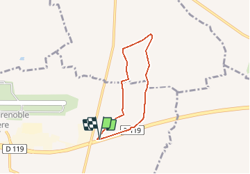
Ruta Senderismo de 5,4 km a descubrir en Auvergne-Rhône-Alpes, Isère, Saint-Étienne-de-Saint-Geoirs. Esta ruta ha sido propuesta por raymondfn.
Descripción
Les chemins qui contournent le bois de Mury n'existent pas (ils ne figurent pas au cadastre).
Le passage dans le bois (Mury) est absent sur 100 m, on peut passer en zigzagant...
Localización
País:
France
Región :
Auvergne-Rhône-Alpes
Departamento/provincia :
Isère
Municipio :
Saint-Étienne-de-Saint-Geoirs
Localidad:
Unknown
Salida:(Dec)
Salida:(UTM)
684657 ; 5025277 (31T) N.
Comentarios
Excursiones cerca
![Excursión Senderismo Bévenais - téléthon Bévenais - Photo](https://media.geolcdn.com/t/375/260/ext.jpg?maxdim=2&url=https%3A%2F%2Fstatic1.geolcdn.com%2Fsiteimages%2Fupload%2Ffiles%2F1553511878bg_sport_marche.png)
![Senderismo Senderismo](https://static1.geolcdn.com/sitytour/trail-icons/101.png)
téléthon Bévenais
Senderismo
Difícil
(1)
Bévenais,
Auvergne-Rhône-Alpes,
Isère,
France
![](/images/other/stat-length.png)
12 km | 17,6 km-effort
4h 9min
![](https://static1.geolcdn.com/siteimages/upload/files/16400158638029165_repeat_loop_refresh_sync_direction_icon.png)
Sí
![Excursión Senderismo Saint-Hilaire-de-la-Côte - RS-Côteau des épées - Photo](https://media.geolcdn.com/t/375/260/ext.jpg?maxdim=2&url=https%3A%2F%2Fstatic1.geolcdn.com%2Fsiteimages%2Fupload%2Ffiles%2F1553511878bg_sport_marche.png)
![Senderismo Senderismo](https://static1.geolcdn.com/sitytour/trail-icons/101.png)
RS-Côteau des épées
Senderismo
Fácil
(1)
Saint-Hilaire-de-la-Côte,
Auvergne-Rhône-Alpes,
Isère,
France
![](/images/other/stat-length.png)
4,5 km | 5,1 km-effort
1h 9min
![](https://static1.geolcdn.com/siteimages/upload/files/16400158638029165_repeat_loop_refresh_sync_direction_icon.png)
Sí
![Excursión Senderismo Saint-Hilaire-de-la-Côte - Bocsozel sentier medieval - Photo](https://media.geolcdn.com/t/375/260/ext.jpg?maxdim=2&url=https%3A%2F%2Fmedia.geolcdn.com%2Ff%2F91cbdc1b-8001-4f03-93a9-7d4d5430fde2.jpg)
![Senderismo Senderismo](https://static1.geolcdn.com/sitytour/trail-icons/101.png)
Bocsozel sentier medieval
Senderismo
Medio
Saint-Hilaire-de-la-Côte,
Auvergne-Rhône-Alpes,
Isère,
France
![](/images/other/stat-length.png)
13,1 km | 18,6 km-effort
6h 17min
![](https://static1.geolcdn.com/siteimages/upload/files/16400158638029165_repeat_loop_refresh_sync_direction_icon.png)
Sí
![Excursión Senderismo Bévenais - RD-Le-Grand-Lemps-Bevenais - Photo](https://media.geolcdn.com/t/375/260/ext.jpg?maxdim=2&url=https%3A%2F%2Fstatic1.geolcdn.com%2Fsiteimages%2Fupload%2Ffiles%2F1553511878bg_sport_marche.png)
![Senderismo Senderismo](https://static1.geolcdn.com/sitytour/trail-icons/101.png)
RD-Le-Grand-Lemps-Bevenais
Senderismo
Medio
(1)
Bévenais,
Auvergne-Rhône-Alpes,
Isère,
France
![](/images/other/stat-length.png)
8,6 km | 10,4 km-effort
2h 22min
![](https://static1.geolcdn.com/siteimages/upload/files/16400158638029165_repeat_loop_refresh_sync_direction_icon.png)
Sí
![Excursión Senderismo Saint-Hilaire-de-la-Côte - RS-St-Hillaire-de-la-Côte-Fournache - Photo](https://media.geolcdn.com/t/375/260/ext.jpg?maxdim=2&url=https%3A%2F%2Fstatic1.geolcdn.com%2Fsiteimages%2Fupload%2Ffiles%2F1553511878bg_sport_marche.png)
![Senderismo Senderismo](https://static1.geolcdn.com/sitytour/trail-icons/101.png)
RS-St-Hillaire-de-la-Côte-Fournache
Senderismo
Medio
(1)
Saint-Hilaire-de-la-Côte,
Auvergne-Rhône-Alpes,
Isère,
France
![](/images/other/stat-length.png)
5,2 km | 6,1 km-effort
1h 23min
![](https://static1.geolcdn.com/siteimages/upload/files/16400158638029165_repeat_loop_refresh_sync_direction_icon.png)
Sí
![Excursión Senderismo La Frette - Le Marais et le Château de La Frette - Photo](https://media.geolcdn.com/t/375/260/ext.jpg?maxdim=2&url=https%3A%2F%2Fstatic1.geolcdn.com%2Fsiteimages%2Fupload%2Ffiles%2F1553511878bg_sport_marche.png)
![Senderismo Senderismo](https://static1.geolcdn.com/sitytour/trail-icons/101.png)
Le Marais et le Château de La Frette
Senderismo
Medio
(1)
La Frette,
Auvergne-Rhône-Alpes,
Isère,
France
![](/images/other/stat-length.png)
8,1 km | 9,6 km-effort
2h 5min
![](https://static1.geolcdn.com/siteimages/upload/files/16400158638029165_repeat_loop_refresh_sync_direction_icon.png)
Sí
![Excursión Senderismo Saint-Étienne-de-Saint-Geoirs - st Étienne St geoir - Photo](https://media.geolcdn.com/t/375/260/ext.jpg?maxdim=2&url=https%3A%2F%2Fmedia.geolcdn.com%2Ff%2Ff7409348-5c5a-4c35-a033-1b79343cad9a.jpg)
![Senderismo Senderismo](https://static1.geolcdn.com/sitytour/trail-icons/101.png)
st Étienne St geoir
Senderismo
Fácil
Saint-Étienne-de-Saint-Geoirs,
Auvergne-Rhône-Alpes,
Isère,
France
![](/images/other/stat-length.png)
13,2 km | 16,7 km-effort
3h 48min
![](https://static1.geolcdn.com/siteimages/upload/files/16400158638029165_repeat_loop_refresh_sync_direction_icon.png)
Sí
![Excursión Senderismo Saint-Hilaire-de-la-Côte - RR-SHDLC-Le Not - Photo](https://media.geolcdn.com/t/375/260/ext.jpg?maxdim=2&url=https%3A%2F%2Fstatic1.geolcdn.com%2Fsiteimages%2Fupload%2Ffiles%2F1553511878bg_sport_marche.png)
![Senderismo Senderismo](https://static1.geolcdn.com/sitytour/trail-icons/101.png)
RR-SHDLC-Le Not
Senderismo
Fácil
Saint-Hilaire-de-la-Côte,
Auvergne-Rhône-Alpes,
Isère,
France
![](/images/other/stat-length.png)
4,8 km | 5,5 km-effort
1h 15min
![](https://static1.geolcdn.com/siteimages/upload/files/16400158638029165_repeat_loop_refresh_sync_direction_icon.png)
Sí
![Excursión Senderismo Sillans - SityTrail - RD-Sillans-de Recandoux à la Ravageuse - Photo](https://media.geolcdn.com/t/375/260/ext.jpg?maxdim=2&url=https%3A%2F%2Fstatic1.geolcdn.com%2Fsiteimages%2Fupload%2Ffiles%2F1553511878bg_sport_marche.png)
![Senderismo Senderismo](https://static1.geolcdn.com/sitytour/trail-icons/101.png)
SityTrail - RD-Sillans-de Recandoux à la Ravageuse
Senderismo
Medio
(1)
Sillans,
Auvergne-Rhône-Alpes,
Isère,
France
![](/images/other/stat-length.png)
8,1 km | 8,7 km-effort
1h 59min
![](https://static1.geolcdn.com/siteimages/upload/files/16400158638029165_repeat_loop_refresh_sync_direction_icon.png)
Sí