![](/images/other/stat-length.png)
![Excursión A pie Saint-Pierre-de-Manneville - Du coté du Manoir de Villers - Photo](https://media.geolcdn.com/t/1900/400/ext.pjpeg?maxdim=2&url=https%3A%2F%2Fstatic1.geolcdn.com%2Fsiteimages%2Fupload%2Ffiles%2F1545311037marcheuse_200dpi.jpg)
Du coté du Manoir de Villers
JMCMoreau
Usuario
![Longitud](/images/other/stat-length.png)
Longitud
11 km
![Altitud máxima](https://static1.geolcdn.com/siteimages/upload/files/1508320355ic_sort_altitude_max_24dp.png)
Altitud máxima
79 m
![Desnivel positivo](https://static1.geolcdn.com/siteimages/upload/files/1508320355ic_sort_den_pos_24dp.png)
Desnivel positivo
109 m
![Km-Effort](/images/other/stat-length.png)
Km-Effort
12,5 km
![Altitud mínima](https://static1.geolcdn.com/siteimages/upload/files/1508320355ic_sort_altitude_min_24dp.png)
Altitud mínima
0 m
![Desnivel negativo](https://static1.geolcdn.com/siteimages/upload/files/1508320355ic_sort_den_neg_24dp.png)
Desnivel negativo
108 m
![Boucle](https://static1.geolcdn.com/siteimages/upload/files/16400158638029165_repeat_loop_refresh_sync_direction_icon.png)
Boucle
Sí
Fecha de creación :
2020-06-01 16:08:03.983
Última modificación :
2020-06-01 16:26:49.719
![A pie](https://static1.geolcdn.com/sitytour/trail-icons/100.png)
2h45
Dificultad : Fácil
![Escanee este código QR para abrir la excursión en la aplicación SityTrail](https://capi.geolives.com/qq0zvz2zws4bq2lad0pu/sitytour/trails/2421328/qr.png?size=200)
Aplicación GPS de excursión GRATIS
A propósito
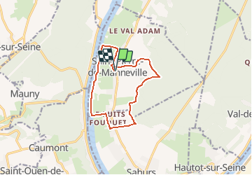
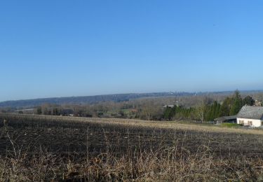
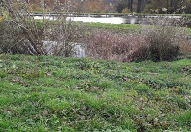
Ruta A pie de 11 km a descubrir en Normandía, Sena-Marítimo, Saint-Pierre-de-Manneville. Esta ruta ha sido propuesta por JMCMoreau.
Descripción
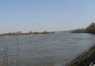
Randonnée facile qui permet de découvrir le calme des boucles de la Seine. Pour une 1/2 journée de balade seul, en famille ou entre amis.
Localización
País:
France
Región :
Normandía
Departamento/provincia :
Sena-Marítimo
Municipio :
Saint-Pierre-de-Manneville
Localidad:
Unknown
Salida:(Dec)
Salida:(UTM)
349876 ; 5472973 (31U) N.
Comentarios
Excursiones cerca
![Excursión Senderismo Hautot-sur-Seine - Hautot-sur-seine 11km - Photo](https://media.geolcdn.com/t/375/260/ext.jpg?maxdim=2&url=https%3A%2F%2Fmedia.geolcdn.com%2Ff%2F2e225eeb-e814-4a2c-a540-ca57c244afd9.jpg)
![Senderismo Senderismo](https://static1.geolcdn.com/sitytour/trail-icons/101.png)
Hautot-sur-seine 11km
Senderismo
Medio
(2)
Hautot-sur-Seine,
Normandía,
Sena-Marítimo,
France
![](/images/other/stat-length.png)
11 km | 12,2 km-effort
2h 37min
![](https://static1.geolcdn.com/siteimages/upload/files/16400158638029165_repeat_loop_refresh_sync_direction_icon.png)
Sí
![Excursión Senderismo Saint-Ouen-de-Thouberville - Saint-Ouen de Thouberville- Le Mesnil et la Pierre TTournante - Photo](https://media.geolcdn.com/t/375/260/ext.jpg?maxdim=2&url=https%3A%2F%2Fmedia.geolcdn.com%2Ff%2Ff2450d67-38f3-46a5-aba6-c5e54414bed0.jpg)
![Senderismo Senderismo](https://static1.geolcdn.com/sitytour/trail-icons/101.png)
Saint-Ouen de Thouberville- Le Mesnil et la Pierre TTournante
Senderismo
Medio
(1)
Saint-Ouen-de-Thouberville,
Normandía,
Eure,
France
![](/images/other/stat-length.png)
12,5 km | 15,3 km-effort
3h 35min
![](https://static1.geolcdn.com/siteimages/upload/files/16400158638029165_repeat_loop_refresh_sync_direction_icon.png)
Sí
![Excursión Senderismo Canteleu - canteleu parc animalier - Photo](https://media.geolcdn.com/t/375/260/ext.jpg?maxdim=2&url=https%3A%2F%2Fstatic1.geolcdn.com%2Fsiteimages%2Fupload%2Ffiles%2F1553511878bg_sport_marche.png)
![Senderismo Senderismo](https://static1.geolcdn.com/sitytour/trail-icons/101.png)
canteleu parc animalier
Senderismo
Muy fácil
(1)
Canteleu,
Normandía,
Sena-Marítimo,
France
![](/images/other/stat-length.png)
6,5 km | 7,4 km-effort
1h 37min
![](https://static1.geolcdn.com/siteimages/upload/files/16400158638029165_repeat_loop_refresh_sync_direction_icon.png)
Sí
![Excursión Senderismo Saint-Pierre-de-Manneville - st pierre de mainneville - Photo](https://media.geolcdn.com/t/375/260/ext.jpg?maxdim=2&url=https%3A%2F%2Fmedia.geolcdn.com%2Ff%2Fd707c7b4-7da5-46fa-aedb-46579dbd0e82.jpg)
![Senderismo Senderismo](https://static1.geolcdn.com/sitytour/trail-icons/101.png)
st pierre de mainneville
Senderismo
Medio
Saint-Pierre-de-Manneville,
Normandía,
Sena-Marítimo,
France
![](/images/other/stat-length.png)
7,6 km | 8,9 km-effort
1h 25min
![](https://static1.geolcdn.com/siteimages/upload/files/16400158638029165_repeat_loop_refresh_sync_direction_icon.png)
Sí
![Excursión Senderismo La Bouille - La Bouille- Cote Albert Lambert-Robert le Diable - Photo](https://media.geolcdn.com/t/375/260/ext.jpg?maxdim=2&url=https%3A%2F%2Fmedia.geolcdn.com%2Ff%2F6619d219-dc7a-4ef0-85ef-d79a78fa0fb8.jpg)
![Senderismo Senderismo](https://static1.geolcdn.com/sitytour/trail-icons/101.png)
La Bouille- Cote Albert Lambert-Robert le Diable
Senderismo
Difícil
La Bouille,
Normandía,
Sena-Marítimo,
France
![](/images/other/stat-length.png)
14,9 km | 18,8 km-effort
4h 23min
![](https://static1.geolcdn.com/siteimages/upload/files/16400158638029165_repeat_loop_refresh_sync_direction_icon.png)
Sí
![Excursión Senderismo Sahurs - 20231216-sahurs - Photo](https://media.geolcdn.com/t/375/260/ext.jpg?maxdim=2&url=https%3A%2F%2Fmedia.geolcdn.com%2Ff%2F6157c822-41a3-4d46-8844-2a9e1019e224.jpg)
![Senderismo Senderismo](https://static1.geolcdn.com/sitytour/trail-icons/101.png)
20231216-sahurs
Senderismo
Medio
Sahurs,
Normandía,
Sena-Marítimo,
France
![](/images/other/stat-length.png)
12,8 km | 14,2 km-effort
3h 18min
![](https://static1.geolcdn.com/siteimages/upload/files/16400158638029165_repeat_loop_refresh_sync_direction_icon.png)
Sí
![Excursión Senderismo La Bouille - 20220322-La Bouille - Photo](https://media.geolcdn.com/t/375/260/ext.jpg?maxdim=2&url=https%3A%2F%2Fmedia.geolcdn.com%2Ff%2F96ba0547-8e50-484d-bad9-6341bb12ca51.JPG)
![Senderismo Senderismo](https://static1.geolcdn.com/sitytour/trail-icons/101.png)
20220322-La Bouille
Senderismo
Medio
La Bouille,
Normandía,
Sena-Marítimo,
France
![](/images/other/stat-length.png)
12,8 km | 15,8 km-effort
3h 36min
![](https://static1.geolcdn.com/siteimages/upload/files/16400158638029165_repeat_loop_refresh_sync_direction_icon.png)
Sí
![Excursión Senderismo Quevillon - 20211218-Quevillon - Photo](https://media.geolcdn.com/t/375/260/ext.jpg?maxdim=2&url=https%3A%2F%2Fmedia.geolcdn.com%2Ff%2F9071ef4c-ac24-454c-a243-e178914fea37.JPG)
![Senderismo Senderismo](https://static1.geolcdn.com/sitytour/trail-icons/101.png)
20211218-Quevillon
Senderismo
Medio
Quevillon,
Normandía,
Sena-Marítimo,
France
![](/images/other/stat-length.png)
12,7 km | 15,3 km-effort
3h 34min
![](https://static1.geolcdn.com/siteimages/upload/files/16400158638029165_repeat_loop_refresh_sync_direction_icon.png)
Sí
![Excursión Senderismo Saint-Ouen-de-Thouberville - Saint-Ouen de Thouberville. Vers la pierre Tourmante et le Mesnil version 12-11-21 - Photo](https://media.geolcdn.com/t/375/260/ext.jpg?maxdim=2&url=https%3A%2F%2Fmedia.geolcdn.com%2Ff%2Fb86f4944-9744-4f8e-8b37-981417450b71.jpg)
![Senderismo Senderismo](https://static1.geolcdn.com/sitytour/trail-icons/101.png)
Saint-Ouen de Thouberville. Vers la pierre Tourmante et le Mesnil version 12...
Senderismo
Difícil
Saint-Ouen-de-Thouberville,
Normandía,
Eure,
France
![](/images/other/stat-length.png)
12,8 km | 15,6 km-effort
3h 55min
![](https://static1.geolcdn.com/siteimages/upload/files/16400158638029165_repeat_loop_refresh_sync_direction_icon.png)
Sí
parfait