Excursión Senderismo Nogent-le-Rotrou - SityTrail - Nogent-le-Rotrou - Saint-Victor-de-Buthon 19 km - Photo

SityTrail - Nogent-le-Rotrou - Saint-Victor-de-Buthon 19 km

Un maillage d'une centaine de parcours pour composer à la carte sa randonnée itinérante percheronne.

© OpenStreetMap contributors
Longitud
Longitud
19 km
Altitud máxima
Altitud máxima
236 m
Desnivel positivo
Desnivel positivo
338 m
Km-Effort
Km-Effort  
23 km
Altitud mínima
Altitud mínima
112 m
Desnivel negativo
Desnivel negativo
240 m
Boucle
Boucle
No
Fecha de creación :
2020-08-21 18:56:54.334
Última modificación :
2021-08-02 19:17:19.624

(0 Opinión)

Senderismo
Senderismo
5h05
Dificultad : Muy difícil

Escanee este código QR para abrir la excursión en la aplicación SityTrail

Aplicación GPS de excursión GRATIS

Logo SityTrail SityTrail

IGN / Institutos geográficos

Descargar SityTrail en App Store Descargar SityTrail en Google Play

Logo SityTrail SityTrail World

El mundo es suyo

Descargar SityTrail en App Store Descargar SityTrail en Google Play Descargar SityTrail en Huawei AppGallery

A propósito

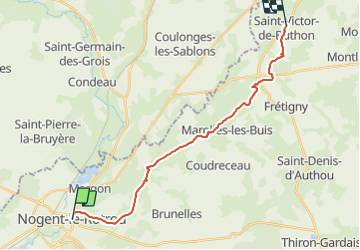
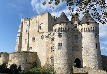
Ruta Senderismo de 19 km a descubrir en Centro, Eure-y-Loir, Nogent-le-Rotrou. Esta ruta ha sido propuesta por Traversées Percheronnes.

Descripción

LES TRAVERSÉES PERCHERONNES..

Vous offrent la description de près de 1700 kilomètres de chemins de randonnée percherons organisés en une centaine d'étapes, chacune réalisable dans la journée, reliant nos plus belles villes et nos plus beaux villages percherons, en un maillage serré pour que vous puissiez composer à la carte votre randonnée itinérante à étapes multiples, sur le nombre de jours de votre choix au coeur même du Parc Naturel Régional du Perche.

Les chemins que nous vous proposons n'ont pas de balisage spécifique, mais empruntent souvent un segment des nombreux chemins balisés sillonnant le Perche : chemins locaux(les PR  balisés en jaune), régionaux (les GRP balisés en rouge et jaune), les chemins de Grande Randonnée (les GR 22 et 35 balisés en rouge et blanc), le Tour des collines du Perche (identifié en orange), le chemin du Mont Saint-Michel (balisé en bleu), la Véloscénie, qui sont tous entretenus et généralement en bon état.

Alors, pour suivre votre trace : Téléchargez la carte au format pdf et importez le fichier GPX dans votre système de GPS de rando… notamment l’application SityTrail sur les smartphones ou iPhones
Et maintenant, à vous de jouer. Bonne balade à tous.... Et n'oubliez pas, à votre retour, de nous faire part de votre ressenti.

De NOGENT-LE-ROTROU à SAINT-VICTOR-DE-BUTHON
Rédaction en cours

De SAINT-VICTOR-DE-BUTHON à NOGENT-LE-ROTROU
Rédaction en cours

Perfil altimétrico

Fotos

Localización

País:
France
Región :
Centro
Departamento/provincia :
Eure-y-Loir
Municipio :
Nogent-le-Rotrou
Localidad:
Unknown
Salida:(UTM)
338537 ; 5354343 (31U) N.

Excursiones cerca

Excursión Senderismo Trizay-Coutretot-Saint-Serge - Trizay 100-B - Photo
Senderismo
togolo28

Senderismo

Difícil
(2)
Trizay-Coutretot-Saint-Serge, Centro, Eure-y-Loir, France
48 km | 56 km-effort
12h 1min
Excursión Senderismo Nogent-le-Rotrou - NOGENT LE ROTROU - Photo
Senderismo
jeannine grandjean

Senderismo

Medio
Nogent-le-Rotrou, Centro, Eure-y-Loir, France
5,8 km | 6,9 km-effort
1h 33min
Excursión Senderismo Arcisses - 2023-04-24_20h15m45_Ozée  9,1 km - Photo
Senderismo
ODDAD78

Senderismo

Medio
(1)
Arcisses, Centro, Eure-y-Loir, France
9,1 km | 11,2 km-effort
2h 32min
Excursión Senderismo Nogent-le-Rotrou - 10981160-ZProjet Nogent - Thiron 2 - Photo
Senderismo

Senderismo

Muy difícil
Nogent-le-Rotrou, Centro, Eure-y-Loir, France
22 km | 26 km-effort
6h 0min
No
Excursión Senderismo Nogent-le-Rotrou - Nogent-le-Rotrou - Saint-Pierre-la-Bruyère 5,5 km - Photo
Senderismo

Senderismo

Fácil
Nogent-le-Rotrou, Centro, Eure-y-Loir, France
5,5 km | 6,9 km-effort
3h 42min
No
Excursión Senderismo Saint-Pierre-la-Bruyère - Condé-sur-Huisne - Saint-Pierre-la-Bruyère  via Villeray 8,5 km - Photo
Senderismo

Senderismo

Fácil
Saint-Pierre-la-Bruyère, Normandía, Orne, France
8,5 km | 10 km-effort
3h 23min
No
Excursión Senderismo Nogent-le-Rotrou - Nogent-le-Rotrou - Rémalard 18 km - Photo
Senderismo

Senderismo

Fácil
Nogent-le-Rotrou, Centro, Eure-y-Loir, France
18 km | 21 km-effort
4h 24min
No
Excursión Senderismo Arcisses - Autour de Margon - Photo
Senderismo
tracegps

Senderismo

Medio
Arcisses, Centro, Eure-y-Loir, France
18,2 km | 21 km-effort
3h 25min
Excursión Senderismo Perche en Nocé - Nobles Logis (Dancé) 16 km - Photo
Senderismo
ODDAD78

Senderismo

Medio
Perche en Nocé, Normandía, Orne, France
16,5 km | 19,4 km-effort
4h 14min


Cerrar
Mis suscripciones