![](/images/other/stat-length.png)
![Excursión Senderismo Seur - seur fougères sur bievre - Photo](https://media.geolcdn.com/t/1900/400/ext.pjpeg?maxdim=2&url=https%3A%2F%2Fmedia.geolcdn.com%2Ff%2F5d771a75-33af-4508-ab11-7629c86467f5.jpg)
seur fougères sur bievre
kasyope
Usuario
![Longitud](/images/other/stat-length.png)
Longitud
21 km
![Altitud máxima](https://static1.geolcdn.com/siteimages/upload/files/1508320355ic_sort_altitude_max_24dp.png)
Altitud máxima
111 m
![Desnivel positivo](https://static1.geolcdn.com/siteimages/upload/files/1508320355ic_sort_den_pos_24dp.png)
Desnivel positivo
150 m
![Km-Effort](/images/other/stat-length.png)
Km-Effort
23 km
![Altitud mínima](https://static1.geolcdn.com/siteimages/upload/files/1508320355ic_sort_altitude_min_24dp.png)
Altitud mínima
69 m
![Desnivel negativo](https://static1.geolcdn.com/siteimages/upload/files/1508320355ic_sort_den_neg_24dp.png)
Desnivel negativo
149 m
![Boucle](https://static1.geolcdn.com/siteimages/upload/files/16400158638029165_repeat_loop_refresh_sync_direction_icon.png)
Boucle
Sí
Fecha de creación :
2021-04-18 09:43:56.885
Última modificación :
2021-04-18 14:17:21.07
![Senderismo](https://static1.geolcdn.com/sitytour/trail-icons/101.png)
4h00
Dificultad : Medio
![Escanee este código QR para abrir la excursión en la aplicación SityTrail](https://capi.geolives.com/qq0zvz2zws4bq2lad0pu/sitytour/trails/2752465/qr.png?size=200)
Aplicación GPS de excursión GRATIS
A propósito
Ruta Senderismo de 21 km a descubrir en Centro, Loir y Cher, Seur. Esta ruta ha sido propuesta por kasyope.
Descripción
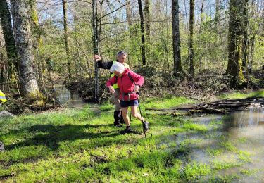
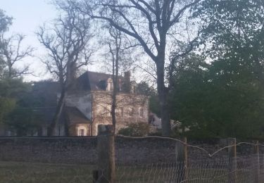
attention difficulté pour trouver le passage à la petite ardoise. On a l'impression de rentrer dans une propriété. voir les photos du passage
Localización
País:
France
Región :
Centro
Departamento/provincia :
Loir y Cher
Municipio :
Seur
Localidad:
Unknown
Salida:(Dec)
Salida:(UTM)
374554 ; 5262624 (31T) N.
Comentarios
Excursiones cerca
![Excursión Bici de carretera Cellettes - Entre vignoble et châteaux - Photo](https://media.geolcdn.com/t/375/260/ext.jpg?maxdim=2&url=https%3A%2F%2Fmedia.geolcdn.com%2Ff%2Ffd76316a-e28d-4952-828d-db3e12d1d6c9.jpg)
![Bici de carretera Bici de carretera](https://static1.geolcdn.com/sitytour/trail-icons/201.png)
Entre vignoble et châteaux
Bici de carretera
Medio
(1)
Cellettes,
Centro,
Loir y Cher,
France
![](/images/other/stat-length.png)
25 km | 28 km-effort
1h 42min
![](https://static1.geolcdn.com/siteimages/upload/files/16400158638029165_repeat_loop_refresh_sync_direction_icon.png)
Sí
![Excursión A pie Seur - seur, cande sur beuvron, madon, chailles,la haye,la boissiere,seur - Photo](https://media.geolcdn.com/t/375/260/ext.jpg?maxdim=2&url=https%3A%2F%2Fstatic1.geolcdn.com%2Fsiteimages%2Fupload%2Ffiles%2F1545311037marcheuse_200dpi.jpg)
![A pie A pie](https://static1.geolcdn.com/sitytour/trail-icons/100.png)
seur, cande sur beuvron, madon, chailles,la haye,la boissiere,seur
A pie
Medio
(1)
Seur,
Centro,
Loir y Cher,
France
![](/images/other/stat-length.png)
26 km | 29 km-effort
6h 34min
![](https://static1.geolcdn.com/siteimages/upload/files/16400158638029165_repeat_loop_refresh_sync_direction_icon.png)
Sí
![Excursión Senderismo Le Controis-en-Sologne - ouchamps - Photo](https://media.geolcdn.com/t/375/260/ext.jpg?maxdim=2&url=https%3A%2F%2Fmedia.geolcdn.com%2Ff%2Fbc590b0c-8269-4096-bb2b-79af6aa06278.jpg)
![Senderismo Senderismo](https://static1.geolcdn.com/sitytour/trail-icons/101.png)
ouchamps
Senderismo
Medio
Le Controis-en-Sologne,
Centro,
Loir y Cher,
France
![](/images/other/stat-length.png)
14,7 km | 16,3 km-effort
1h 14min
![](https://static1.geolcdn.com/siteimages/upload/files/16400158638029165_repeat_loop_refresh_sync_direction_icon.png)
Sí
![Excursión Senderismo Seur - seur.cande sur beuvron.chailles.seur - Photo](https://media.geolcdn.com/t/375/260/ext.jpg?maxdim=2&url=https%3A%2F%2Fmedia.geolcdn.com%2Ff%2F63e5c44b-68e2-438b-ba05-41f8acdb9a0f.jpg)
![Senderismo Senderismo](https://static1.geolcdn.com/sitytour/trail-icons/101.png)
seur.cande sur beuvron.chailles.seur
Senderismo
Difícil
Seur,
Centro,
Loir y Cher,
France
![](/images/other/stat-length.png)
27 km | 30 km-effort
5h 16min
![](https://static1.geolcdn.com/siteimages/upload/files/16400158638029165_repeat_loop_refresh_sync_direction_icon.png)
Sí
![Excursión Senderismo Cellettes - Cellettes 2024-05-30 - Photo](https://media.geolcdn.com/t/375/260/ext.jpg?maxdim=2&url=https%3A%2F%2Fmedia.geolcdn.com%2Ff%2Fe0d655ed-df76-4cb5-852f-2dfda39e603d.jpg)
![Senderismo Senderismo](https://static1.geolcdn.com/sitytour/trail-icons/101.png)
Cellettes 2024-05-30
Senderismo
Fácil
Cellettes,
Centro,
Loir y Cher,
France
![](/images/other/stat-length.png)
14 km | 15,7 km-effort
2h 51min
![](https://static1.geolcdn.com/siteimages/upload/files/16400158638029165_repeat_loop_refresh_sync_direction_icon.png)
Sí
![Excursión Senderismo Cellettes - cellettes - Photo](https://media.geolcdn.com/t/375/260/ext.jpg?maxdim=2&url=https%3A%2F%2Fstatic1.geolcdn.com%2Fsiteimages%2Fupload%2Ffiles%2F1553511878bg_sport_marche.png)
![Senderismo Senderismo](https://static1.geolcdn.com/sitytour/trail-icons/101.png)
cellettes
Senderismo
Difícil
(1)
Cellettes,
Centro,
Loir y Cher,
France
![](/images/other/stat-length.png)
14,6 km | 16,5 km-effort
3h 20min
![](https://static1.geolcdn.com/siteimages/upload/files/16400158638029165_repeat_loop_refresh_sync_direction_icon.png)
Sí
![Excursión Senderismo Monthou-sur-Bièvre - BBR 2023-09-06 Monthou sur Bièvre - Photo](https://media.geolcdn.com/t/375/260/ext.jpg?maxdim=2&url=https%3A%2F%2Fstatic1.geolcdn.com%2Fsiteimages%2Fupload%2Ffiles%2F1553511878bg_sport_marche.png)
![Senderismo Senderismo](https://static1.geolcdn.com/sitytour/trail-icons/101.png)
BBR 2023-09-06 Monthou sur Bièvre
Senderismo
Medio
Monthou-sur-Bièvre,
Centro,
Loir y Cher,
France
![](/images/other/stat-length.png)
14,8 km | 16,7 km-effort
3h 47min
![](https://static1.geolcdn.com/siteimages/upload/files/16400158638029165_repeat_loop_refresh_sync_direction_icon.png)
Sí
![Excursión Senderismo Cellettes - GR Loire de Cellettes au château de Chaumont - Photo](https://media.geolcdn.com/t/375/260/ext.jpg?maxdim=2&url=https%3A%2F%2Fstatic1.geolcdn.com%2Fsiteimages%2Fupload%2Ffiles%2F1553511878bg_sport_marche.png)
![Senderismo Senderismo](https://static1.geolcdn.com/sitytour/trail-icons/101.png)
GR Loire de Cellettes au château de Chaumont
Senderismo
Muy difícil
Cellettes,
Centro,
Loir y Cher,
France
![](/images/other/stat-length.png)
24 km | 28 km-effort
9h 59min
![](https://static1.geolcdn.com/siteimages/upload/files/16400158638029165_repeat_loop_refresh_sync_direction_icon.png)
No
![Excursión Senderismo Chailles - chailles 1 - Photo](https://media.geolcdn.com/t/375/260/ext.jpg?maxdim=2&url=https%3A%2F%2Fstatic1.geolcdn.com%2Fsiteimages%2Fupload%2Ffiles%2F1553511878bg_sport_marche.png)
![Senderismo Senderismo](https://static1.geolcdn.com/sitytour/trail-icons/101.png)
chailles 1
Senderismo
Medio
Chailles,
Centro,
Loir y Cher,
France
![](/images/other/stat-length.png)
9,2 km | 10,8 km-effort
2h 27min
![](https://static1.geolcdn.com/siteimages/upload/files/16400158638029165_repeat_loop_refresh_sync_direction_icon.png)
Sí