Excursión A pie Hastière - Les Grottes du Pont d'Arcole - Photo

Les Grottes du Pont d'Arcole

Randonnées du CGT GUIDE+

© OpenStreetMap contributors
Longitud
Longitud
4,8 km
Altitud máxima
Altitud máxima
235 m
Desnivel positivo
Desnivel positivo
132 m
Km-Effort
Km-Effort  
6,6 km
Altitud mínima
Altitud mínima
96 m
Desnivel negativo
Desnivel negativo
137 m
Boucle
Boucle
Fecha de creación :
2022-02-08 11:32:40.093
Última modificación :
2022-02-21 10:13:58.525

(1 Opinión)

A pie
A pie
1h29
Dificultad : Fácil

Escanee este código QR para abrir la excursión en la aplicación SityTrail

Aplicación GPS de excursión GRATIS

Logo SityTrail SityTrail

IGN / Institutos geográficos

Descargar SityTrail en App Store Descargar SityTrail en Google Play

Logo SityTrail SityTrail World

El mundo es suyo

Descargar SityTrail en App Store Descargar SityTrail en Google Play Descargar SityTrail en Huawei AppGallery

A propósito

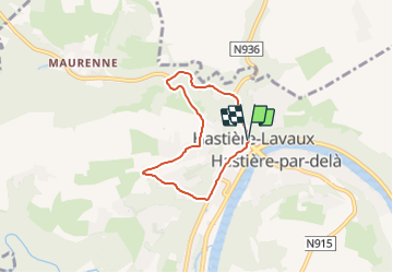
Ruta A pie de 4,8 km a descubrir en Valonia, Namur, Hastière. Esta ruta ha sido propuesta por Commissariat général au Tourisme.

Descripción

Trail created by Vallée de la Meuse Namur-Dinant.


This 4.5 km walk will let you to have a look at the site of the old mill of Hastière, the dolomite rocks of Tahaut, the rock of the Sacred Heart as well as the cave of Notre-Dame de Lourdes. You will take the bridge over the Feron river and reach the caves of the Pont d'Arcole. You will admire the Feron gorges and continue to the hamlet of Inzemont. Further on, the path on the left descends towards the Crupet valley and reaches the Thylère castle before reaching the village.


Perfil altimétrico

Fotos

Localización

País:
Belgium
Región :
Valonia
Departamento/provincia :
Namur
Municipio :
Hastière
Localidad:
Unknown
Salida:(Dec)
Salida:(UTM)
630203 ; 5564359 (31U) N.

Comentarios

Por favor conéctese para dejar un comentario o una evaluación


Excursiones cerca

Excursión Senderismo Hastière - Balade de Hastière à Waulsort - Photo
Senderismo
GUIDE
Desrumaux

Senderismo

Medio
(2)
Hastière, Valonia, Namur, Belgium
10,8 km | 13,8 km-effort
3h 2min
Excursión Senderismo Hastière - RB-Na-10 Raccourci 2 - Sur les crêtes mosanes - Photo
Senderismo
PRO

Senderismo

Fácil
(2)
Hastière, Valonia, Namur, Belgium
18,1 km | 25 km-effort
4h 29min
Excursión Senderismo Hastière - RB-Na-10 Raccourci 1 - Sur les crêtes mosanes - Photo
Senderismo
PRO

Senderismo

Medio
(3)
Hastière, Valonia, Namur, Belgium
15,3 km | 21 km-effort
5h 28min
Excursión Senderismo Hastière - RB-Na-10 - Sur les crêtes mosanes - Photo
Senderismo
PRO

Senderismo

Medio
(4)
Hastière, Valonia, Namur, Belgium
22 km | 29 km-effort
6h 21min
Excursión Senderismo Hastière - Hastiere - Photo
Senderismo
DoBelle

Senderismo

Difícil
(1)
Hastière, Valonia, Namur, Belgium
32 km | 41 km-effort
6h 22min
Excursión Senderismo Hastière - Balade de Hastière à Hermeton - Photo
Senderismo
GUIDE
Desrumaux

Senderismo

Fácil
(1)
Hastière, Valonia, Namur, Belgium
13,1 km | 16,8 km-effort
3h 37min
Excursión Senderismo Hastière - Waulsort - Circuit Natura 2000, des sites qui valent le détour - Na08 - Photo
Senderismo
GUIDE+

Senderismo

Muy fácil
(4)
Hastière, Valonia, Namur, Belgium
4,5 km | 6,9 km-effort
1h 40min
Excursión Senderismo Doische - De Gochenee vers Soulme par la vallee de l'Ermeton - Photo
Senderismo
GUIDE
Desrumaux

Senderismo

Medio
(1)
Doische, Valonia, Namur, Belgium
18,5 km | 24 km-effort
4h 40min
Excursión Senderismo Onhaye - Balade entre Flavion et Molignée - Photo
Senderismo
GUIDE
Desrumaux

Senderismo

Fácil
(5)
Onhaye, Valonia, Namur, Belgium
13,3 km | 16,9 km-effort
3h 20min


Cerrar
Mis suscripciones