![](/images/other/stat-length.png)
![Excursión Senderismo Condillac - 2022-09-27_13h27m21_14402803 - Photo](https://media.geolcdn.com/t/1900/400/ext.pjpeg?maxdim=2&url=https%3A%2F%2Fmedia.geolcdn.com%2Ff%2F417c49db-a62e-48c6-abe7-64344247f290.jpg)
2022-09-27_13h27m21_14402803
chancha
Usuario
![Longitud](/images/other/stat-length.png)
Longitud
7,2 km
![Altitud máxima](https://static1.geolcdn.com/siteimages/upload/files/1508320355ic_sort_altitude_max_24dp.png)
Altitud máxima
417 m
![Desnivel positivo](https://static1.geolcdn.com/siteimages/upload/files/1508320355ic_sort_den_pos_24dp.png)
Desnivel positivo
335 m
![Km-Effort](/images/other/stat-length.png)
Km-Effort
11,7 km
![Altitud mínima](https://static1.geolcdn.com/siteimages/upload/files/1508320355ic_sort_altitude_min_24dp.png)
Altitud mínima
169 m
![Desnivel negativo](https://static1.geolcdn.com/siteimages/upload/files/1508320355ic_sort_den_neg_24dp.png)
Desnivel negativo
333 m
![Boucle](https://static1.geolcdn.com/siteimages/upload/files/16400158638029165_repeat_loop_refresh_sync_direction_icon.png)
Boucle
Sí
Fecha de creación :
2022-09-27 11:27:21.771
Última modificación :
2022-09-28 07:29:22.011
![Senderismo](https://static1.geolcdn.com/sitytour/trail-icons/101.png)
2h38
Dificultad : Medio
![Escanee este código QR para abrir la excursión en la aplicación SityTrail](https://capi.geolives.com/qq0zvz2zws4bq2lad0pu/sitytour/trails/3405384/qr.png?size=200)
Aplicación GPS de excursión GRATIS
A propósito
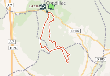
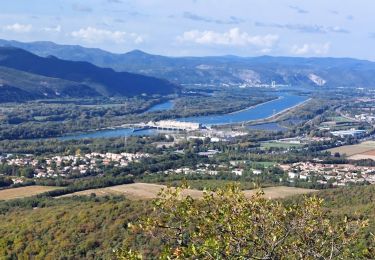
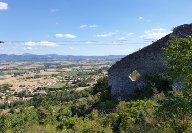
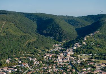
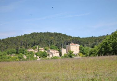
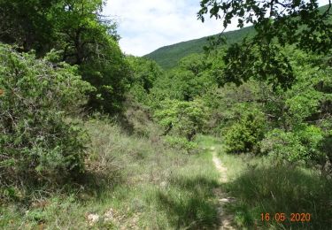
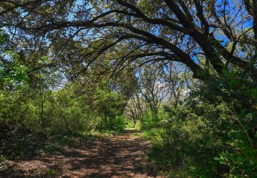
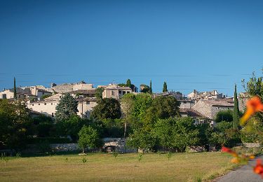
Ruta Senderismo de 7,2 km a descubrir en Auvergne-Rhône-Alpes, Drôme, Condillac. Esta ruta ha sido propuesta por chancha.
Descripción
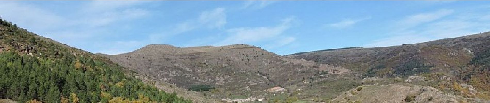
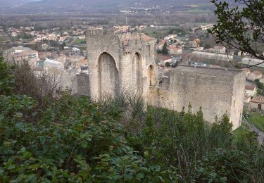
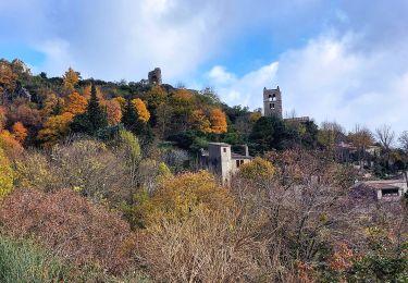
Un point de vue exceptionnel sur le château de Condillac au départ, et très vite la pente s'affirme! La vue récompensera vos efforts quand vous aurez gravi le rocher de Ruas…
Localización
País:
France
Región :
Auvergne-Rhône-Alpes
Departamento/provincia :
Drôme
Municipio :
Condillac
Localidad:
Unknown
Salida:(Dec)
Salida:(UTM)
643769 ; 4944310 (31T) N.
Comentarios
Excursiones cerca
![Excursión Senderismo Cruas - 07 cruas st Vincent de barres - Photo](https://media.geolcdn.com/t/375/260/ext.jpg?maxdim=2&url=https%3A%2F%2Fmedia.geolcdn.com%2Ff%2Fb6e3219f-7af9-4a24-ac52-2d001f2a1138.jpg)
![Senderismo Senderismo](https://static1.geolcdn.com/sitytour/trail-icons/101.png)
07 cruas st Vincent de barres
Senderismo
Medio
(1)
Cruas,
Auvergne-Rhône-Alpes,
Ardecha,
France
![](/images/other/stat-length.png)
14,9 km | 25 km-effort
4h 23min
![](https://static1.geolcdn.com/siteimages/upload/files/16400158638029165_repeat_loop_refresh_sync_direction_icon.png)
Sí
![Excursión Senderismo Marsanne - Marsanne Les Fileuses 11km - Photo](https://media.geolcdn.com/t/375/260/ext.jpg?maxdim=2&url=https%3A%2F%2Fmedia.geolcdn.com%2Ff%2F1bc76543-3f04-4843-8b57-1b794a10099f.jpg)
![Senderismo Senderismo](https://static1.geolcdn.com/sitytour/trail-icons/101.png)
Marsanne Les Fileuses 11km
Senderismo
Difícil
Marsanne,
Auvergne-Rhône-Alpes,
Drôme,
France
![](/images/other/stat-length.png)
10 km | 14,5 km-effort
3h 17min
![](https://static1.geolcdn.com/siteimages/upload/files/16400158638029165_repeat_loop_refresh_sync_direction_icon.png)
Sí
![Excursión Senderismo La Coucourde - La Coucourde : Alpion et Tas de Pierre 6km - Photo](https://media.geolcdn.com/t/375/260/ext.jpg?maxdim=2&url=https%3A%2F%2Fmedia.geolcdn.com%2Ff%2F31960cbb-c19d-4c4a-8955-5c85ef0479f9.jpg)
![Senderismo Senderismo](https://static1.geolcdn.com/sitytour/trail-icons/101.png)
La Coucourde : Alpion et Tas de Pierre 6km
Senderismo
Medio
La Coucourde,
Auvergne-Rhône-Alpes,
Drôme,
France
![](/images/other/stat-length.png)
6 km | 8,9 km-effort
2h 3min
![](https://static1.geolcdn.com/siteimages/upload/files/16400158638029165_repeat_loop_refresh_sync_direction_icon.png)
Sí
![Excursión Senderismo Marsanne - 2022-09-27_14h01m03_14402824 - Photo](https://media.geolcdn.com/t/375/260/ext.jpg?maxdim=2&url=https%3A%2F%2Fmedia.geolcdn.com%2Ff%2F7e7a370b-6dd4-40a2-9fe9-e7b41d047702.jpg)
![Senderismo Senderismo](https://static1.geolcdn.com/sitytour/trail-icons/101.png)
2022-09-27_14h01m03_14402824
Senderismo
Muy difícil
Marsanne,
Auvergne-Rhône-Alpes,
Drôme,
France
![](/images/other/stat-length.png)
23 km | 33 km-effort
7h 34min
![](https://static1.geolcdn.com/siteimages/upload/files/16400158638029165_repeat_loop_refresh_sync_direction_icon.png)
Sí
![Excursión Senderismo Marsanne - 2022-09-27_13h58m49_14402807 - Photo](https://media.geolcdn.com/t/375/260/ext.jpg?maxdim=2&url=https%3A%2F%2Fmedia.geolcdn.com%2Ff%2F6920fa6a-09c5-442d-bdb3-dc0abd5d0470.jpg)
![Senderismo Senderismo](https://static1.geolcdn.com/sitytour/trail-icons/101.png)
2022-09-27_13h58m49_14402807
Senderismo
Medio
Marsanne,
Auvergne-Rhône-Alpes,
Drôme,
France
![](/images/other/stat-length.png)
4,4 km | 7,5 km-effort
1h 42min
![](https://static1.geolcdn.com/siteimages/upload/files/16400158638029165_repeat_loop_refresh_sync_direction_icon.png)
Sí
![Excursión Senderismo Condillac - 2022-09-27_13h26m12_14402804 - Photo](https://media.geolcdn.com/t/375/260/ext.jpg?maxdim=2&url=https%3A%2F%2Fmedia.geolcdn.com%2Ff%2F682fa6c2-f9ec-4b30-ade4-a125a2ae7aa0.jpg)
![Senderismo Senderismo](https://static1.geolcdn.com/sitytour/trail-icons/101.png)
2022-09-27_13h26m12_14402804
Senderismo
Medio
Condillac,
Auvergne-Rhône-Alpes,
Drôme,
France
![](/images/other/stat-length.png)
10,6 km | 16,3 km-effort
3h 41min
![](https://static1.geolcdn.com/siteimages/upload/files/16400158638029165_repeat_loop_refresh_sync_direction_icon.png)
Sí
![Excursión Senderismo La Laupie - 2022-09-27_13h22m54_14402800 - Photo](https://media.geolcdn.com/t/375/260/ext.jpg?maxdim=2&url=https%3A%2F%2Fmedia.geolcdn.com%2Ff%2F8e783b5d-9729-4069-8223-002630a26e96.jpg)
![Senderismo Senderismo](https://static1.geolcdn.com/sitytour/trail-icons/101.png)
2022-09-27_13h22m54_14402800
Senderismo
Fácil
(1)
La Laupie,
Auvergne-Rhône-Alpes,
Drôme,
France
![](/images/other/stat-length.png)
6,7 km | 10,5 km-effort
2h 23min
![](https://static1.geolcdn.com/siteimages/upload/files/16400158638029165_repeat_loop_refresh_sync_direction_icon.png)
Sí
![Excursión Senderismo Saint-Marcel-lès-Sauzet - 2022-09-27_13h20m15_14402792 - Photo](https://media.geolcdn.com/t/375/260/ext.jpg?maxdim=2&url=https%3A%2F%2Fmedia.geolcdn.com%2Ff%2F9b95d8f7-96bf-4e7c-a753-aa87110b6003.jpeg)
![Senderismo Senderismo](https://static1.geolcdn.com/sitytour/trail-icons/101.png)
2022-09-27_13h20m15_14402792
Senderismo
Fácil
Saint-Marcel-lès-Sauzet,
Auvergne-Rhône-Alpes,
Drôme,
France
![](/images/other/stat-length.png)
6,3 km | 9 km-effort
2h 1min
![](https://static1.geolcdn.com/siteimages/upload/files/16400158638029165_repeat_loop_refresh_sync_direction_icon.png)
Sí
![Excursión Senderismo Sauzet - 2022-09-27_13h19m12_14402793-2 - Photo](https://media.geolcdn.com/t/375/260/ext.jpg?maxdim=2&url=https%3A%2F%2Fmedia.geolcdn.com%2Ff%2F7a0f940a-b445-4320-8788-dc8b4c52f3c2.jpg)
![Senderismo Senderismo](https://static1.geolcdn.com/sitytour/trail-icons/101.png)
2022-09-27_13h19m12_14402793-2
Senderismo
Medio
Sauzet,
Auvergne-Rhône-Alpes,
Drôme,
France
![](/images/other/stat-length.png)
7,3 km | 11,8 km-effort
2h 40min
![](https://static1.geolcdn.com/siteimages/upload/files/16400158638029165_repeat_loop_refresh_sync_direction_icon.png)
Sí