![](/images/other/stat-length.png)
![Excursión Senderismo Grenant-lès-Sombernon - Grenant les sombernon - Photo](https://media.geolcdn.com/t/1900/400/ext.pjpeg?maxdim=2&url=https%3A%2F%2Fmedia.geolcdn.com%2Ff%2Fdf59c81b-a7ed-408e-9f72-9695d8a9e535.jpg)
Grenant les sombernon
eric.guyard21
Usuario
![Longitud](/images/other/stat-length.png)
Longitud
14 km
![Altitud máxima](https://static1.geolcdn.com/siteimages/upload/files/1508320355ic_sort_altitude_max_24dp.png)
Altitud máxima
553 m
![Desnivel positivo](https://static1.geolcdn.com/siteimages/upload/files/1508320355ic_sort_den_pos_24dp.png)
Desnivel positivo
551 m
![Km-Effort](/images/other/stat-length.png)
Km-Effort
21 km
![Altitud mínima](https://static1.geolcdn.com/siteimages/upload/files/1508320355ic_sort_altitude_min_24dp.png)
Altitud mínima
315 m
![Desnivel negativo](https://static1.geolcdn.com/siteimages/upload/files/1508320355ic_sort_den_neg_24dp.png)
Desnivel negativo
557 m
![Boucle](https://static1.geolcdn.com/siteimages/upload/files/16400158638029165_repeat_loop_refresh_sync_direction_icon.png)
Boucle
Sí
Fecha de creación :
2023-04-10 09:01:27.0
Última modificación :
2023-04-10 12:57:03.88
![Senderismo](https://static1.geolcdn.com/sitytour/trail-icons/101.png)
3h35
Dificultad : Desconocido
![Escanee este código QR para abrir la excursión en la aplicación SityTrail](https://capi.geolives.com/qq0zvz2zws4bq2lad0pu/sitytour/trails/3616078/qr.png?size=200)
Aplicación GPS de excursión GRATIS
A propósito
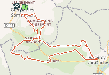
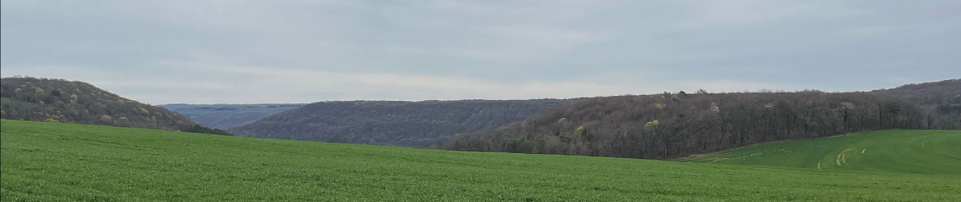
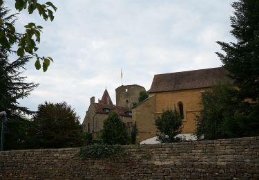
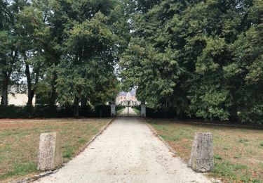
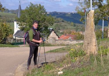
Ruta Senderismo de 14 km a descubrir en Borgoña-Franco Condado, Côte-d'Or, Grenant-lès-Sombernon. Esta ruta ha sido propuesta por eric.guyard21.
Descripción
Randonnée, pas trop difficile, beaucoup de monter en fin de rando, pas mal de choses à voire
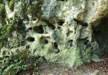
Localización
País:
France
Región :
Borgoña-Franco Condado
Departamento/provincia :
Côte-d'Or
Municipio :
Grenant-lès-Sombernon
Localidad:
Unknown
Salida:(Dec)
Salida:(UTM)
629419 ; 5236668 (31T) N.
Comentarios
Excursiones cerca
![Excursión Senderismo Barbirey-sur-Ouche - Le Tour de Barbiriacum - Barbirey sur Ouche - Photo](https://media.geolcdn.com/t/375/260/ext.jpg?maxdim=2&url=https%3A%2F%2Fservices.sitytrail.com%2FGeolivesWS%2FDownloadMedia.ashx%3FTrailID%3D104688%26Media%3D8091_1.jpg)
![Senderismo Senderismo](https://static1.geolcdn.com/sitytour/trail-icons/101.png)
Le Tour de Barbiriacum - Barbirey sur Ouche
Senderismo
Medio
(1)
Barbirey-sur-Ouche,
Borgoña-Franco Condado,
Côte-d'Or,
France
![](/images/other/stat-length.png)
10,5 km | 15,9 km-effort
2h 45min
![](https://static1.geolcdn.com/siteimages/upload/files/16400158638029165_repeat_loop_refresh_sync_direction_icon.png)
Sí
![Excursión A pie Montoillot - Boucle des Trois Châteaux - Photo](https://media.geolcdn.com/t/375/260/ext.jpg?maxdim=2&url=https%3A%2F%2Fmedia.geolcdn.com%2Ff%2F2cd4cd43-eb70-46bd-8967-9dc616d3cc69.jpeg)
![A pie A pie](https://static1.geolcdn.com/sitytour/trail-icons/100.png)
Boucle des Trois Châteaux
A pie
Fácil
Montoillot,
Borgoña-Franco Condado,
Côte-d'Or,
France
![](/images/other/stat-length.png)
8,6 km | 11,1 km-effort
2h 31min
![](https://static1.geolcdn.com/siteimages/upload/files/16400158638029165_repeat_loop_refresh_sync_direction_icon.png)
No
![Excursión Bici de montaña Montoillot - Les trois châteaux 2018.08.27 - Photo](https://media.geolcdn.com/t/375/260/ext.jpg?maxdim=2&url=https%3A%2F%2Fservices.sitytrail.com%2FGeolivesWS%2FDownloadMedia.ashx%3FTrailID%3D1029771%26Media%3D20180827131143.jpg)
![Bici de montaña Bici de montaña](https://static1.geolcdn.com/sitytour/trail-icons/202.png)
Les trois châteaux 2018.08.27
Bici de montaña
Medio
Montoillot,
Borgoña-Franco Condado,
Côte-d'Or,
France
![](/images/other/stat-length.png)
21 km | 25 km-effort
1h 47min
![](https://static1.geolcdn.com/siteimages/upload/files/16400158638029165_repeat_loop_refresh_sync_direction_icon.png)
Sí
![Excursión Bici de montaña Montoillot - Les trois châteaux 2018.08.27 - Photo](https://media.geolcdn.com/t/375/260/ext.jpg?maxdim=2&url=https%3A%2F%2Fservices.sitytrail.com%2FGeolivesWS%2FDownloadMedia.ashx%3FTrailID%3D1029756%26Media%3D20180827131143.jpg)
![Bici de montaña Bici de montaña](https://static1.geolcdn.com/sitytour/trail-icons/202.png)
Les trois châteaux 2018.08.27
Bici de montaña
Medio
Montoillot,
Borgoña-Franco Condado,
Côte-d'Or,
France
![](/images/other/stat-length.png)
21 km | 25 km-effort
1h 47min
![](https://static1.geolcdn.com/siteimages/upload/files/16400158638029165_repeat_loop_refresh_sync_direction_icon.png)
Sí
![Excursión Senderismo Barbirey-sur-Ouche - Tebzima - Photo](https://media.geolcdn.com/t/375/260/ext.jpg?maxdim=2&url=https%3A%2F%2Fservices.sitytrail.com%2FGeolivesWS%2FDownloadMedia.ashx%3FTrailID%3D1013095%26Media%3D20180730104607.jpg)
![Senderismo Senderismo](https://static1.geolcdn.com/sitytour/trail-icons/101.png)
Tebzima
Senderismo
Medio
Barbirey-sur-Ouche,
Borgoña-Franco Condado,
Côte-d'Or,
France
![](/images/other/stat-length.png)
13,4 km | 20 km-effort
4h 11min
![](https://static1.geolcdn.com/siteimages/upload/files/16400158638029165_repeat_loop_refresh_sync_direction_icon.png)
Sí
![Excursión A pie Barbirey-sur-Ouche - barbirey - Photo](https://media.geolcdn.com/t/375/260/ext.jpg?maxdim=2&url=https%3A%2F%2Fmedia.geolcdn.com%2Ff%2Fd6bd1c62-1edb-4936-a48f-393652ec8299.jpg)
![A pie A pie](https://static1.geolcdn.com/sitytour/trail-icons/100.png)
barbirey
A pie
Medio
Barbirey-sur-Ouche,
Borgoña-Franco Condado,
Côte-d'Or,
France
![](/images/other/stat-length.png)
15,5 km | 23 km-effort
2min
![](https://static1.geolcdn.com/siteimages/upload/files/16400158638029165_repeat_loop_refresh_sync_direction_icon.png)
Sí
![Excursión Bici de montaña Montoillot - Les trois cha^teaux 2018.08.27 - Photo](https://media.geolcdn.com/t/375/260/ext.jpg?maxdim=2&url=https%3A%2F%2Fservices.sitytrail.com%2FGeolivesWS%2FDownloadMedia.ashx%3FTrailID%3D1029723%26Media%3D20180827131143.jpg)
![Bici de montaña Bici de montaña](https://static1.geolcdn.com/sitytour/trail-icons/202.png)
Les trois cha^teaux 2018.08.27
Bici de montaña
Fácil
Montoillot,
Borgoña-Franco Condado,
Côte-d'Or,
France
![](/images/other/stat-length.png)
22 km | 27 km-effort
1h 47min
![](https://static1.geolcdn.com/siteimages/upload/files/16400158638029165_repeat_loop_refresh_sync_direction_icon.png)
Sí
![Excursión Senderismo Barbirey-sur-Ouche - barbirey sur Ouche - Photo](https://media.geolcdn.com/t/375/260/ext.jpg?maxdim=2&url=https%3A%2F%2Fstatic1.geolcdn.com%2Fsiteimages%2Fupload%2Ffiles%2F1553511878bg_sport_marche.png)
![Senderismo Senderismo](https://static1.geolcdn.com/sitytour/trail-icons/101.png)
barbirey sur Ouche
Senderismo
Medio
Barbirey-sur-Ouche,
Borgoña-Franco Condado,
Côte-d'Or,
France
![](/images/other/stat-length.png)
19,4 km | 28 km-effort
6h 59min
![](https://static1.geolcdn.com/siteimages/upload/files/16400158638029165_repeat_loop_refresh_sync_direction_icon.png)
No
![Excursión Senderismo Montoillot - la boucle des 3 châteaux en auxois (Dijon) - Photo](https://media.geolcdn.com/t/375/260/ext.jpg?maxdim=2&url=https%3A%2F%2Fstatic1.geolcdn.com%2Fsiteimages%2Fupload%2Ffiles%2F1553511878bg_sport_marche.png)
![Senderismo Senderismo](https://static1.geolcdn.com/sitytour/trail-icons/101.png)
la boucle des 3 châteaux en auxois (Dijon)
Senderismo
Muy difícil
Montoillot,
Borgoña-Franco Condado,
Côte-d'Or,
France
![](/images/other/stat-length.png)
17,9 km | 22 km-effort
5h 1min
![](https://static1.geolcdn.com/siteimages/upload/files/16400158638029165_repeat_loop_refresh_sync_direction_icon.png)
Sí