![](/images/other/stat-length.png)
![Excursión Senderismo Plainfaing - Calvaire-Schlucht-Calvaire - Photo](https://media.geolcdn.com/t/1900/400/ext.pjpeg?maxdim=2&url=https%3A%2F%2Fstatic1.geolcdn.com%2Fsiteimages%2Fupload%2Ffiles%2F1553511878bg_sport_marche.png)
Calvaire-Schlucht-Calvaire
Schnacka
Usuario
![Longitud](/images/other/stat-length.png)
Longitud
22 km
![Altitud máxima](https://static1.geolcdn.com/siteimages/upload/files/1508320355ic_sort_altitude_max_24dp.png)
Altitud máxima
1304 m
![Desnivel positivo](https://static1.geolcdn.com/siteimages/upload/files/1508320355ic_sort_den_pos_24dp.png)
Desnivel positivo
625 m
![Km-Effort](/images/other/stat-length.png)
Km-Effort
30 km
![Altitud mínima](https://static1.geolcdn.com/siteimages/upload/files/1508320355ic_sort_altitude_min_24dp.png)
Altitud mínima
1137 m
![Desnivel negativo](https://static1.geolcdn.com/siteimages/upload/files/1508320355ic_sort_den_neg_24dp.png)
Desnivel negativo
626 m
![Boucle](https://static1.geolcdn.com/siteimages/upload/files/16400158638029165_repeat_loop_refresh_sync_direction_icon.png)
Boucle
Sí
Fecha de creación :
2017-08-26 00:00:00.0
Última modificación :
2017-08-26 00:00:00.0
![Senderismo](https://static1.geolcdn.com/sitytour/trail-icons/101.png)
7h01
Dificultad : Medio
![Escanee este código QR para abrir la excursión en la aplicación SityTrail](https://capi.geolives.com/qq0zvz2zws4bq2lad0pu/sitytour/trails/810709/qr.png?size=200)
Aplicación GPS de excursión GRATIS
A propósito
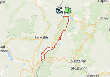
Ruta Senderismo de 22 km a descubrir en Gran Este, Vosgos, Plainfaing. Esta ruta ha sido propuesta por Schnacka.
Descripción
Randonnée assez longue mais sans grande difficulté. Peut éventuellement être réduite de moitié les dimanches d'été en prenant la navette des crêts pour le retour de la Schlucht au Calvaire (vérifier si elle est en service!)
Localización
País:
France
Región :
Gran Este
Departamento/provincia :
Vosgos
Municipio :
Plainfaing
Localidad:
Unknown
Salida:(Dec)
Salida:(UTM)
356597 ; 5332335 (32U) N.
Comentarios
Excursiones cerca
![Excursión Paseo ecuestre Orbey - 2020-06-28 WE Orbey Petit Hohnack Glasborn - Photo](https://media.geolcdn.com/t/375/260/ext.jpg?maxdim=2&url=https%3A%2F%2Fmedia.geolcdn.com%2Ff%2Fef012c2d-591e-4a7a-ae45-376661550d14.jpg)
![Paseo ecuestre Paseo ecuestre](https://static1.geolcdn.com/sitytour/trail-icons/301.png)
2020-06-28 WE Orbey Petit Hohnack Glasborn
Paseo ecuestre
Difícil
(1)
Orbey,
Gran Este,
Alto Rin,
France
![](/images/other/stat-length.png)
22 km | 31 km-effort
4h 5min
![](https://static1.geolcdn.com/siteimages/upload/files/16400158638029165_repeat_loop_refresh_sync_direction_icon.png)
Sí
![Excursión Paseo ecuestre Orbey - 2020-06-27 WE Orbey Noir Gazon Vert Forlet - Photo](https://media.geolcdn.com/t/375/260/ext.jpg?maxdim=2&url=https%3A%2F%2Fmedia.geolcdn.com%2Ff%2Ff691f0a3-eb26-4898-acd3-19530bfd0b6d.jpg)
![Paseo ecuestre Paseo ecuestre](https://static1.geolcdn.com/sitytour/trail-icons/301.png)
2020-06-27 WE Orbey Noir Gazon Vert Forlet
Paseo ecuestre
Medio
(1)
Orbey,
Gran Este,
Alto Rin,
France
![](/images/other/stat-length.png)
21 km | 30 km-effort
3h 59min
![](https://static1.geolcdn.com/siteimages/upload/files/16400158638029165_repeat_loop_refresh_sync_direction_icon.png)
Sí
![Excursión Otra actividad Soultzeren - Totom 4 lacs - Photo](https://media.geolcdn.com/t/375/260/ext.jpg?maxdim=2&url=https%3A%2F%2Fservices.sitytrail.com%2FGeolivesWS%2FDownloadMedia.ashx%3FTrailID%3D789048%26Media%3D20170713134427.jpg)
![Otra actividad Otra actividad](https://static1.geolcdn.com/sitytour/trail-icons/900.png)
Totom 4 lacs
Otra actividad
Medio
(1)
Soultzeren,
Gran Este,
Alto Rin,
France
![](/images/other/stat-length.png)
15,6 km | 26 km-effort
4h 37min
![](https://static1.geolcdn.com/siteimages/upload/files/16400158638029165_repeat_loop_refresh_sync_direction_icon.png)
Sí
![Excursión Senderismo Orbey - Le Tour du Lac Blanc par le Rocher Hans et le sentier de crête - Photo](https://media.geolcdn.com/t/375/260/ext.jpg?maxdim=2&url=https%3A%2F%2Fservices.sitytrail.com%2FGeolivesWS%2FDownloadMedia.ashx%3FTrailID%3D112616%26Media%3D11189_5.jpg)
![Senderismo Senderismo](https://static1.geolcdn.com/sitytour/trail-icons/101.png)
Le Tour du Lac Blanc par le Rocher Hans et le sentier de crête
Senderismo
Difícil
(3)
Orbey,
Gran Este,
Alto Rin,
France
![](/images/other/stat-length.png)
4,4 km | 7,7 km-effort
2h 30min
![](https://static1.geolcdn.com/siteimages/upload/files/16400158638029165_repeat_loop_refresh_sync_direction_icon.png)
Sí
![Excursión Senderismo Le Bonhomme - Tête des faux . - Photo](https://media.geolcdn.com/t/375/260/ext.jpg?maxdim=2&url=https%3A%2F%2Fmedia.geolcdn.com%2Ff%2F84fec98d-7f8b-4bf8-a434-52c0363ad440.jpg)
![Senderismo Senderismo](https://static1.geolcdn.com/sitytour/trail-icons/101.png)
Tête des faux .
Senderismo
Medio
(1)
Le Bonhomme,
Gran Este,
Alto Rin,
France
![](/images/other/stat-length.png)
11,9 km | 16,6 km-effort
3h 46min
![](https://static1.geolcdn.com/siteimages/upload/files/16400158638029165_repeat_loop_refresh_sync_direction_icon.png)
Sí
![Excursión Senderismo Soultzeren - Tanet-Gazon du faing par lac vert et retour sommet du Tanet - Photo](https://media.geolcdn.com/t/375/260/ext.jpg?maxdim=2&url=https%3A%2F%2Fmedia.geolcdn.com%2Ff%2Fed68be74-246f-440b-833e-a0b4a96a4c20.jpg)
![Senderismo Senderismo](https://static1.geolcdn.com/sitytour/trail-icons/101.png)
Tanet-Gazon du faing par lac vert et retour sommet du Tanet
Senderismo
Medio
(1)
Soultzeren,
Gran Este,
Alto Rin,
France
![](/images/other/stat-length.png)
10 km | 15,6 km-effort
4h 24min
![](https://static1.geolcdn.com/siteimages/upload/files/16400158638029165_repeat_loop_refresh_sync_direction_icon.png)
Sí
![Excursión Bici de montaña Orbey - Lac Blanc - Têtes des Faux - Photo](https://media.geolcdn.com/t/375/260/ext.jpg?maxdim=2&url=https%3A%2F%2Fservices.sitytrail.com%2FGeolivesWS%2FDownloadMedia.ashx%3FTrailID%3D101197%26Media%3D684_1.jpg)
![Bici de montaña Bici de montaña](https://static1.geolcdn.com/sitytour/trail-icons/202.png)
Lac Blanc - Têtes des Faux
Bici de montaña
Medio
(1)
Orbey,
Gran Este,
Alto Rin,
France
![](/images/other/stat-length.png)
15,3 km | 21 km-effort
1h 0min
![](https://static1.geolcdn.com/siteimages/upload/files/16400158638029165_repeat_loop_refresh_sync_direction_icon.png)
Sí
![Excursión Senderismo Le Bonhomme - Le Bonhomme - Circuit du village - Photo](https://media.geolcdn.com/t/375/260/ext.jpg?maxdim=2&url=https%3A%2F%2Fstatic1.geolcdn.com%2Fsiteimages%2Fupload%2Ffiles%2F1553511878bg_sport_marche.png)
![Senderismo Senderismo](https://static1.geolcdn.com/sitytour/trail-icons/101.png)
Le Bonhomme - Circuit du village
Senderismo
Fácil
(1)
Le Bonhomme,
Gran Este,
Alto Rin,
France
![](/images/other/stat-length.png)
3 km | 5,3 km-effort
1h 30min
![](https://static1.geolcdn.com/siteimages/upload/files/16400158638029165_repeat_loop_refresh_sync_direction_icon.png)
Sí
![Excursión Paseo ecuestre Orbey - gite pre au bois gazon du Faing lac blanc lac noir - Photo](https://media.geolcdn.com/t/375/260/ext.jpg?maxdim=2&url=https%3A%2F%2Fstatic1.geolcdn.com%2Fsiteimages%2Fupload%2Ffiles%2F1524743154cheval.jpg)
![Paseo ecuestre Paseo ecuestre](https://static1.geolcdn.com/sitytour/trail-icons/301.png)
gite pre au bois gazon du Faing lac blanc lac noir
Paseo ecuestre
Medio
(1)
Orbey,
Gran Este,
Alto Rin,
France
![](/images/other/stat-length.png)
17,2 km | 25 km-effort
3h 17min
![](https://static1.geolcdn.com/siteimages/upload/files/16400158638029165_repeat_loop_refresh_sync_direction_icon.png)
Sí