Val-et-Châtillon, Meurthe-et-Moselle : Les meilleures randonnées, itinéraires, parcours, balades et promenades

Val-et-Châtillon : découvrez les meilleures randonnées : 16 pédestres et 1 parcours équestres. Tous ces circuits, parcours, itinéraires et activités en plein air sont disponibles dans nos applications SityTrail pour smartphones et tablettes.


Les meilleurs parcours (17)

Randonnée Marche Val-et-Châtillon - val et Chatillon  - Photo
Marche 12.609
Km

Marche

Facile
Val-et-Châtillon, Grand Est, Meurthe-et-Moselle, France
12,6 km | 16,6 km-effort
2h 9min
295 m
300 m
Oui
gervaisgilles

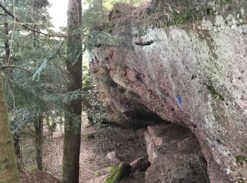
• Croix COLIN et roche des Druides

Randonnée Marche Val-et-Châtillon - val et chatillon - Photo
Marche 19.333
Km

Marche

Moyen
Val-et-Châtillon, Grand Est, Meurthe-et-Moselle, France
19,3 km | 26 km-effort
6h 37min
496 m
494 m
Oui
sruquarante

Randonnée Marche Val-et-Châtillon - Croix Klopstein-Grand Rougimont - Photo
Marche 17.319
Km

Marche

Moyen
Val-et-Châtillon, Grand Est, Meurthe-et-Moselle, France
17,3 km | 24 km-effort
4h 7min
512 m
511 m
Oui
edouard_bieber

• 23.04.2019

Randonnée Marche Val-et-Châtillon - Saint Sauveur - Photo
Marche 17.765
Km

Marche

Moyen
Val-et-Châtillon, Grand Est, Meurthe-et-Moselle, France
17,8 km | 24 km-effort
3h 55min
480 m
478 m
Oui
edouard_bieber

• 13.06.2017

Randonnée Marche Val-et-Châtillon - Les roches d'Aschiffet - Photo
Marche 7.448
Km

Marche

Facile
Val-et-Châtillon, Grand Est, Meurthe-et-Moselle, France
7,4 km | 9,7 km-effort
1h 50min
172 m
172 m
Oui
edouard_bieber

• 20.12.2016

Randonnée Marche Val-et-Châtillon - Val et Chatillon - Photo
Marche 23.136
Km

Marche

Moyen
Val-et-Châtillon, Grand Est, Meurthe-et-Moselle, France
23 km | 31 km-effort
6h 34min
615 m
619 m
Oui
edouard_bieber

• 13.03.2014

Randonnée Marche Val-et-Châtillon - Châtillon - Photo
Marche 23.402
Km

Marche

Difficile
Val-et-Châtillon, Grand Est, Meurthe-et-Moselle, France
23 km | 31 km-effort
6h 15min
592 m
592 m
Oui
MMarie

Randonnée Marche Val-et-Châtillon - Châtillon-les Rougimonts - Photo
Marche 23.402
Km

Marche

Difficile
Val-et-Châtillon, Grand Est, Meurthe-et-Moselle, France
23 km | 31 km-effort
6h 15min
592 m
592 m
Oui
MMarie

• Selon le topo guide "La Lorraine à pied" (N°10) Dernière partie (Roche des Druides) non effectuée du fait des restric...

Randonnée Marche Val-et-Châtillon - Grand Rougimont - Photo
Marche 18.904
Km

Marche

Moyen
Val-et-Châtillon, Grand Est, Meurthe-et-Moselle, France
18,9 km | 28 km-effort
6h 0min
648 m
647 m
Oui
claudemoret

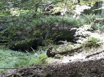
• Rando de difficulté facile à moyenne suivant niveau du marcheur. Belles roches. Beaucoup à couvert.

Randonnée Marche Val-et-Châtillon - Val et Chatillon - Photo
Marche 10.013
Km

Marche

Difficile
Val-et-Châtillon, Grand Est, Meurthe-et-Moselle, France
10 km | 13,8 km-effort
3h 25min
283 m
280 m
Oui
Pascal Raon

Randonnée Trail Val-et-Châtillon - grand et petit rougimont - Photo
Trail 20.388
Km

Trail

Moyen
Val-et-Châtillon, Grand Est, Meurthe-et-Moselle, France
20 km | 28 km-effort
Inconnu
553 m
549 m
Oui
Titinechris

Randonnée Randonnée équestre Val-et-Châtillon - randonnée val et chatillon - Photo
Randonnée équestre 14.047
Km

Randonnée équestre

Moyen
Val-et-Châtillon, Grand Est, Meurthe-et-Moselle, France
14 km | 19,9 km-effort
3h 30min
439 m
424 m
Oui
ACPL

Randonnée Marche Val-et-Châtillon - Val - Photo
Marche 17.454
Km

Marche

Très difficile
Val-et-Châtillon, Grand Est, Meurthe-et-Moselle, France
17,5 km | 23 km-effort
5h 17min
383 m
383 m
Oui
audrey54

Randonnée Marche Val-et-Châtillon - Val auge val par gros chêne  - Photo
Marche 19.49
Km

Marche

Très difficile
Val-et-Châtillon, Grand Est, Meurthe-et-Moselle, France
19,5 km | 27 km-effort
4h 10min
594 m
599 m
Non
audrey54

Randonnée Trail Val-et-Châtillon - dimanche 19 sep tomtom7 - Photo
Trail 22.987
Km

Trail

Facile
Val-et-Châtillon, Grand Est, Meurthe-et-Moselle, France
23 km | 33 km-effort
3h 59min
777 m
772 m
Oui
Titinechris

Randonnée Marche Val-et-Châtillon - Tour de la soie à pied - Photo
Marche 9.278
Km

Marche

Difficile
Val-et-Châtillon, Grand Est, Meurthe-et-Moselle, France
9,3 km | 12,7 km-effort
1h 54min
259 m
252 m
Oui
audrey54

Randonnée Marche Val-et-Châtillon - Val corbet  - Photo
Marche 18.263
Km

Marche

Difficile
Val-et-Châtillon, Grand Est, Meurthe-et-Moselle, France
18,3 km | 23 km-effort
5h 45min
296 m
445 m
Non
audrey54

17 randonnées affichées sur 17

Application GPS de randonnée GRATUITE

Logo SityTrail SityTrail

IGN / Instituts géographiques

Télécharger SityTrail sur l'App Store Télécharger SityTrail sur Google Play

Logo SityTrail SityTrail World

Le monde est à vous

Télécharger SityTrail sur l'App Store Télécharger SityTrail sur Google Play Télécharger SityTrail sur Huawei AppGallery

Activités

Fermer
Mes abonnements