


38 km | 52 km-effort
Nans-les-Pins : découvrez les meilleures randonnées : 4 v.t.t. et 1 vélo électrique. Tous ces circuits, parcours, itinéraires et activités en plein air sont disponibles dans nos applications SityTrail pour smartphones et tablettes.

V.T.T.


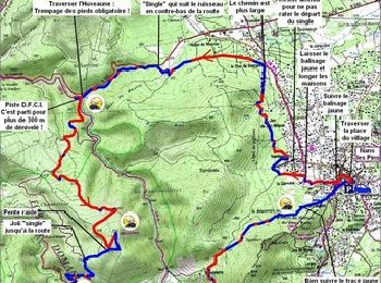
• randonnée VTT très difficile car beaucoup de single technique autant à la montée qu'à la descente point sinon un parc...
V.T.T.
• Très joli parcours qui fait la part belle aux "single tracks". Si on peut y venir en toute saison, je pense qu'il vau...

V.T.T.
• randonnée VTT très difficile car beaucoup de single technique autant à la montée qu'à la descente point sinon un parc...
Vélo électrique
V.T.T.
5 randonnées affichées sur 5
Application GPS de randonnée GRATUITE
 SityTrail
IGN / Instituts géographiques
SityTrail World
Le monde est à vous