![](/images/other/stat-length.png)
Cher, Centre-Val de Loire, Vélo : Les meilleures randonnées, itinéraires, parcours, balades et promenades
Cher : découvrez les meilleures randonnées : 27 vélo, 4 vélo de route, 101 v.t.t., 5 v.t.c., 8 cyclotourisme et 9 vélo électrique. Tous ces circuits, parcours, itinéraires et activités en plein air sont disponibles dans nos applications SityTrail pour smartphones et tablettes.
Les meilleurs parcours (152)
![Randonnée V.T.T. Veaugues - Tour de Sancerre - Photo](https://media.geolcdn.com/t/350/260/ext.jpg?maxdim=2&url=https%3A%2F%2Fservices.sitytrail.com%2FGeolivesWS%2FDownloadMedia.ashx%3FTrailID%3D102618%26Media%3D3557_5.jpg)
![V.T.T. V.T.T.](https://static1.geolcdn.com/sitytour/trail-icons/202.png)
Km
V.T.T.
![](/images/other/stat-length.png)
![](https://static1.geolcdn.com/siteimages/upload/files/1508320355ic_sort_den_pos_24dp.png)
![](https://static1.geolcdn.com/siteimages/upload/files/1508320355ic_sort_den_neg_24dp.png)
![](https://static1.geolcdn.com/siteimages/upload/files/16400158638029165_repeat_loop_refresh_sync_direction_icon.png)
• Début assez tranquille sur 6 / 8 km roulants, puis les coteaux de vignes qui montent, les sous bois, les panoramas, L...
![Randonnée Vélo Cuffy - Loire à vélo 4 - Photo](https://media.geolcdn.com/t/350/260/ext.jpg?maxdim=2&url=https%3A%2F%2Fstatic1.geolcdn.com%2Fsiteimages%2Fupload%2Ffiles%2F1524743154velo.jpg)
![Vélo Vélo](https://static1.geolcdn.com/sitytour/trail-icons/200.png)
Km
Vélo
![](/images/other/stat-length.png)
![](https://static1.geolcdn.com/siteimages/upload/files/1508320355ic_sort_den_pos_24dp.png)
![](https://static1.geolcdn.com/siteimages/upload/files/1508320355ic_sort_den_neg_24dp.png)
![](https://static1.geolcdn.com/siteimages/upload/files/16400158638029165_repeat_loop_refresh_sync_direction_icon.png)
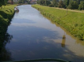
• De Cuffy à la gare de La Guerche (18)
![Randonnée V.T.T. Charenton-du-Cher - La rigole - Photo](https://media.geolcdn.com/t/350/260/ext.jpg?maxdim=2&url=https%3A%2F%2Fmedia.geolcdn.com%2Ff%2F50dae8e0-5847-4599-96eb-b41139a94f39.jpg)
![V.T.T. V.T.T.](https://static1.geolcdn.com/sitytour/trail-icons/202.png)
Km
V.T.T.
![](/images/other/stat-length.png)
![](https://static1.geolcdn.com/siteimages/upload/files/1508320355ic_sort_den_pos_24dp.png)
![](https://static1.geolcdn.com/siteimages/upload/files/1508320355ic_sort_den_neg_24dp.png)
![](https://static1.geolcdn.com/siteimages/upload/files/16400158638029165_repeat_loop_refresh_sync_direction_icon.png)
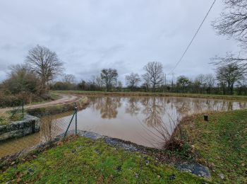
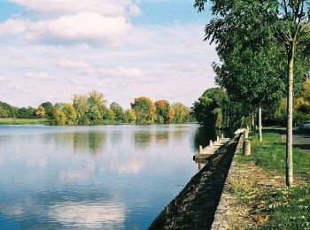
• De Fontblisse à l'étang de Goule. A la recherche des vestiges de la rigole qui alimentait le Canal du Berry pour sout...
![Randonnée V.T.C. Orval - saint amand montrond vallon - Photo](https://media.geolcdn.com/t/350/260/ext.jpg?maxdim=2&url=https%3A%2F%2Fmedia.geolcdn.com%2Ff%2F5cf692ca-e49d-4db0-8b2d-3b5da493aa1d.jpg)
![V.T.C. V.T.C.](https://static1.geolcdn.com/sitytour/trail-icons/203.png)
Km
V.T.C.
![](/images/other/stat-length.png)
![](https://static1.geolcdn.com/siteimages/upload/files/1508320355ic_sort_den_pos_24dp.png)
![](https://static1.geolcdn.com/siteimages/upload/files/1508320355ic_sort_den_neg_24dp.png)
![](https://static1.geolcdn.com/siteimages/upload/files/16400158638029165_repeat_loop_refresh_sync_direction_icon.png)
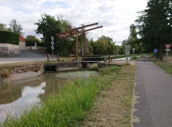
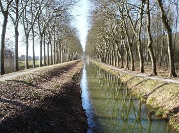
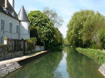
• le long du canal du Berry sur voie verte
![Randonnée V.T.T. Saint-Germain-des-Bois - foret 45km - Photo](https://media.geolcdn.com/t/350/260/ext.jpg?maxdim=2&url=https%3A%2F%2Fstatic1.geolcdn.com%2Fsiteimages%2Fupload%2Ffiles%2F1524743154velo.jpg)
![V.T.T. V.T.T.](https://static1.geolcdn.com/sitytour/trail-icons/202.png)
Km
V.T.T.
![](/images/other/stat-length.png)
![](https://static1.geolcdn.com/siteimages/upload/files/1508320355ic_sort_den_pos_24dp.png)
![](https://static1.geolcdn.com/siteimages/upload/files/1508320355ic_sort_den_neg_24dp.png)
![](https://static1.geolcdn.com/siteimages/upload/files/16400158638029165_repeat_loop_refresh_sync_direction_icon.png)
![Randonnée V.T.T. Saint-Germain-des-Bois - foret de saint germain des bois - Photo](https://media.geolcdn.com/t/350/260/ext.jpg?maxdim=2&url=https%3A%2F%2Fstatic1.geolcdn.com%2Fsiteimages%2Fupload%2Ffiles%2F1524743154velo.jpg)
![V.T.T. V.T.T.](https://static1.geolcdn.com/sitytour/trail-icons/202.png)
Km
V.T.T.
![](/images/other/stat-length.png)
![](https://static1.geolcdn.com/siteimages/upload/files/1508320355ic_sort_den_pos_24dp.png)
![](https://static1.geolcdn.com/siteimages/upload/files/1508320355ic_sort_den_neg_24dp.png)
![](https://static1.geolcdn.com/siteimages/upload/files/16400158638029165_repeat_loop_refresh_sync_direction_icon.png)
![Randonnée V.T.T. Saint-Éloy-de-Gy - Forêt d'Allogny - Photo](https://media.geolcdn.com/t/350/260/ext.jpg?maxdim=2&url=https%3A%2F%2Fstatic1.geolcdn.com%2Fsiteimages%2Fupload%2Ffiles%2F1524743154velo.jpg)
![V.T.T. V.T.T.](https://static1.geolcdn.com/sitytour/trail-icons/202.png)
Km
V.T.T.
![](/images/other/stat-length.png)
![](https://static1.geolcdn.com/siteimages/upload/files/1508320355ic_sort_den_pos_24dp.png)
![](https://static1.geolcdn.com/siteimages/upload/files/1508320355ic_sort_den_neg_24dp.png)
![](https://static1.geolcdn.com/siteimages/upload/files/16400158638029165_repeat_loop_refresh_sync_direction_icon.png)
![Randonnée V.T.T. Les Aix-d'Angillon - Menetou - Sancerroise - 1ère édition Juillet 2010 - Photo](https://media.geolcdn.com/t/350/260/ext.jpg?maxdim=2&url=https%3A%2F%2Fservices.sitytrail.com%2FGeolivesWS%2FDownloadMedia.ashx%3FTrailID%3D105424%26Media%3D9155_5.jpg)
![V.T.T. V.T.T.](https://static1.geolcdn.com/sitytour/trail-icons/202.png)
Km
V.T.T.
![](/images/other/stat-length.png)
![](https://static1.geolcdn.com/siteimages/upload/files/1508320355ic_sort_den_pos_24dp.png)
![](https://static1.geolcdn.com/siteimages/upload/files/1508320355ic_sort_den_neg_24dp.png)
![](https://static1.geolcdn.com/siteimages/upload/files/16400158638029165_repeat_loop_refresh_sync_direction_icon.png)
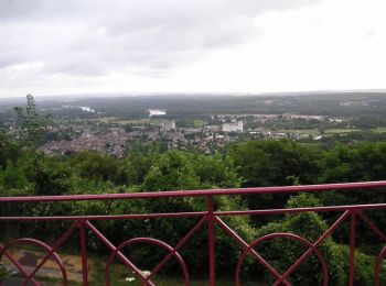
• Entre Bourges et Sancerre, cette randonnée est idéalement située au centre de la France, et vous fera découvrir une r...
![Randonnée V.T.T. Bourges - Bourges (18) - Breurey lès Faverney (70) - Etape 1/6 - De Bourges à Nevers - Photo](https://media.geolcdn.com/t/350/260/ext.jpg?maxdim=2&url=https%3A%2F%2Fservices.sitytrail.com%2FGeolivesWS%2FDownloadMedia.ashx%3FTrailID%3D104576%26Media%3D7967_4.jpg)
![V.T.T. V.T.T.](https://static1.geolcdn.com/sitytour/trail-icons/202.png)
Km
V.T.T.
![](/images/other/stat-length.png)
![](https://static1.geolcdn.com/siteimages/upload/files/1508320355ic_sort_den_pos_24dp.png)
![](https://static1.geolcdn.com/siteimages/upload/files/1508320355ic_sort_den_neg_24dp.png)
![](https://static1.geolcdn.com/siteimages/upload/files/16400158638029165_repeat_loop_refresh_sync_direction_icon.png)
• Découverte du canal de Berry, traversée du champ de tir avec ses chevreuils et sangliers.(IMPORTANT:Consulter son acc...
![Randonnée Vélo Ménétréol-sous-Sancerre - 2010-07-04 - 17h09m03 - Photo](https://media.geolcdn.com/t/350/260/ext.jpg?maxdim=2&url=https%3A%2F%2Fservices.sitytrail.com%2FGeolivesWS%2FDownloadMedia.ashx%3FTrailID%3D40521%26Media%3Dimage3.jpg)
![Vélo Vélo](https://static1.geolcdn.com/sitytour/trail-icons/200.png)
Km
Vélo
![](/images/other/stat-length.png)
![](https://static1.geolcdn.com/siteimages/upload/files/1508320355ic_sort_den_pos_24dp.png)
![](https://static1.geolcdn.com/siteimages/upload/files/1508320355ic_sort_den_neg_24dp.png)
![](https://static1.geolcdn.com/siteimages/upload/files/16400158638029165_repeat_loop_refresh_sync_direction_icon.png)
•
![Randonnée V.T.T. Brinon-sur-Sauldre - Sologne balade VTT domaine des bulles - Photo](https://media.geolcdn.com/t/350/260/ext.jpg?maxdim=2&url=https%3A%2F%2Fmedia.geolcdn.com%2Ff%2Fc662ecc2-3a31-469f-97c0-9a2b8a1fafad.jpg)
![V.T.T. V.T.T.](https://static1.geolcdn.com/sitytour/trail-icons/202.png)
Km
V.T.T.
![](/images/other/stat-length.png)
![](https://static1.geolcdn.com/siteimages/upload/files/1508320355ic_sort_den_pos_24dp.png)
![](https://static1.geolcdn.com/siteimages/upload/files/1508320355ic_sort_den_neg_24dp.png)
![](https://static1.geolcdn.com/siteimages/upload/files/16400158638029165_repeat_loop_refresh_sync_direction_icon.png)
![Randonnée V.T.T. Vierzon - vz l' alouette theillay orcay vz - Photo](https://media.geolcdn.com/t/350/260/ext.jpg?maxdim=2&url=https%3A%2F%2Fservices.sitytrail.com%2FGeolivesWS%2FDownloadMedia.ashx%3FTrailID%3D737914%26Media%3Dfix__20170422172852.jpg)
![V.T.T. V.T.T.](https://static1.geolcdn.com/sitytour/trail-icons/202.png)
Km
V.T.T.
![](/images/other/stat-length.png)
![](https://static1.geolcdn.com/siteimages/upload/files/1508320355ic_sort_den_pos_24dp.png)
![](https://static1.geolcdn.com/siteimages/upload/files/1508320355ic_sort_den_neg_24dp.png)
![](https://static1.geolcdn.com/siteimages/upload/files/16400158638029165_repeat_loop_refresh_sync_direction_icon.png)
![Randonnée V.T.T. Morogues - De Morogues à La Borne - Photo](https://media.geolcdn.com/t/350/260/ext.jpg?maxdim=2&url=https%3A%2F%2Fservices.sitytrail.com%2FGeolivesWS%2FDownloadMedia.ashx%3FTrailID%3D317489%26Media%3D16722_1.jpg)
![V.T.T. V.T.T.](https://static1.geolcdn.com/sitytour/trail-icons/202.png)
Km
V.T.T.
![](/images/other/stat-length.png)
![](https://static1.geolcdn.com/siteimages/upload/files/1508320355ic_sort_den_pos_24dp.png)
![](https://static1.geolcdn.com/siteimages/upload/files/1508320355ic_sort_den_neg_24dp.png)
![](https://static1.geolcdn.com/siteimages/upload/files/16400158638029165_repeat_loop_refresh_sync_direction_icon.png)
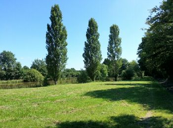
• Terrain assez gras en hiver. Des paysages superbes entre vignoble et pommiers.
![Randonnée V.T.T. Blancafort - Le Canal de la Sauldre - Blancafort - Photo](https://media.geolcdn.com/t/350/260/ext.jpg?maxdim=2&url=https%3A%2F%2Fservices.sitytrail.com%2FGeolivesWS%2FDownloadMedia.ashx%3FTrailID%3D316757%26Media%3D4668_1.jpg)
![V.T.T. V.T.T.](https://static1.geolcdn.com/sitytour/trail-icons/202.png)
Km
V.T.T.
![](/images/other/stat-length.png)
![](https://static1.geolcdn.com/siteimages/upload/files/1508320355ic_sort_den_pos_24dp.png)
![](https://static1.geolcdn.com/siteimages/upload/files/1508320355ic_sort_den_neg_24dp.png)
![](https://static1.geolcdn.com/siteimages/upload/files/16400158638029165_repeat_loop_refresh_sync_direction_icon.png)
• Ce tronçon isolé de 45km conserve le charme suranné des projets démesurés d’aménagements fonciers du XIXè siècle, et ...
![Randonnée V.T.T. Châteauneuf-sur-Cher - Le Cher majestueux à Châteauneuf sur Cher - Photo](https://media.geolcdn.com/t/350/260/ext.jpg?maxdim=2&url=https%3A%2F%2Fservices.sitytrail.com%2FGeolivesWS%2FDownloadMedia.ashx%3FTrailID%3D316754%26Media%3D4667_1.jpg)
![V.T.T. V.T.T.](https://static1.geolcdn.com/sitytour/trail-icons/202.png)
Km
V.T.T.
![](/images/other/stat-length.png)
![](https://static1.geolcdn.com/siteimages/upload/files/1508320355ic_sort_den_pos_24dp.png)
![](https://static1.geolcdn.com/siteimages/upload/files/1508320355ic_sort_den_neg_24dp.png)
![](https://static1.geolcdn.com/siteimages/upload/files/16400158638029165_repeat_loop_refresh_sync_direction_icon.png)
• A Châteauneuf sur Cher, vous vous approcherez d'une rivière qui a su garder un caractère authentiquement sauvage. Peu...
![Randonnée V.T.T. Lignières - Lignières - Photo](https://media.geolcdn.com/t/350/260/ext.jpg?maxdim=2&url=https%3A%2F%2Fservices.sitytrail.com%2FGeolivesWS%2FDownloadMedia.ashx%3FTrailID%3D201679%26Media%3Dfix__20130630110839.jpg)
![V.T.T. V.T.T.](https://static1.geolcdn.com/sitytour/trail-icons/202.png)
Km
V.T.T.
![](/images/other/stat-length.png)
![](https://static1.geolcdn.com/siteimages/upload/files/1508320355ic_sort_den_pos_24dp.png)
![](https://static1.geolcdn.com/siteimages/upload/files/1508320355ic_sort_den_neg_24dp.png)
![](https://static1.geolcdn.com/siteimages/upload/files/16400158638029165_repeat_loop_refresh_sync_direction_icon.png)
• Rando VTT boulot
![Randonnée V.T.T. Bourges - Autour de Bourges - Photo](https://media.geolcdn.com/t/350/260/ext.jpg?maxdim=2&url=https%3A%2F%2Fservices.sitytrail.com%2FGeolivesWS%2FDownloadMedia.ashx%3FTrailID%3D106680%26Media%3D11307_1.jpg)
![V.T.T. V.T.T.](https://static1.geolcdn.com/sitytour/trail-icons/202.png)
Km
V.T.T.
![](/images/other/stat-length.png)
![](https://static1.geolcdn.com/siteimages/upload/files/1508320355ic_sort_den_pos_24dp.png)
![](https://static1.geolcdn.com/siteimages/upload/files/1508320355ic_sort_den_neg_24dp.png)
![](https://static1.geolcdn.com/siteimages/upload/files/16400158638029165_repeat_loop_refresh_sync_direction_icon.png)
• Joli circuit, peu de relief. Quelques kilomètres sur petites routes goudronnées. Accessible à tous.
![Randonnée V.T.T. Bourges - Bourges - Canaux et chemins - Photo](https://media.geolcdn.com/t/350/260/ext.jpg?maxdim=2&url=https%3A%2F%2Fservices.sitytrail.com%2FGeolivesWS%2FDownloadMedia.ashx%3FTrailID%3D106670%26Media%3D11296_1.jpg)
![V.T.T. V.T.T.](https://static1.geolcdn.com/sitytour/trail-icons/202.png)
Km
V.T.T.
![](/images/other/stat-length.png)
![](https://static1.geolcdn.com/siteimages/upload/files/1508320355ic_sort_den_pos_24dp.png)
![](https://static1.geolcdn.com/siteimages/upload/files/1508320355ic_sort_den_neg_24dp.png)
![](https://static1.geolcdn.com/siteimages/upload/files/16400158638029165_repeat_loop_refresh_sync_direction_icon.png)
• Un circuit agréable avec plus de 90% de chemin, très peu de goudron. Passage par les canaux et les chemins.
![Randonnée Vélo de route Saint-Satur - u6 - Photo](https://media.geolcdn.com/t/350/260/ext.jpg?maxdim=2&url=https%3A%2F%2Fstatic1.geolcdn.com%2Fsiteimages%2Fupload%2Ffiles%2F1524743154velo.jpg)
![Vélo de route Vélo de route](https://static1.geolcdn.com/sitytour/trail-icons/201.png)
Km
Vélo de route
![](/images/other/stat-length.png)
![](https://static1.geolcdn.com/siteimages/upload/files/1508320355ic_sort_den_pos_24dp.png)
![](https://static1.geolcdn.com/siteimages/upload/files/1508320355ic_sort_den_neg_24dp.png)
![](https://static1.geolcdn.com/siteimages/upload/files/16400158638029165_repeat_loop_refresh_sync_direction_icon.png)
• c
![Randonnée V.T.C. Neuvy-sur-Barangeon - neuvy et forêt - Photo](https://media.geolcdn.com/t/350/260/ext.jpg?maxdim=2&url=https%3A%2F%2Fstatic1.geolcdn.com%2Fsiteimages%2Fupload%2Ffiles%2F1524743154velo.jpg)
![V.T.C. V.T.C.](https://static1.geolcdn.com/sitytour/trail-icons/203.png)
Km
V.T.C.
![](/images/other/stat-length.png)
![](https://static1.geolcdn.com/siteimages/upload/files/1508320355ic_sort_den_pos_24dp.png)
![](https://static1.geolcdn.com/siteimages/upload/files/1508320355ic_sort_den_neg_24dp.png)
![](https://static1.geolcdn.com/siteimages/upload/files/16400158638029165_repeat_loop_refresh_sync_direction_icon.png)
• Velo avec assistance, chemins de forêt et route
20 randonnées affichées sur 152
Application GPS de randonnée GRATUITE
Activités
Régions proches
- Achères
- Ainay-le-Vieil
- Allogny
- Allouis
- Annoix
- Apremont-sur-Allier
- Arçay
- Ardenais
- Argent-sur-Sauldre
- Argenvières
- Assigny
- Aubigny-sur-Nère
- Aubinges
- Augy-sur-Aubois
- Avord
- Bannay
- Bannegon
- Barlieu
- Baugy
- Beffes
- Belleville-sur-Loire
- Bengy-sur-Craon
- Berry-Bouy
- Bessais-le-Fromental
- Blancafort
- Boulleret
- Bourges
- Bouzais
- Brécy
- Brinay
- Brinon-sur-Sauldre
- Bruère-Allichamps
- Bué
- Cerbois
- Chambon
- Charenton-du-Cher
- Charly
- Chârost
- Châteaumeillant
- Châteauneuf-sur-Cher
- Chezal-Benoît
- Clémont
- Concressault
- Cornusse
- Corquoy
- Couargues
- Cours-les-Barres
- Coust
- Couy
- Crézancy-en-Sancerre
- Croisy
- Crosses
- Cuffy
- Culan
- Dampierre-en-Crot
- Dampierre-en-Graçay
- Drevant
- Dun-sur-Auron
- Ennordres
- Épineuil-le-Fleuriel
- Farges-Allichamps
- Farges-en-Septaine
- Flavigny
- Foëcy
- Fussy
- Gardefort
- Genouilly
- Givardon
- Graçay
- Grossouvre
- Henrichemont
- Herry
- Humbligny
- Ids-Saint-Roch
- Ignol
- Ivoy-le-Pré
- Jalognes
- Jars
- Jouet-sur-l'Aubois
- La Celle
- La Celle-Condé
- La Chapelle-Hugon
- La Chapelle-Montlinard
- La Chapelle-Saint-Ursin
- La Chapelle-d'Angillon
- La Chapelotte
- La Guerche-sur-l'Aubois
- La Perche
- Lapan
- Le Châtelet
- Le Noyer
- Le Subdray
- Léré
- Les Aix-d'Angillon
- Levet
- Lignières
- Loye-sur-Arnon
- Lunery
- Lury-sur-Arnon
- Maisonnais
- Marçais
- Mareuil-sur-Arnon
- Marmagne
- Marseilles-lès-Aubigny
- Massay
- Mehun-sur-Yèvre
- Meillant
- Menetou-Couture
- Menetou-Râtel
- Menetou-Salon
- Ménétréol-sous-Sancerre
- Ménétréol-sur-Sauldre
- Méreau
- Méry-ès-Bois
- Méry-sur-Cher
- Montigny
- Morlac
- Mornay-Berry
- Mornay-sur-Allier
- Morogues
- Morthomiers
- Moulins-sur-Yèvre
- Nançay
- Nérondes
- Neuilly-en-Dun
- Neuilly-en-Sancerre
- Neuvy-Deux-Clochers
- Neuvy-le-Barrois
- Neuvy-sur-Barangeon
- Nohant-en-Graçay
- Oizon
- Orcenais
- Orval
- Osmery
- Ourouer-les-Bourdelins
- Parassy
- Pigny
- Plaimpied-Givaudins
- Presly
- Preuilly
- Préveranges
- Primelles
- Quantilly
- Quincy
- Rians
- Sagonne
- Saint-Aignan-des-Noyers
- Saint-Amand-Montrond
- Saint-Ambroix
- Saint-Baudel
- Saint-Caprais
- Saint-Céols
- Saint-Christophe-le-Chaudry
- Saint-Doulchard
- Saint-Éloy-de-Gy
- Saint-Florent-sur-Cher
- Saint-Georges-sur-Moulon
- Saint-Georges-sur-la-Prée
- Saint-Germain-des-Bois
- Saint-Germain-du-Puy
- Saint-Hilaire-de-Court
- Saint-Hilaire-en-Lignières
- Saint-Jeanvrin
- Saint-Just
- Saint-Laurent
- Saint-Léger-le-Petit
- Saint-Martin-d'Auxigny
- Saint-Michel-de-Volangis
- Saint-Outrille
- Saint-Palais
- Saint-Pierre-les-Étieux
- Saint-Priest-la-Marche
- Saint-Satur
- Saint-Saturnin
- Saint-Symphorien
- Saint-Vitte
- Sainte-Gemme-en-Sancerrois
- Sainte-Montaine
- Sainte-Solange
- Sainte-Thorette
- Sancerre
- Sancoins
- Santranges
- Saugy
- Saulzais-le-Potier
- Savigny-en-Sancerre
- Savigny-en-Septaine
- Sens-Beaujeu
- Sévry
- Sidiailles
- Soulangis
- Subligny
- Sury-en-Vaux
- Sury-ès-Bois
- Sury-près-Léré
- Thauvenay
- Thénioux
- Thou
- Touchay
- Trouy
- Vailly-sur-Sauldre
- Vallenay
- Vasselay
- Veaugues
- Venesmes
- Verdigny
- Vesdun
- Vierzon
- Vignoux-sous-les-Aix
- Vignoux-sur-Barangeon
- Villabon
- Villegenon
- Villeneuve-sur-Cher
- Villequiers
- Vinon
- Vouzeron