![](/images/other/stat-length.png)
![Randonnée V.T.T. Viverols - Espace VTT FFC de la Vallée de l'Ance - Circuit n° 11 - Photo](https://media.geolcdn.com/t/1900/400/ext.pjpeg?maxdim=2&url=https%3A%2F%2Fservices.sitytrail.com%2FGeolivesWS%2FDownloadMedia.ashx%3FTrailID%3D102076%26Media%3D2435_1.jpg)
Espace VTT FFC de la Vallée de l'Ance - Circuit n° 11
tracegps
Utilisateur
![Longueur](/images/other/stat-length.png)
Longueur
19,8 km
![Altitude max](https://static1.geolcdn.com/siteimages/upload/files/1508320355ic_sort_altitude_max_24dp.png)
Altitude max
1007 m
![Dénivelé positif](https://static1.geolcdn.com/siteimages/upload/files/1508320355ic_sort_den_pos_24dp.png)
Dénivelé positif
447 m
![Km-Effort](/images/other/stat-length.png)
Km-Effort
26 km
![Altitude min](https://static1.geolcdn.com/siteimages/upload/files/1508320355ic_sort_altitude_min_24dp.png)
Altitude min
826 m
![Dénivelé négatif](https://static1.geolcdn.com/siteimages/upload/files/1508320355ic_sort_den_neg_24dp.png)
Dénivelé négatif
447 m
![Boucle](https://static1.geolcdn.com/siteimages/upload/files/16400158638029165_repeat_loop_refresh_sync_direction_icon.png)
Boucle
Oui
Date de création :
2014-12-10 00:00:00.0
Dernière modification :
2014-12-10 00:00:00.0
![V.T.T.](https://static1.geolcdn.com/sitytour/trail-icons/202.png)
2h00
Difficulté : Difficile
![Scannez ce code QR pour ouvrir la randonnée dans l'application SityTrail](https://capi.geolives.com/qq0zvz2zws4bq2lad0pu/sitytour/trails/102076/qr.png?size=200)
Application GPS de randonnée GRATUITE
À propos
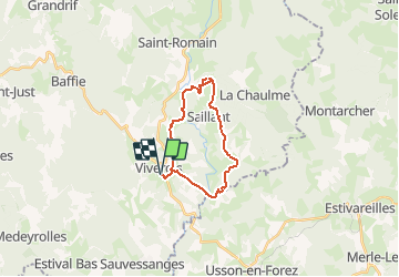
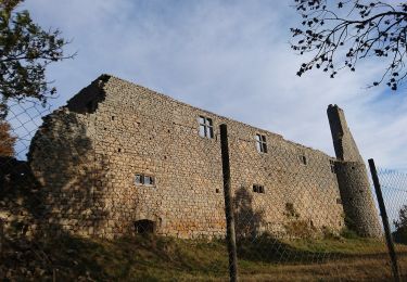
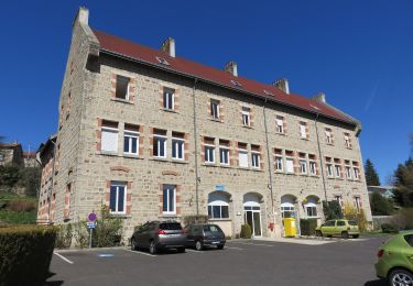
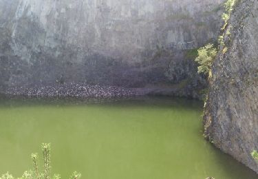
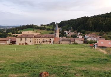
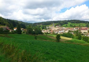
Randonnée V.T.T. de 19,8 km à découvrir à Auvergne-Rhône-Alpes, Puy-de-Dôme, Viverols. Cette randonnée est proposée par tracegps.
Description
Espace VTT FFC de la Vallée de l’Ance Circuit labellisé par la Fédération Française de Cyclisme. Ce circuit technique comporte de petits raidillons. Il vous fera découvrir les Orgues du Montpeloux avant un retour au calme par les bords ombragés de l’Ance.
Localisation
Pays :
France
Région :
Auvergne-Rhône-Alpes
Département/Province :
Puy-de-Dôme
Commune :
Viverols
Localité :
Unknown
Départ:(Dec)
Départ:(UTM)
569209 ; 5031247 (31T) N.
Commentaires
Randonnées à proximité
![Randonnée Marche Saillant - Le creux de l'Oulette - Les orgues basaltiques de Montpéroux - Photo](https://media.geolcdn.com/t/375/260/ext.jpg?maxdim=2&url=https%3A%2F%2Fservices.sitytrail.com%2FGeolivesWS%2FDownloadMedia.ashx%3FTrailID%3D107151%26Media%3D11994_2.jpg)
![Marche Marche](https://static1.geolcdn.com/sitytour/trail-icons/101.png)
Le creux de l'Oulette - Les orgues basaltiques de Montpéroux
Marche
Moyen
(4)
Saillant,
Auvergne-Rhône-Alpes,
Puy-de-Dôme,
France
![](/images/other/stat-length.png)
13,1 km | 18,3 km-effort
3h 15min
![](https://static1.geolcdn.com/siteimages/upload/files/16400158638029165_repeat_loop_refresh_sync_direction_icon.png)
Oui
![Randonnée A pied Saillant - Le Creux-de-l'Oulette - Photo](https://media.geolcdn.com/t/375/260/ext.jpg?maxdim=2&url=https%3A%2F%2Fmedia.geolcdn.com%2Ff%2F17f3ae01-a3f8-4b88-81a0-0838885dfc54.jpeg)
![A pied A pied](https://static1.geolcdn.com/sitytour/trail-icons/100.png)
Le Creux-de-l'Oulette
A pied
Facile
Saillant,
Auvergne-Rhône-Alpes,
Puy-de-Dôme,
France
![](/images/other/stat-length.png)
12 km | 17,1 km-effort
3h 53min
![](https://static1.geolcdn.com/siteimages/upload/files/16400158638029165_repeat_loop_refresh_sync_direction_icon.png)
Oui
![Randonnée A pied Sauvessanges - La Ligonne - Photo](https://media.geolcdn.com/t/375/260/ext.jpg?maxdim=2&url=https%3A%2F%2Fmedia.geolcdn.com%2Ff%2F5d52c9c1-1af3-422d-bc44-0604872e2c99.jpeg)
![A pied A pied](https://static1.geolcdn.com/sitytour/trail-icons/100.png)
La Ligonne
A pied
Facile
Sauvessanges,
Auvergne-Rhône-Alpes,
Puy-de-Dôme,
France
![](/images/other/stat-length.png)
9,4 km | 13,3 km-effort
3h 1min
![](https://static1.geolcdn.com/siteimages/upload/files/16400158638029165_repeat_loop_refresh_sync_direction_icon.png)
Oui
![Randonnée A pied Sauvessanges - Sauvessannelles - Photo](https://media.geolcdn.com/t/375/260/ext.jpg?maxdim=2&url=https%3A%2F%2Fmedia.geolcdn.com%2Ff%2F1902b60f-bf85-4fc3-ba7d-087c14f3c8f6.jpeg)
![A pied A pied](https://static1.geolcdn.com/sitytour/trail-icons/100.png)
Sauvessannelles
A pied
Facile
Sauvessanges,
Auvergne-Rhône-Alpes,
Puy-de-Dôme,
France
![](/images/other/stat-length.png)
9 km | 12,5 km-effort
2h 50min
![](https://static1.geolcdn.com/siteimages/upload/files/16400158638029165_repeat_loop_refresh_sync_direction_icon.png)
Oui
![Randonnée Marche Saillant - Saillant - Photo](https://media.geolcdn.com/t/375/260/ext.jpg?maxdim=2&url=https%3A%2F%2Fservices.sitytrail.com%2FGeolivesWS%2FDownloadMedia.ashx%3FTrailID%3D798472%26Media%3Dfix__20170729112006.jpg)
![Marche Marche](https://static1.geolcdn.com/sitytour/trail-icons/101.png)
Saillant
Marche
Très facile
(1)
Saillant,
Auvergne-Rhône-Alpes,
Puy-de-Dôme,
France
![](/images/other/stat-length.png)
13 km | 18,3 km-effort
3h 53min
![](https://static1.geolcdn.com/siteimages/upload/files/16400158638029165_repeat_loop_refresh_sync_direction_icon.png)
Oui
![Randonnée Marche Sauvessanges - PR de randonnée de Sauvessanges - Photo](https://media.geolcdn.com/t/375/260/ext.jpg?maxdim=2&url=https%3A%2F%2Fmedia.geolcdn.com%2Ff%2F2778395f-985f-4b3f-8b49-97543474da88.jpg)
![Marche Marche](https://static1.geolcdn.com/sitytour/trail-icons/101.png)
PR de randonnée de Sauvessanges
Marche
Très facile
Sauvessanges,
Auvergne-Rhône-Alpes,
Puy-de-Dôme,
France
![](/images/other/stat-length.png)
9,6 km | 13,5 km-effort
2h 34min
![](https://static1.geolcdn.com/siteimages/upload/files/16400158638029165_repeat_loop_refresh_sync_direction_icon.png)
Oui
![Randonnée V.T.T. Sauvessanges - Sauvessanges - Photo](https://media.geolcdn.com/t/375/260/ext.jpg?maxdim=2&url=https%3A%2F%2Fservices.sitytrail.com%2FGeolivesWS%2FDownloadMedia.ashx%3FTrailID%3D332559%26Media%3Dfix__20140809130619.jpg)
![V.T.T. V.T.T.](https://static1.geolcdn.com/sitytour/trail-icons/202.png)
Sauvessanges
V.T.T.
Moyen
Sauvessanges,
Auvergne-Rhône-Alpes,
Puy-de-Dôme,
France
![](/images/other/stat-length.png)
11,2 km | 15 km-effort
1h 4min
![](https://static1.geolcdn.com/siteimages/upload/files/16400158638029165_repeat_loop_refresh_sync_direction_icon.png)
Oui
![Randonnée Marche Églisolles - Marche du Siège de la Reine - Photo](https://media.geolcdn.com/t/375/260/ext.jpg?maxdim=2&url=https%3A%2F%2Fservices.sitytrail.com%2FGeolivesWS%2FDownloadMedia.ashx%3FTrailID%3D136155%26Media%3D20120628113129.jpg)
![Marche Marche](https://static1.geolcdn.com/sitytour/trail-icons/101.png)
Marche du Siège de la Reine
Marche
Moyen
Églisolles,
Auvergne-Rhône-Alpes,
Puy-de-Dôme,
France
![](/images/other/stat-length.png)
14,3 km | 20 km-effort
3h 34min
![](https://static1.geolcdn.com/siteimages/upload/files/16400158638029165_repeat_loop_refresh_sync_direction_icon.png)
Oui
![Randonnée Marche Sauvessanges - Sauvesannelles - Photo](https://media.geolcdn.com/t/375/260/ext.jpg?maxdim=2&url=https%3A%2F%2Fmedia.geolcdn.com%2Ff%2F303b8eaf-8063-46f7-91e6-5701c6c1fc35.jpg)
![Marche Marche](https://static1.geolcdn.com/sitytour/trail-icons/101.png)
Sauvesannelles
Marche
Moyen
Sauvessanges,
Auvergne-Rhône-Alpes,
Puy-de-Dôme,
France
![](/images/other/stat-length.png)
12,9 km | 17,1 km-effort
3h 50min
![](https://static1.geolcdn.com/siteimages/upload/files/16400158638029165_repeat_loop_refresh_sync_direction_icon.png)
Oui