


plain faing (Gazon du Faing 21 400m +998m)

DanielROLLET
Utilisateur
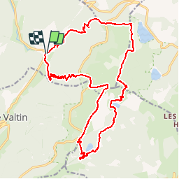

Longueur
20 km

Altitude max
1304 m

Dénivelé positif
978 m
Km-Effort
34 km

Altitude min
702 m

Dénivelé négatif
983 m
Boucle
Oui
Date de création :
2019-01-15 14:43:26.33
Dernière modification :
2019-01-15 14:43:26.33
7h05
Difficulté : Difficile

Application GPS de randonnée GRATUITE
 SityTrail
IGN / Instituts géographiques
SityTrail Plus
Le monde est à vous
À propos
Randonnée Marche de 20 km à découvrir à Grand Est, Vosges, Plainfaing. Cette randonnée est proposée par DanielROLLET.
Description
2018 08 15 10h00 à 17h00
Beaucoup de monde sur la crête et autour des lacs.
Localisation
Pays :
France
Région :
Grand Est
Département/Province :
Vosges
Commune :
Plainfaing
Localité :
Unknown
Départ:(Dec)
Départ:(UTM)
354370 ; 5331471 (32U) N.
Commentaires