![](/images/other/stat-length.png)
![Randonnée Marche Vignec - Au-dessus de Saint-Lary-Soulan - Photo](https://media.geolcdn.com/t/1900/400/ext.pjpeg?maxdim=2&url=https%3A%2F%2Fservices.sitytrail.com%2FGeolivesWS%2FDownloadMedia.ashx%3FTrailID%3D102865%26Media%3D4059_6.jpg)
Au-dessus de Saint-Lary-Soulan
tracegps
Utilisateur
![Longueur](/images/other/stat-length.png)
Longueur
11,8 km
![Altitude max](https://static1.geolcdn.com/siteimages/upload/files/1508320355ic_sort_altitude_max_24dp.png)
Altitude max
1419 m
![Dénivelé positif](https://static1.geolcdn.com/siteimages/upload/files/1508320355ic_sort_den_pos_24dp.png)
Dénivelé positif
646 m
![Km-Effort](/images/other/stat-length.png)
Km-Effort
20 km
![Altitude min](https://static1.geolcdn.com/siteimages/upload/files/1508320355ic_sort_altitude_min_24dp.png)
Altitude min
829 m
![Dénivelé négatif](https://static1.geolcdn.com/siteimages/upload/files/1508320355ic_sort_den_neg_24dp.png)
Dénivelé négatif
645 m
![Boucle](https://static1.geolcdn.com/siteimages/upload/files/16400158638029165_repeat_loop_refresh_sync_direction_icon.png)
Boucle
Oui
Date de création :
2014-12-10 00:00:00.0
Dernière modification :
2014-12-10 00:00:00.0
![Marche](https://static1.geolcdn.com/sitytour/trail-icons/101.png)
3h15
Difficulté : Moyen
![Scannez ce code QR pour ouvrir la randonnée dans l'application SityTrail](https://capi.geolives.com/qq0zvz2zws4bq2lad0pu/sitytour/trails/102865/qr.png?size=200)
Application GPS de randonnée GRATUITE
À propos
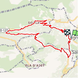
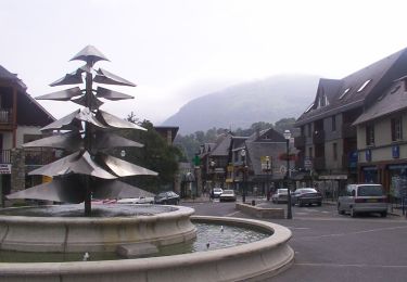
Randonnée Marche de 11,8 km à découvrir à Occitanie, Hautes-Pyrénées, Vignec. Cette randonnée est proposée par tracegps.
Description
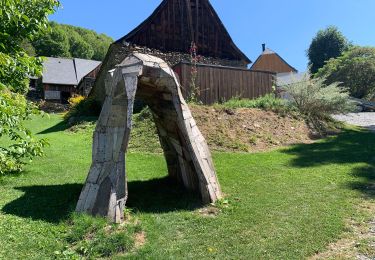
Boucle entre forêts et pâtures, de granges en villages, donnant un bon aperçu de l'architecture de la vallée d'Aure. Départ de l'église de Vignec.
Localisation
Pays :
France
Région :
Occitanie
Département/Province :
Hautes-Pyrénées
Commune :
Vignec
Localité :
Unknown
Départ:(Dec)
Départ:(UTM)
280547 ; 4744678 (31T) N.
Commentaires
Randonnées à proximité
![Randonnée Marche Saint-Lary-Soulan - 2011-08-03 15h51m06 - Photo](https://media.geolcdn.com/t/375/260/ext.jpg?maxdim=2&url=https%3A%2F%2Fservices.sitytrail.com%2FGeolivesWS%2FDownloadMedia.ashx%3FTrailID%3D70666%26Media%3D20110803154635.jpeg)
![Marche Marche](https://static1.geolcdn.com/sitytour/trail-icons/101.png)
2011-08-03 15h51m06
Marche
Très facile
(2)
Saint-Lary-Soulan,
Occitanie,
Hautes-Pyrénées,
France
![](/images/other/stat-length.png)
6,8 km | 9,8 km-effort
Inconnu
![](https://static1.geolcdn.com/siteimages/upload/files/16400158638029165_repeat_loop_refresh_sync_direction_icon.png)
Oui
![Randonnée Marche Ens - lacs de Consaterre - Photo](https://media.geolcdn.com/t/375/260/ext.jpg?maxdim=2&url=https%3A%2F%2Fstatic1.geolcdn.com%2Fsiteimages%2Fupload%2Ffiles%2F1553511878bg_sport_marche.png)
![Marche Marche](https://static1.geolcdn.com/sitytour/trail-icons/101.png)
lacs de Consaterre
Marche
Difficile
(1)
Ens,
Occitanie,
Hautes-Pyrénées,
France
![](/images/other/stat-length.png)
16,5 km | 34 km-effort
6h 56min
![](https://static1.geolcdn.com/siteimages/upload/files/16400158638029165_repeat_loop_refresh_sync_direction_icon.png)
Oui
![Randonnée Marche Azet - 2023-09-10 Azet-Col d'Azet crète de la Serre - Photo](https://media.geolcdn.com/t/375/260/ext.jpg?maxdim=2&url=https%3A%2F%2Fmedia.geolcdn.com%2Ff%2Fa241488d-7806-4d31-8df1-c552ae8f09f7.jpg)
![Marche Marche](https://static1.geolcdn.com/sitytour/trail-icons/101.png)
2023-09-10 Azet-Col d'Azet crète de la Serre
Marche
Très difficile
Azet,
Occitanie,
Hautes-Pyrénées,
France
![](/images/other/stat-length.png)
11,8 km | 19,4 km-effort
4h 24min
![](https://static1.geolcdn.com/siteimages/upload/files/16400158638029165_repeat_loop_refresh_sync_direction_icon.png)
Oui
![Randonnée sport Tramezaïgues - Au dessus de tramezaigues - Photo](https://media.geolcdn.com/t/375/260/ext.jpg?maxdim=2&url=https%3A%2F%2Fmedia.geolcdn.com%2Ff%2F6241ad0b-d07e-4c7e-b6a4-b04d00176721.jpg)
Au dessus de tramezaigues
sport
Très facile
Tramezaïgues,
Occitanie,
Hautes-Pyrénées,
France
![](/images/other/stat-length.png)
3 km | 5,8 km-effort
Inconnu
![](https://static1.geolcdn.com/siteimages/upload/files/16400158638029165_repeat_loop_refresh_sync_direction_icon.png)
Oui
![Randonnée A pied Saint-Lary-Soulan - Boucle de Caneilles - Photo](https://media.geolcdn.com/t/375/260/ext.jpg?maxdim=2&url=https%3A%2F%2Fmedia.geolcdn.com%2Ff%2F0b78c8a6-531b-4e32-888c-f6bec383597c.jpeg)
![A pied A pied](https://static1.geolcdn.com/sitytour/trail-icons/100.png)
Boucle de Caneilles
A pied
Facile
Saint-Lary-Soulan,
Occitanie,
Hautes-Pyrénées,
France
![](/images/other/stat-length.png)
4,2 km | 6,2 km-effort
1h 25min
![](https://static1.geolcdn.com/siteimages/upload/files/16400158638029165_repeat_loop_refresh_sync_direction_icon.png)
Non
![Randonnée Marche Bourisp - GR 10 - 27ème étape : Vielle Aure - Bourisp - Azet - Col d’Azet - Loudenvielle Germ - Photo](https://media.geolcdn.com/t/375/260/ext.jpg?maxdim=2&url=https%3A%2F%2Fmedia.geolcdn.com%2Ff%2F9fd82e7e-8a4b-45f0-b25e-68a07f11d343.jpg)
![Marche Marche](https://static1.geolcdn.com/sitytour/trail-icons/101.png)
GR 10 - 27ème étape : Vielle Aure - Bourisp - Azet - Col d’Azet - Loudenviell...
Marche
Moyen
Bourisp,
Occitanie,
Hautes-Pyrénées,
France
![](/images/other/stat-length.png)
12,7 km | 26 km-effort
3h 29min
![](https://static1.geolcdn.com/siteimages/upload/files/16400158638029165_repeat_loop_refresh_sync_direction_icon.png)
Non
![Randonnée Marche Bourisp - Camping Rioumajou - Agos - route de Soulan - Agos - Rioumajou à Bourisp - Photo](https://media.geolcdn.com/t/375/260/ext.jpg?maxdim=2&url=https%3A%2F%2Fmedia.geolcdn.com%2Ff%2Fa65ed445-6b9f-4e2f-a25e-f84f5d13f508.jpg)
![Marche Marche](https://static1.geolcdn.com/sitytour/trail-icons/101.png)
Camping Rioumajou - Agos - route de Soulan - Agos - Rioumajou à Bourisp
Marche
Difficile
Bourisp,
Occitanie,
Hautes-Pyrénées,
France
![](/images/other/stat-length.png)
6,4 km | 11,4 km-effort
2h 1min
![](https://static1.geolcdn.com/siteimages/upload/files/16400158638029165_repeat_loop_refresh_sync_direction_icon.png)
Oui
![Randonnée Marche Saint-Lary-Soulan - Soulan - les granges de Lias - Soulan - Photo](https://media.geolcdn.com/t/375/260/ext.jpg?maxdim=2&url=https%3A%2F%2Fmedia.geolcdn.com%2Ff%2F3bbe5244-bcfa-48ac-8df8-d0cf387d682b.jpg)
![Marche Marche](https://static1.geolcdn.com/sitytour/trail-icons/101.png)
Soulan - les granges de Lias - Soulan
Marche
Moyen
(1)
Saint-Lary-Soulan,
Occitanie,
Hautes-Pyrénées,
France
![](/images/other/stat-length.png)
7,1 km | 11,7 km-effort
2h 15min
![](https://static1.geolcdn.com/siteimages/upload/files/16400158638029165_repeat_loop_refresh_sync_direction_icon.png)
Oui
![Randonnée Marche Saint-Lary-Soulan - Balade de Caneilles - Photo](https://media.geolcdn.com/t/375/260/ext.jpg?maxdim=2&url=https%3A%2F%2Fstatic1.geolcdn.com%2Fsiteimages%2Fupload%2Ffiles%2F1553511878bg_sport_marche.png)
![Marche Marche](https://static1.geolcdn.com/sitytour/trail-icons/101.png)
Balade de Caneilles
Marche
Très facile
(1)
Saint-Lary-Soulan,
Occitanie,
Hautes-Pyrénées,
France
![](/images/other/stat-length.png)
6,8 km | 9,4 km-effort
2h 10min
![](https://static1.geolcdn.com/siteimages/upload/files/16400158638029165_repeat_loop_refresh_sync_direction_icon.png)
Oui
Difficile randonnée pédestre