Randonnée V.T.T. Monthermé - Monthermé - Naux - Photo
 tracegps
tracegps

Utilisateur

© OpenStreetMap contributors
Longueur
Longueur
32 km
Altitude max
Altitude max
401 m
Dénivelé positif
Dénivelé positif
694 m
Km-Effort
Km-Effort  
41 km
Altitude min
Altitude min
137 m
Dénivelé négatif
Dénivelé négatif
694 m
Boucle
Boucle
Oui
Date de création :
2014-12-10 00:00:00.0
Dernière modification :
2014-12-10 00:00:00.0

(0 Avis)

V.T.T.
V.T.T.
2h30
Difficulté : Difficile

Scannez ce code QR pour ouvrir la randonnée dans l'application SityTrail

Application GPS de randonnée GRATUITE

Logo SityTrail SityTrail

IGN / Instituts géographiques

Télécharger SityTrail sur l'App Store Télécharger SityTrail sur Google Play

Logo SityTrail SityTrail World

Le monde est à vous

Télécharger SityTrail sur l'App Store Télécharger SityTrail sur Google Play Télécharger SityTrail sur Huawei AppGallery

À propos

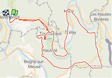
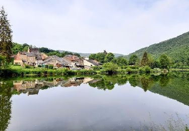
Randonnée V.T.T. de 32 km à découvrir à Grand Est, Ardennes, Monthermé. Cette randonnée est proposée par tracegps.

Description

Au départ de Monthermé, remonter la vallée de la Semoy jusqu'à Tournavaux. Monter vers la crête du Liry. (Site de parapente).Suivre toute la crête vers le col du Loup. Après le col traverser les bois des Grandes Hazelles direction la crête au dessus de Nohan.(Site de parapente). Redescendre ensuite à Naux et retour vers Monthermé par le fond de vallée en passant par Thilay, Haulmé et Tournavaux. Bonne balade. @da Choumac08

Profil altimétrique

Photos

Localisation

Pays :
France
Région :
Grand Est
Département/Province :
Ardennes
Commune :
Monthermé
Localité :
Unknown
Départ:(Dec)
Départ:(UTM)
625125 ; 5527000 (31U) N.

Randonnées à proximité

Randonnée Marche Haulmé - Thilay - Haulmé - Navaux - Photo
Marche
tracegps

Marche

Moyen
(3)
Haulmé, Grand Est, Ardennes, France
15,3 km | 21 km-effort
3h 15min
Oui
Randonnée Marche Monthermé - De Monthermé à Bogny sur Meuse par les sentiers de crêtes - Photo
Marche
tracegps

Marche

Difficile
(2)
Monthermé, Grand Est, Ardennes, France
14,6 km | 23 km-effort
5h 0min
Oui
Randonnée Marche Bogny-sur-Meuse - La promenade du Liry et des Quatre Fils Aymon - Photo
Marche
GUIDE
Desrumaux

Marche

Moyen
(1)
Bogny-sur-Meuse, Grand Est, Ardennes, France
11,4 km | 16,9 km-effort
3h 0min
Oui
Randonnée Marche Revin - Laifour-Montherme - Photo
Marche
Eric_Alu

Marche

Difficile
(1)
Revin, Grand Est, Ardennes, France
21 km | 30 km-effort
8h 8min
Non
Randonnée Marche Monthermé - La roche 7H Monthermé  - Photo
Marche
macrid

Marche

Moyen
Monthermé, Grand Est, Ardennes, France
5,9 km | 9 km-effort
2h 24min
Oui
Randonnée Marche Monthermé - les woiries  mercredi  - Photo
Marche
Nicolesophie08

Marche

Moyen
Monthermé, Grand Est, Ardennes, France
9,6 km | 12,7 km-effort
3h 37min
Non
Randonnée Marche Monthermé - Monthermé 22,7 km tour des rochers  - Photo
Marche
GUIDE
rvapeldo

Marche

Difficile
Monthermé, Grand Est, Ardennes, France
23 km | 36 km-effort
8h 20min
Oui
Randonnée Marche Monthermé - Monthermé - Photo
Marche
mjh

Marche

Moyen
Monthermé, Grand Est, Ardennes, France
16 km | 21 km-effort
3h 46min
Oui
Randonnée Marche Revin - de Layfour à Anchamps - Photo
Marche
jeannine grandjean

Marche

Très difficile
Revin, Grand Est, Ardennes, France
15,2 km | 20 km-effort
4h 1min
Non


Fermer
Mes abonnements