Randonnée Marche Creysse - Lot - Creysse Gluges Martel 18km 390m - Photo

Lot - Creysse Gluges Martel 18km 390m

 RandoVal
RandoVal

Utilisateur

© OpenStreetMap contributors
Longueur
Longueur
17,8 km
Altitude max
Altitude max
301 m
Dénivelé positif
Dénivelé positif
479 m
Km-Effort
Km-Effort  
24 km
Altitude min
Altitude min
106 m
Dénivelé négatif
Dénivelé négatif
479 m
Boucle
Boucle
Oui
Date de création :
2019-01-15 17:07:53.923
Dernière modification :
2019-01-15 17:07:53.923

(0 Avis)

Marche
Marche
5h08
Difficulté : Difficile

Scannez ce code QR pour ouvrir la randonnée dans l'application SityTrail

Application GPS de randonnée GRATUITE

Logo SityTrail SityTrail

IGN / Instituts géographiques

Télécharger SityTrail sur l'App Store Télécharger SityTrail sur Google Play

Logo SityTrail SityTrail World

Le monde est à vous

Télécharger SityTrail sur l'App Store Télécharger SityTrail sur Google Play Télécharger SityTrail sur Huawei AppGallery

À propos

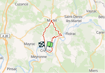
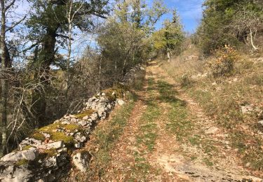
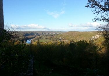
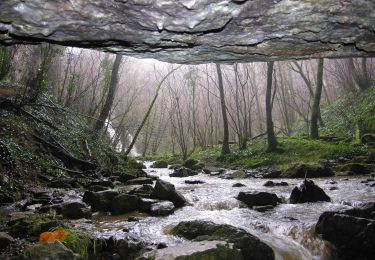
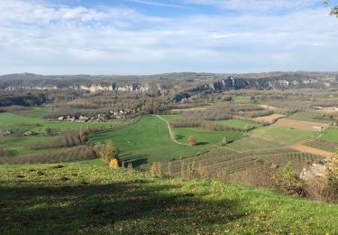
Randonnée Marche de 17,8 km à découvrir à Occitanie, Lot, Creysse. Cette randonnée est proposée par RandoVal.

Description

Boucle en Dordogne lotoise. Parking au pied de l'église, sens anti-horaire.

Profil altimétrique

Localisation

Pays :
France
Région :
Occitanie
Département/Province :
Lot
Commune :
Creysse
Localité :
Unknown
Départ:(Dec)
Départ:(UTM)
389109 ; 4971261 (31T) N.

Randonnées à proximité

Randonnée Marche Saint-Sozy - St-Sozy  - Photo
Marche
tracegps

Marche

Moyen
(5)
Saint-Sozy, Occitanie, Lot, France
8 km | 12 km-effort
2h 0min
Oui
Randonnée Marche Montvalent - Montvalent - Photo
Marche
Gpoujade

Marche

Moyen
(1)
Montvalent, Occitanie, Lot, France
13,7 km | 17,9 km-effort
3h 49min
Oui
Randonnée A pied Lacave - Gouffre et résurgence du Limon - Grottes de Lacave - Photo
A pied
PRO

A pied

Facile
Lacave, Occitanie, Lot, France
14,4 km | 19,6 km-effort
4h 26min
Oui
Randonnée Marche Saint-Sozy - Saint Sozy -  - Photo
Marche
houbart

Marche

Très difficile
Saint-Sozy, Occitanie, Lot, France
13,8 km | 20 km-effort
4h 15min
Oui
Randonnée Marche Montvalent - Bendou - Photo
Marche
Gaillard Isabelle

Marche

Facile
Montvalent, Occitanie, Lot, France
15,6 km | 21 km-effort
3h 38min
Oui
Randonnée Marche Montvalent - Causse toujours - Photo
Marche
sdroneau

Marche

Difficile
Montvalent, Occitanie, Lot, France
17,2 km | 23 km-effort
4h 30min
Oui
Randonnée V.T.T. Floirac - Boucle Floirac - Montvalent par Le Pech Cayrou et Roque De Cor - Photo
V.T.T.
Gpoujade

V.T.T.

Facile
Floirac, Occitanie, Lot, France
30 km | 38 km-effort
18min
Oui
Randonnée Marche Floirac - Floirac - Photo
Marche
Gaillard Isabelle

Marche

Facile
Floirac, Occitanie, Lot, France
15,1 km | 19,5 km-effort
3h 49min
Oui
Randonnée Marche Lacave - Pont de l'Ouysse Cougnaguet - Photo
Marche
neleda

Marche

Très facile
Lacave, Occitanie, Lot, France
13,9 km | 16,5 km-effort
3h 32min
Oui


Fermer
Mes abonnements