Randonnée Vélo Ervy-le-Châtel - Pays d'Armance : à la découverte d'un village perché  - Ervy le Châtel - Photo

Pays d'Armance : à la découverte d'un village perché - Ervy le Châtel

 tracegps
tracegps

Utilisateur

© OpenStreetMap contributors
Longueur
Longueur
75 km
Altitude max
Altitude max
291 m
Dénivelé positif
Dénivelé positif
837 m
Km-Effort
Km-Effort  
86 km
Altitude min
Altitude min
108 m
Dénivelé négatif
Dénivelé négatif
840 m
Boucle
Boucle
Oui
Date de création :
2014-12-10 00:00:00.0
Dernière modification :
2014-12-10 00:00:00.0

(0 Avis)

Vélo
Vélo
4h00
Difficulté : Difficile

Scannez ce code QR pour ouvrir la randonnée dans l'application SityTrail

Application GPS de randonnée GRATUITE

Logo SityTrail SityTrail

IGN / Instituts géographiques

Télécharger SityTrail sur l'App Store Télécharger SityTrail sur Google Play

Logo SityTrail SityTrail World

Le monde est à vous

Télécharger SityTrail sur l'App Store Télécharger SityTrail sur Google Play Télécharger SityTrail sur Huawei AppGallery

À propos

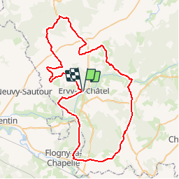
Randonnée Vélo de 75 km à découvrir à Grand Est, Aube, Ervy-le-Châtel. Cette randonnée est proposée par tracegps.

Description

Proposé par le Comité Départemental du Tourisme de l'Aube, un circuit créé et validé par la Fédération Départementale du Cyclotourisme de l’Aube. Pays d’Armance : à la découverte d’un village perché – 75 km - Ervy-le-Châtel et sa halle circulaire - Eglise de Racines - Eaux-Puiseaux : musée du cidre - Auxon : Eglise Saint-Loup (XVIème siècle).

Profil altimétrique

Photos

Points d'intérêt

Point d'intérêt Ervy-le-Châtel - cycloguide N?06 Pays d?Armance : ? la d?couverte d 74.839 km - Photo
tracegps

Localisation

Pays :
France
Région :
Grand Est
Département/Province :
Aube
Commune :
Ervy-le-Châtel
Localité :
Unknown
Départ:(Dec)
Départ:(UTM)
567969 ; 5321206 (31U) N.

Randonnées à proximité

Randonnée Marche Ervy-le-Châtel - ERVY LE CHATEL, au départ de la halle - Photo
Marche
jeannine grandjean

Marche

Moyen
(1)
Ervy-le-Châtel, Grand Est, Aube, France
10,1 km | 11,4 km-effort
2h 35min
Oui
Randonnée Marche Davrey - Circuit de Davrey - Photo
Marche
tracegps

Marche

Très difficile
Davrey, Grand Est, Aube, France
16,4 km | 17,8 km-effort
4h 10min
Oui
Randonnée Marche Ervy-le-Châtel - Circuit des Chaumes Blanches - Ervy-le-Chatel - Photo
Marche
tracegps

Marche

Facile
Ervy-le-Châtel, Grand Est, Aube, France
6,3 km | 7,3 km-effort
1h 34min
Oui
Randonnée Marche Ervy-le-Châtel - Circuit du bois du Parc - Ervy-le-Chatel - Photo
Marche
tracegps

Marche

Moyen
Ervy-le-Châtel, Grand Est, Aube, France
10,1 km | 11,5 km-effort
2h 30min
Oui
Randonnée Marche Ervy-le-Châtel - Circuit de l'Armance - Ervy-le-Chatel - Photo
Marche
tracegps

Marche

Facile
Ervy-le-Châtel, Grand Est, Aube, France
4,8 km | 5,7 km-effort
1h 15min
Oui
Randonnée Marche Davrey - davrey - Photo
Marche
bougnaou

Marche

Moyen
Davrey, Grand Est, Aube, France
17,3 km | 18,8 km-effort
6h 0min
Oui
Randonnée Marche Davrey - Davrey balisage 22 juillet 24 - Photo
Marche
bougnaou

Marche

Moyen
Davrey, Grand Est, Aube, France
17,1 km | 18,5 km-effort
7h 13min
Oui
Randonnée Marche Davrey - Davrey (10) - Circuit de Davrey - Photo
Marche
temmichel

Marche

Difficile
Davrey, Grand Est, Aube, France
15,9 km | 17,2 km-effort
3h 55min
Oui
Randonnée Marche Ervy-le-Châtel - ervy nocturne 23 - Photo
Marche
bougnaou

Marche

Facile
Ervy-le-Châtel, Grand Est, Aube, France
11,5 km | 12,9 km-effort
2h 45min
Oui


Fermer
Mes abonnements