


hatton fosse fournier hatton

ochelen
Utilisateur
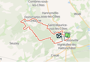

Longueur
30 km

Altitude max
415 m

Dénivelé positif
574 m
Km-Effort
37 km

Altitude min
247 m

Dénivelé négatif
567 m
Boucle
Non
Date de création :
2019-05-06 23:22:21.674
Dernière modification :
2019-05-06 23:22:21.674
1h35
Difficulté : Inconnu

Application GPS de randonnée GRATUITE
 SityTrail
IGN / Instituts géographiques
SityTrail Plus
Le monde est à vous
À propos
Randonnée Cheval de 30 km à découvrir à Grand Est, Meuse, Vigneulles-lès-Hattonchâtel. Cette randonnée est proposée par ochelen.
Localisation
Pays :
France
Région :
Grand Est
Département/Province :
Meuse
Commune :
Vigneulles-lès-Hattonchâtel
Localité :
Hattonchâtel
Départ:(Dec)
Départ:(UTM)
697181 ; 5429942 (31U) N.
Commentaires