


baisy thy

ochelen
Utilisateur
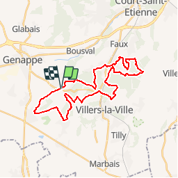

Longueur
29 km

Altitude max
164 m

Dénivelé positif
526 m
Km-Effort
36 km

Altitude min
78 m

Dénivelé négatif
527 m
Boucle
Oui
Date de création :
2019-05-06 23:54:24.69
Dernière modification :
2019-05-06 23:54:24.69
4h31
Difficulté : Inconnu

Application GPS de randonnée GRATUITE
 SityTrail
IGN / Instituts géographiques
SityTrail Plus
Le monde est à vous
À propos
Randonnée Cheval de 29 km à découvrir à Wallonie, Brabant wallon, Genappe. Cette randonnée est proposée par ochelen.
Localisation
Pays :
Belgique
Région :
Wallonie
Département/Province :
Brabant wallon
Commune :
Genappe
Localité :
Baisy-Thy
Départ:(Dec)
Départ:(UTM)
605469 ; 5605566 (31U) N.
Commentaires