Randonnée V.T.T. Trespoux-Rassiels - Zevtt - Trespoux VTT - Photo
 kipoura
kipoura

Utilisateur

© OpenStreetMap contributors
Longueur
Longueur
58 km
Altitude max
Altitude max
343 m
Dénivelé positif
Dénivelé positif
1483 m
Km-Effort
Km-Effort  
78 km
Altitude min
Altitude min
103 m
Dénivelé négatif
Dénivelé négatif
1491 m
Boucle
Boucle
Oui
Date de création :
2019-05-03 17:11:13.832
Dernière modification :
2019-05-03 17:11:13.881

(0 Avis)

V.T.T.
V.T.T.
3h00
Difficulté : Moyen

Scannez ce code QR pour ouvrir la randonnée dans l'application SityTrail

Application GPS de randonnée GRATUITE

Logo SityTrail SityTrail

IGN / Instituts géographiques

Télécharger SityTrail sur l'App Store Télécharger SityTrail sur Google Play

Logo SityTrail SityTrail World

Le monde est à vous

Télécharger SityTrail sur l'App Store Télécharger SityTrail sur Google Play Télécharger SityTrail sur Huawei AppGallery

À propos

Randonnée V.T.T. de 58 km à découvrir à Occitanie, Lot, Trespoux-Rassiels. Cette randonnée est proposée par kipoura.

Description

Une boucle des plus ludique en VTT, vive le Lot .... http://zevtt.free.fr

Profil altimétrique

Localisation

Pays :
France
Région :
Occitanie
Département/Province :
Lot
Commune :
Trespoux-Rassiels
Localité :
Unknown
Départ:(Dec)
Départ:(UTM)
370326 ; 4919201 (31T) N.

Randonnées à proximité

Randonnée V.T.T. Cahors - Cahors-La Rozière 2005 - Photo
V.T.T.
tracegps

V.T.T.

Très difficile
(1)
Cahors, Occitanie, Lot, France
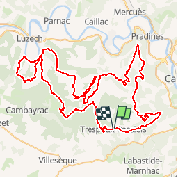
62 km | 81 km-effort
5h 0min
Oui
Randonnée Marche Pradines - Cahors les Durands 7km - Photo
Marche
PariseJL

Marche

Facile
(1)
Pradines, Occitanie, Lot, France
7,1 km | 9,3 km-effort
2h 13min
Oui
Randonnée Marche Cahors - Croix magne  - Photo
Marche
GUIDE
antignacs

Marche

Très facile
Cahors, Occitanie, Lot, France
5,2 km | 7,2 km-effort
1h 20min
Non
Randonnée Marche Labastide-Marnhac - Mon Compostelle huitième étape - Photo
Marche
Ardeiserois

Marche

Difficile
Labastide-Marnhac, Occitanie, Lot, France
51 km | 65 km-effort
10h 40min
Non
Randonnée V.T.T. Trespoux-Rassiels - Circuit ouest de Trespoux Rassiels - Photo
V.T.T.
tracegps

V.T.T.

Très difficile
Trespoux-Rassiels, Occitanie, Lot, France
38 km | 51 km-effort
4h 15min
Oui
Randonnée Course à pied Cahors - Cahors, le Lot, le causse, la vieille ville - Photo
Course à pied
tracegps

Course à pied

Moyen
Cahors, Occitanie, Lot, France
7,3 km | 10 km-effort
45min
Oui
Randonnée Marche Cahors - Cahors, le Lot, le causse, la vieille ville - Photo
Marche
tracegps

Marche

Moyen
Cahors, Occitanie, Lot, France
7,3 km | 10 km-effort
1h 30min
Oui
Randonnée V.T.T. Cahors - Raid Cahors La Rozière 2006 - Photo
V.T.T.
tracegps

V.T.T.

Très difficile
Cahors, Occitanie, Lot, France
59 km | 78 km-effort
4h 40min
Oui
Randonnée Marche Trespoux-Rassiels - filles de manu 1juin24 - Photo
Marche
pedromartin

Marche

Moyen
Trespoux-Rassiels, Occitanie, Lot, France
5 km | 7,2 km-effort
1h 33min
Oui


Fermer
Mes abonnements