![](/images/other/stat-length.png)
![Randonnée V.T.T. Ganac - Prat d'Albis - Vernajoul - Photo](https://media.geolcdn.com/t/1900/400/ext.pjpeg?maxdim=2&url=https%3A%2F%2Fstatic1.geolcdn.com%2Fsiteimages%2Fupload%2Ffiles%2F1524743154velo.jpg)
Prat d'Albis - Vernajoul
daliot
Utilisateur
![Longueur](/images/other/stat-length.png)
Longueur
24 km
![Altitude max](https://static1.geolcdn.com/siteimages/upload/files/1508320355ic_sort_altitude_max_24dp.png)
Altitude max
1392 m
![Dénivelé positif](https://static1.geolcdn.com/siteimages/upload/files/1508320355ic_sort_den_pos_24dp.png)
Dénivelé positif
459 m
![Km-Effort](/images/other/stat-length.png)
Km-Effort
34 km
![Altitude min](https://static1.geolcdn.com/siteimages/upload/files/1508320355ic_sort_altitude_min_24dp.png)
Altitude min
404 m
![Dénivelé négatif](https://static1.geolcdn.com/siteimages/upload/files/1508320355ic_sort_den_neg_24dp.png)
Dénivelé négatif
1444 m
![Boucle](https://static1.geolcdn.com/siteimages/upload/files/16400158638029165_repeat_loop_refresh_sync_direction_icon.png)
Boucle
Non
Date de création :
2014-12-10 00:00:00.0
Dernière modification :
2014-12-10 00:00:00.0
![V.T.T.](https://static1.geolcdn.com/sitytour/trail-icons/202.png)
3h56
Difficulté : Très difficile
![Scannez ce code QR pour ouvrir la randonnée dans l'application SityTrail](https://capi.geolives.com/qq0zvz2zws4bq2lad0pu/sitytour/trails/125031/qr.png?size=200)
Application GPS de randonnée GRATUITE
À propos
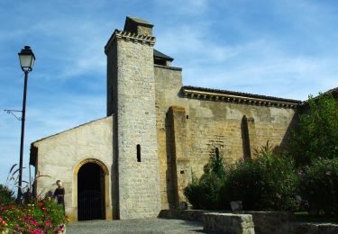
Randonnée V.T.T. de 24 km à découvrir à Occitanie, Ariège, Ganac. Cette randonnée est proposée par daliot.
Description
Descente assez technique par endroit, attention aux pierres notamment en arrivant sur Vernajoul. Sentier peu balisé à certain endroit. Avant d'arriver à la ferme Lizonne bien regarder le sentier qui tourne à gauche. Un petit panneau vert indique Vernajoul
Localisation
Pays :
France
Région :
Occitanie
Département/Province :
Ariège
Commune :
Ganac
Localité :
Unknown
Départ:(Dec)
Départ:(UTM)
382915 ; 4752046 (31T) N.
Commentaires
Randonnées à proximité
![Randonnée V.T.T. Ganac - Prat Albis - Verniolle - Photo](https://media.geolcdn.com/t/375/260/ext.jpg?maxdim=2&url=https%3A%2F%2Fservices.sitytrail.com%2FGeolivesWS%2FDownloadMedia.ashx%3FTrailID%3D128789%26Media%3D05b2f854-454a-4b38-ac8f-0c42da59f54b.jpg)
![V.T.T. V.T.T.](https://static1.geolcdn.com/sitytour/trail-icons/202.png)
Prat Albis - Verniolle
V.T.T.
Difficile
(1)
Ganac,
Occitanie,
Ariège,
France
![](/images/other/stat-length.png)
30 km | 36 km-effort
2h 30min
![](https://static1.geolcdn.com/siteimages/upload/files/16400158638029165_repeat_loop_refresh_sync_direction_icon.png)
Non
![Randonnée Marche Prayols - Cuminge - Photo](https://media.geolcdn.com/t/375/260/ext.jpg?maxdim=2&url=https%3A%2F%2Fstatic1.geolcdn.com%2Fsiteimages%2Fupload%2Ffiles%2F1553511878bg_sport_marche.png)
![Marche Marche](https://static1.geolcdn.com/sitytour/trail-icons/101.png)
![Randonnée Marche Ganac - Prat d'Albis - Photo](https://media.geolcdn.com/t/375/260/ext.jpg?maxdim=2&url=https%3A%2F%2Fmedia.geolcdn.com%2Ff%2F94538044-696f-49c3-99b2-381f51b7e113.jpg)
![Marche Marche](https://static1.geolcdn.com/sitytour/trail-icons/101.png)
Prat d'Albis
Marche
Très facile
Ganac,
Occitanie,
Ariège,
France
![](/images/other/stat-length.png)
8,6 km | 12,6 km-effort
3h 2min
![](https://static1.geolcdn.com/siteimages/upload/files/16400158638029165_repeat_loop_refresh_sync_direction_icon.png)
Non
![Randonnée A pied Brassac - Le Picou depuis Brassac - Photo](https://media.geolcdn.com/t/375/260/ext.jpg?maxdim=2&url=https%3A%2F%2Fmedia.geolcdn.com%2Ff%2F22e65925-2aed-45df-a24b-d9dbd1aee596.jpeg)
![A pied A pied](https://static1.geolcdn.com/sitytour/trail-icons/100.png)
Le Picou depuis Brassac
A pied
Facile
Brassac,
Occitanie,
Ariège,
France
![](/images/other/stat-length.png)
5 km | 14,7 km-effort
3h 20min
![](https://static1.geolcdn.com/siteimages/upload/files/16400158638029165_repeat_loop_refresh_sync_direction_icon.png)
Non
![Randonnée A pied Montoulieu - La cabane des gardes - Photo](https://media.geolcdn.com/t/375/260/ext.jpg?maxdim=2&url=https%3A%2F%2Fmedia.geolcdn.com%2Ff%2Fb1e64f52-ac0f-467f-8d74-d3b4ab718910.jpg)
![A pied A pied](https://static1.geolcdn.com/sitytour/trail-icons/100.png)
La cabane des gardes
A pied
Moyen
Montoulieu,
Occitanie,
Ariège,
France
![](/images/other/stat-length.png)
15,5 km | 25 km-effort
Inconnu
![](https://static1.geolcdn.com/siteimages/upload/files/16400158638029165_repeat_loop_refresh_sync_direction_icon.png)
Oui
![Randonnée V.T.T. Ganac - prat - prayols 1 - Photo](https://media.geolcdn.com/t/375/260/ext.jpg?maxdim=2&url=https%3A%2F%2Fstatic1.geolcdn.com%2Fsiteimages%2Fupload%2Ffiles%2F1524743154velo.jpg)
![V.T.T. V.T.T.](https://static1.geolcdn.com/sitytour/trail-icons/202.png)
prat - prayols 1
V.T.T.
Moyen
(1)
Ganac,
Occitanie,
Ariège,
France
![](/images/other/stat-length.png)
7,7 km | 11,1 km-effort
41min
![](https://static1.geolcdn.com/siteimages/upload/files/16400158638029165_repeat_loop_refresh_sync_direction_icon.png)
Non
![Randonnée Marche Bédeilhac-et-Aynat - au pied du Calames - Photo](https://media.geolcdn.com/t/375/260/ext.jpg?maxdim=2&url=https%3A%2F%2Fmedia.geolcdn.com%2Ff%2F868d4fd2-2cb9-498b-a9b3-14af85ea0b3c.jpg)
![Marche Marche](https://static1.geolcdn.com/sitytour/trail-icons/101.png)
au pied du Calames
Marche
Facile
Bédeilhac-et-Aynat,
Occitanie,
Ariège,
France
![](/images/other/stat-length.png)
14,1 km | 23 km-effort
4h 55min
![](https://static1.geolcdn.com/siteimages/upload/files/16400158638029165_repeat_loop_refresh_sync_direction_icon.png)
Oui
![Randonnée Marche Ganac - cabane des Bladas - Photo](https://media.geolcdn.com/t/375/260/ext.jpg?maxdim=2&url=https%3A%2F%2Fmedia.geolcdn.com%2Ff%2F8bd150a0-3aab-453f-8910-10bb01e9a7c9.jpg)
![Marche Marche](https://static1.geolcdn.com/sitytour/trail-icons/101.png)
![Randonnée Marche Prayols - picou - Photo](https://media.geolcdn.com/t/375/260/ext.jpg?maxdim=2&url=https%3A%2F%2Fmedia.geolcdn.com%2Ff%2Fd03a81ba-1538-441a-8827-4fe23687f060.jpg)
![Marche Marche](https://static1.geolcdn.com/sitytour/trail-icons/101.png)