Randonnée Moteur Kaysersberg-Vignoble - Ursprung - St Alexis - Photo
 daze
daze

Utilisateur

© OpenStreetMap contributors
Longueur
Longueur
12,5 km
Altitude max
Altitude max
749 m
Dénivelé positif
Dénivelé positif
431 m
Km-Effort
Km-Effort  
18,4 km
Altitude min
Altitude min
281 m
Dénivelé négatif
Dénivelé négatif
461 m
Boucle
Boucle
Non
Date de création :
2014-12-10 00:00:00.0
Dernière modification :
2014-12-10 00:00:00.0

(0 Avis)

Moteur
Moteur
--
Difficulté : Facile

Scannez ce code QR pour ouvrir la randonnée dans l'application SityTrail

Application GPS de randonnée GRATUITE

Logo SityTrail SityTrail

IGN / Instituts géographiques

Télécharger SityTrail sur l'App Store Télécharger SityTrail sur Google Play

Logo SityTrail SityTrail World

Le monde est à vous

Télécharger SityTrail sur l'App Store Télécharger SityTrail sur Google Play Télécharger SityTrail sur Huawei AppGallery

À propos

Randonnée Moteur de 12,5 km à découvrir à Grand Est, Haut-Rhin, Kaysersberg-Vignoble. Cette randonnée est proposée par daze.

Description

Ursprung - St Alexis

Profil altimétrique

Localisation

Pays :
France
Région :
Grand Est
Département/Province :
Haut-Rhin
Commune :
Kaysersberg-Vignoble
Localité :
Kaysersberg
Départ:(Dec)
Départ:(UTM)
368685 ; 5335011 (32U) N.

Randonnées à proximité

Randonnée Marche Ammerschwihr - D'Ammerschwihr aux Trois Epis - Photo
Marche
VacheKiri67

Marche

Difficile
(1)
Ammerschwihr, Grand Est, Haut-Rhin, France
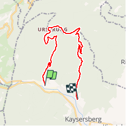
17,1 km | 25 km-effort
5h 35min
Oui
Randonnée Marche Kaysersberg-Vignoble - 2021-05-30 Marche Kaysersberg Ursprung St Alexis - Photo
Marche
GUIDE
holtzv

Marche

Très difficile
Kaysersberg-Vignoble, Grand Est, Haut-Rhin, France
17,1 km | 26 km-effort
4h 46min
Oui
Randonnée Randonnée équestre Kaysersberg-Vignoble - 2019-10-26 CDTE67 Tournage Video Promotion TE - Photo
Randonnée équestre
GUIDE
holtzv

Randonnée équestre

Facile
Kaysersberg-Vignoble, Grand Est, Haut-Rhin, France
24 km | 29 km-effort
24min
Non
Randonnée Marche Kaysersberg-Vignoble - Le tour de Kysersberg - Photo
Marche
GUIDE
pascalou73

Marche

Moyen
(1)
Kaysersberg-Vignoble, Grand Est, Haut-Rhin, France
7,9 km | 11,7 km-effort
2h 34min
Oui
Randonnée Marche Fréland - CVL - Rando 25/03/2024 - Col de Chamont - Photo
Marche
Hub6877

Marche

Moyen
Fréland, Grand Est, Haut-Rhin, France
6,6 km | 9,5 km-effort
2h 15min
Oui
Randonnée Marche Kaysersberg-Vignoble - Rando CLAS du 29/02/2025 - Photo
Marche
boubou68

Marche

Très difficile
Kaysersberg-Vignoble, Grand Est, Haut-Rhin, France
19,6 km | 29 km-effort
4h 37min
Oui
Randonnée Marche Kaysersberg-Vignoble - Kaysersberg Kientzheim  - Photo
Marche
FOUCAULT

Marche

Kaysersberg-Vignoble, Grand Est, Haut-Rhin, France
8,9 km | 9,8 km-effort
2h 47min
Oui
Randonnée Marche Riquewihr - Riquewihr  - Photo
Marche
ISATR

Marche

Moyen
Riquewihr, Grand Est, Haut-Rhin, France
13,8 km | 18,2 km-effort
4h 8min
Oui
Randonnée Marche Aubure - Aubure rocher du tétras  - Photo
Marche
apa

Marche

Moyen
Aubure, Grand Est, Haut-Rhin, France
10,9 km | 14,6 km-effort
3h 54min
Oui


Fermer
Mes abonnements