![](/images/other/stat-length.png)
![Randonnée V.T.T. Saint-Vallier-de-Thiey - Au sud de St Vallier - Photo](https://media.geolcdn.com/t/1900/400/ext.pjpeg?maxdim=2&url=https%3A%2F%2Fstatic1.geolcdn.com%2Fsiteimages%2Fupload%2Ffiles%2F1524743154velo.jpg)
Au sud de St Vallier
Reich
Utilisateur
![Longueur](/images/other/stat-length.png)
Longueur
27 km
![Altitude max](https://static1.geolcdn.com/siteimages/upload/files/1508320355ic_sort_altitude_max_24dp.png)
Altitude max
781 m
![Dénivelé positif](https://static1.geolcdn.com/siteimages/upload/files/1508320355ic_sort_den_pos_24dp.png)
Dénivelé positif
657 m
![Km-Effort](/images/other/stat-length.png)
Km-Effort
36 km
![Altitude min](https://static1.geolcdn.com/siteimages/upload/files/1508320355ic_sort_altitude_min_24dp.png)
Altitude min
483 m
![Dénivelé négatif](https://static1.geolcdn.com/siteimages/upload/files/1508320355ic_sort_den_neg_24dp.png)
Dénivelé négatif
657 m
![Boucle](https://static1.geolcdn.com/siteimages/upload/files/16400158638029165_repeat_loop_refresh_sync_direction_icon.png)
Boucle
Oui
Date de création :
2018-10-06 07:22:48.399
Dernière modification :
2018-10-07 06:46:50.194
![V.T.T.](https://static1.geolcdn.com/sitytour/trail-icons/202.png)
2h40
Difficulté : Moyen
![Scannez ce code QR pour ouvrir la randonnée dans l'application SityTrail](https://capi.geolives.com/qq0zvz2zws4bq2lad0pu/sitytour/trails/2012479/qr.png?size=200)
Application GPS de randonnée GRATUITE
À propos
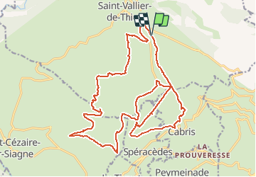
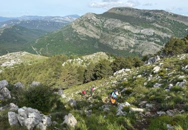
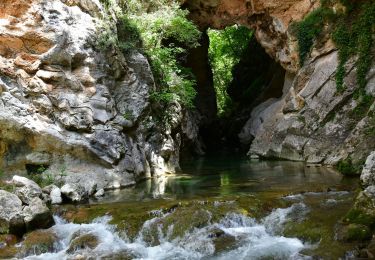
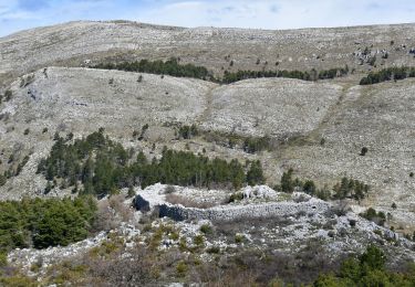
Randonnée V.T.T. de 27 km à découvrir à Provence-Alpes-Côte d'Azur, Alpes-Maritimes, Saint-Vallier-de-Thiey. Cette randonnée est proposée par Reich.
Description
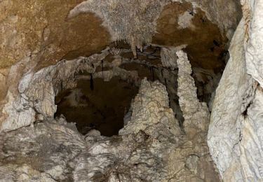
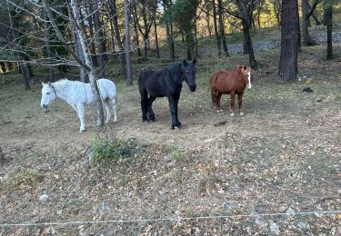
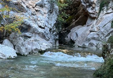
St-Vallier-Cabris-Bois d'Amon et retour. Rando roulante mis à part une partie un peu cassante dans la descente du gazoduc (éboulis, la zone mériterait d'être un peu nettoyée).
Localisation
Pays :
France
Région :
Provence-Alpes-Côte d'Azur
Département/Province :
Alpes-Maritimes
Commune :
Saint-Vallier-de-Thiey
Localité :
Unknown
Départ:(Dec)
Départ:(UTM)
327598 ; 4839675 (32T) N.
Commentaires
Randonnées à proximité
![Randonnée Marche Grasse - petit rando au dessus de Grasse - Photo](https://media.geolcdn.com/t/375/260/ext.jpg?maxdim=2&url=https%3A%2F%2Fservices.sitytrail.com%2FGeolivesWS%2FDownloadMedia.ashx%3FTrailID%3D219692%26Media%3Dfix__20130907100916.jpg)
![Marche Marche](https://static1.geolcdn.com/sitytour/trail-icons/101.png)
petit rando au dessus de Grasse
Marche
Moyen
(1)
Grasse,
Provence-Alpes-Côte d'Azur,
Alpes-Maritimes,
France
![](/images/other/stat-length.png)
6 km | 10,6 km-effort
1h 55min
![](https://static1.geolcdn.com/siteimages/upload/files/16400158638029165_repeat_loop_refresh_sync_direction_icon.png)
Oui
![Randonnée A pied Grasse - Tour de la Marbrière - Photo](https://media.geolcdn.com/t/375/260/ext.jpg?maxdim=2&url=https%3A%2F%2Fmedia.geolcdn.com%2Ff%2F75605552-a463-425d-8862-67e7b2a12a52.jpeg)
![A pied A pied](https://static1.geolcdn.com/sitytour/trail-icons/100.png)
Tour de la Marbrière
A pied
Facile
Grasse,
Provence-Alpes-Côte d'Azur,
Alpes-Maritimes,
France
![](/images/other/stat-length.png)
5,5 km | 10 km-effort
2h 16min
![](https://static1.geolcdn.com/siteimages/upload/files/16400158638029165_repeat_loop_refresh_sync_direction_icon.png)
Oui
![Randonnée Marche Saint-Cézaire-sur-Siagne - Col de Cabris - Photo](https://media.geolcdn.com/t/375/260/ext.jpg?maxdim=2&url=https%3A%2F%2Fstatic1.geolcdn.com%2Fsiteimages%2Fupload%2Ffiles%2F1553511878bg_sport_marche.png)
![Marche Marche](https://static1.geolcdn.com/sitytour/trail-icons/101.png)
Col de Cabris
Marche
Facile
(1)
Saint-Cézaire-sur-Siagne,
Provence-Alpes-Côte d'Azur,
Alpes-Maritimes,
France
![](/images/other/stat-length.png)
7,3 km | 9,7 km-effort
3h 0min
![](https://static1.geolcdn.com/siteimages/upload/files/16400158638029165_repeat_loop_refresh_sync_direction_icon.png)
Oui
![Randonnée Marche Saint-Vallier-de-Thiey - St Vallier : Colle du maçon doublier - Photo](https://media.geolcdn.com/t/375/260/ext.jpg?maxdim=2&url=https%3A%2F%2Fmedia.geolcdn.com%2Ff%2F4e394125-44db-4de9-b615-b5e106949b4d.jpg)
![Marche Marche](https://static1.geolcdn.com/sitytour/trail-icons/101.png)
St Vallier : Colle du maçon doublier
Marche
Difficile
Saint-Vallier-de-Thiey,
Provence-Alpes-Côte d'Azur,
Alpes-Maritimes,
France
![](/images/other/stat-length.png)
18,2 km | 29 km-effort
6h 35min
![](https://static1.geolcdn.com/siteimages/upload/files/16400158638029165_repeat_loop_refresh_sync_direction_icon.png)
Oui
![Randonnée Marche Saint-Vallier-de-Thiey - St Vallier de Thiey - Col de la Lèque - Chapelle St Jean - Arche Ponadieu - Photo](https://media.geolcdn.com/t/375/260/ext.jpg?maxdim=2&url=https%3A%2F%2Fmedia.geolcdn.com%2Ff%2F05918623-5269-4fde-a6db-7248b99e79ca.JPG)
![Marche Marche](https://static1.geolcdn.com/sitytour/trail-icons/101.png)
St Vallier de Thiey - Col de la Lèque - Chapelle St Jean - Arche Ponadieu
Marche
Moyen
Saint-Vallier-de-Thiey,
Provence-Alpes-Côte d'Azur,
Alpes-Maritimes,
France
![](/images/other/stat-length.png)
14,1 km | 21 km-effort
4h 44min
![](https://static1.geolcdn.com/siteimages/upload/files/16400158638029165_repeat_loop_refresh_sync_direction_icon.png)
Oui
![Randonnée Marche Saint-Vallier-de-Thiey - St Vallier : Pare2 - Photo](https://media.geolcdn.com/t/375/260/ext.jpg?maxdim=2&url=https%3A%2F%2Fmedia.geolcdn.com%2Ff%2F0e23e1f7-5365-422d-9e17-aca855b1fa8e.jpeg)
![Marche Marche](https://static1.geolcdn.com/sitytour/trail-icons/101.png)
St Vallier : Pare2
Marche
Difficile
Saint-Vallier-de-Thiey,
Provence-Alpes-Côte d'Azur,
Alpes-Maritimes,
France
![](/images/other/stat-length.png)
17,7 km | 29 km-effort
6h 35min
![](https://static1.geolcdn.com/siteimages/upload/files/16400158638029165_repeat_loop_refresh_sync_direction_icon.png)
Oui
![Randonnée Marche Saint-Vallier-de-Thiey - St Vallier de Thiey - Col du Ferrier - Castellaras de la Malle - Col du Pilon - Pierre Druidique - Photo](https://media.geolcdn.com/t/375/260/ext.jpg?maxdim=2&url=https%3A%2F%2Fmedia.geolcdn.com%2Ff%2F0ca7f168-1d3d-4587-8f54-5963a04b7048.JPG)
![Marche Marche](https://static1.geolcdn.com/sitytour/trail-icons/101.png)
St Vallier de Thiey - Col du Ferrier - Castellaras de la Malle - Col du Pilon...
Marche
Moyen
Saint-Vallier-de-Thiey,
Provence-Alpes-Côte d'Azur,
Alpes-Maritimes,
France
![](/images/other/stat-length.png)
18,9 km | 28 km-effort
6h 18min
![](https://static1.geolcdn.com/siteimages/upload/files/16400158638029165_repeat_loop_refresh_sync_direction_icon.png)
Oui
![Randonnée Marche Saint-Vallier-de-Thiey - Montagne de Thiey 2 - Photo](https://media.geolcdn.com/t/375/260/ext.jpg?maxdim=2&url=https%3A%2F%2Fmedia.geolcdn.com%2Ff%2Fe67f18b8-11b7-47ac-9962-78c54d88cde0.jpg)
![Marche Marche](https://static1.geolcdn.com/sitytour/trail-icons/101.png)
Montagne de Thiey 2
Marche
Moyen
Saint-Vallier-de-Thiey,
Provence-Alpes-Côte d'Azur,
Alpes-Maritimes,
France
![](/images/other/stat-length.png)
19,3 km | 31 km-effort
6h 57min
![](https://static1.geolcdn.com/siteimages/upload/files/16400158638029165_repeat_loop_refresh_sync_direction_icon.png)
Oui
![Randonnée Marche Saint-Vallier-de-Thiey - Arche de Ponadieu Source de la Pare Baou Mourine Vieux Pont - Photo](https://media.geolcdn.com/t/375/260/ext.jpg?maxdim=2&url=https%3A%2F%2Fmedia.geolcdn.com%2Ff%2F7bf7c645-d759-4e3b-9f63-302e7218f005.jpg)
![Marche Marche](https://static1.geolcdn.com/sitytour/trail-icons/101.png)
Arche de Ponadieu Source de la Pare Baou Mourine Vieux Pont
Marche
Très difficile
Saint-Vallier-de-Thiey,
Provence-Alpes-Côte d'Azur,
Alpes-Maritimes,
France
![](/images/other/stat-length.png)
19,2 km | 32 km-effort
7h 20min
![](https://static1.geolcdn.com/siteimages/upload/files/16400158638029165_repeat_loop_refresh_sync_direction_icon.png)
Oui