Randonnée Marche Bois-Jérôme-Saint-Ouen - Bois-Jérôme-Saint-Ouen - La Chapelle Saint Ouen - Photo

Bois-Jérôme-Saint-Ouen - La Chapelle Saint Ouen

 marcel.F
marcel.F

Utilisateur

© OpenStreetMap contributors
Longueur
Longueur
12 km
Altitude max
Altitude max
143 m
Dénivelé positif
Dénivelé positif
175 m
Km-Effort
Km-Effort  
14,4 km
Altitude min
Altitude min
37 m
Dénivelé négatif
Dénivelé négatif
176 m
Boucle
Boucle
Oui
Date de création :
2019-04-22 06:04:22.73
Dernière modification :
2019-04-22 06:35:39.967

(0 Avis)

Marche
Marche
1h00
Difficulté : Facile

Scannez ce code QR pour ouvrir la randonnée dans l'application SityTrail

Application GPS de randonnée GRATUITE

Logo SityTrail SityTrail

IGN / Instituts géographiques

Télécharger SityTrail sur l'App Store Télécharger SityTrail sur Google Play

Logo SityTrail SityTrail World

Le monde est à vous

Télécharger SityTrail sur l'App Store Télécharger SityTrail sur Google Play Télécharger SityTrail sur Huawei AppGallery

À propos

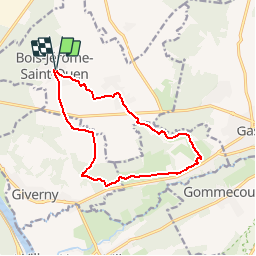
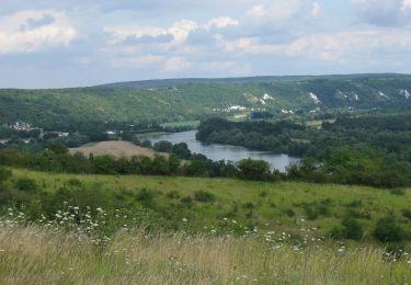
Randonnée Marche de 12 km à découvrir à Normandie, Eure, Bois-Jérôme-Saint-Ouen. Cette randonnée est proposée par marcel.F.

Description

boucle au départ de Bois Jérôme Saint Ouen vers Ste Geneviève les Gasny et retour par La Chapelle Saint Ouen

Profil altimétrique

Localisation

Pays :
France
Région :
Normandie
Département/Province :
Eure
Commune :
Bois-Jérôme-Saint-Ouen
Localité :
Unknown
Départ:(UTM)
393035 ; 5440086 (31U) N.

Randonnées à proximité

Randonnée Marche Giverny - 076-104-Giverny Matin 12km-526-030- - Photo
Marche
rvs147

Marche

Facile
(2)
Giverny, Normandie, Eure, France
9,2 km | 11,5 km-effort
2h 32min
Oui
Randonnée Marche Vernon - Les falaises de Seine de Vernon à Mantes la Jolie - Photo
Marche
chessyca

Marche

Difficile
Vernon, Normandie, Eure, France
37 km | 47 km-effort
7h 38min
Non
Randonnée A pied Gommecourt - Accès gr2 - Photo
A pied
PRO

A pied

Facile
Gommecourt, Île-de-France, Yvelines, France
5,6 km | 6,7 km-effort
1h 31min
Non
Randonnée Marche Giverny - Giverny Le lézard vert - Photo
Marche
Marie-Claire-mcp

Marche

Difficile
Giverny, Normandie, Eure, France
5,7 km | 7,5 km-effort
1h 57min
Non
Randonnée Marche Giverny - Giverny : les coteaux vers le Vexin 13 km - Photo
Marche
MichelRando7656

Marche

Très facile
Giverny, Normandie, Eure, France
14,7 km | 17,8 km-effort
4h 51min
Non
Randonnée Moteur Giverny - Giverny , les Coteaux avril 2019 - Photo
Moteur
MichelRando7656

Moteur

Moyen
Giverny, Normandie, Eure, France
13,6 km | 16,5 km-effort
3h 28min
Non
Randonnée Moteur Giverny - Giverny , les Coteaux avril 2019 - Photo
Moteur
MichelRando7656

Moteur

Moyen
Giverny, Normandie, Eure, France
13,6 km | 16,5 km-effort
3h 28min
Non
Randonnée Moteur Giverny - Giverny , les Coteaux avril 2019 - Photo
Moteur
MichelRando7656

Moteur

Moyen
Giverny, Normandie, Eure, France
13,6 km | 16,5 km-effort
3h 28min
Non
Randonnée V.T.T. Vernon - Les prés de Vernonnet - Vernon - Photo
V.T.T.
tracegps

V.T.T.

Facile
Vernon, Normandie, Eure, France
3,3 km | 3,7 km-effort
19min
Oui


Fermer
Mes abonnements