Randonnée Moto-cross Saint-Chély-d'Apcher - saint-chely saint martin - Photo
 frank12
frank12

Utilisateur

© OpenStreetMap contributors
Longueur
Longueur
102 km
Altitude max
Altitude max
1394 m
Dénivelé positif
Dénivelé positif
2621 m
Km-Effort
Km-Effort  
138 km
Altitude min
Altitude min
425 m
Dénivelé négatif
Dénivelé négatif
2994 m
Boucle
Boucle
Non
Date de création :
2019-05-05 10:01:35.252
Dernière modification :
2019-05-05 10:05:51.743

(1 Avis)

Moto-cross
Moto-cross
4h00
Difficulté : Facile

Scannez ce code QR pour ouvrir la randonnée dans l'application SityTrail

Application GPS de randonnée GRATUITE

Logo SityTrail SityTrail

IGN / Instituts géographiques

Télécharger SityTrail sur l'App Store Télécharger SityTrail sur Google Play

Logo SityTrail SityTrail World

Le monde est à vous

Télécharger SityTrail sur l'App Store Télécharger SityTrail sur Google Play Télécharger SityTrail sur Huawei AppGallery

À propos

Randonnée Moto-cross de 102 km à découvrir à Occitanie, Lozère, Saint-Chély-d'Apcher. Cette randonnée est proposée par frank12.

Profil altimétrique

Localisation

Pays :
France
Région :
Occitanie
Département/Province :
Lozère
Commune :
Saint-Chély-d'Apcher
Localité :
Unknown
Départ:(UTM)
521815 ; 4960552 (31T) N.

Commentaires

Veuillez vous connecter pour laisser un commentaire ou une note


Bonjour, je viens de voir votre rando et j'aimerai savoir avec quel type de moto vous l'avez faite ? Pour ma par j'ai une Africa Twin 1000CRF. Pensez vous que cette rando et les autres que vous avez publiées sont faisables avec mon trail ? Merci de votre réponse


Randonnées à proximité

Randonnée Marche Saint-Chély-d'Apcher - De St Chely d'Apcher à Aumont  Aubrac - Photo
Marche
tracegps

Marche

Difficile
Saint-Chély-d'Apcher, Occitanie, Lozère, France
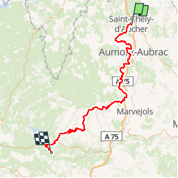
18,6 km | 24 km-effort
4h 15min
Non
Randonnée Moto-cross Saint-Chély-d'Apcher - saint-chely vimenet - Photo
Moto-cross
frank12

Moto-cross

Facile
Saint-Chély-d'Apcher, Occitanie, Lozère, France
109 km | 149 km-effort
Inconnu
Non
Randonnée Marche Saint-Chély-d'Apcher - Aubrac - 2° jour St Chély d'Apcher - Aumont Aubrac - Photo
Marche
jmp76700

Marche

Moyen
Saint-Chély-d'Apcher, Occitanie, Lozère, France
18,1 km | 24 km-effort
5h 9min
Non
Randonnée Moteur Les Bessons - Parcours quad 02 - Photo
Moteur
splanc

Moteur

Difficile
Les Bessons, Occitanie, Lozère, France
17,5 km | 22 km-effort
56min
Oui
Randonnée Moteur Les Bessons - Tour QUAD 001 - Photo
Moteur
splanc

Moteur

Moyen
Les Bessons, Occitanie, Lozère, France
16,2 km | 21 km-effort
Inconnu
Oui
Randonnée Marche Prunières - Aubrac2024-Apcher - Photo
Marche
raymondfn

Marche

Difficile
Prunières, Occitanie, Lozère, France
11,2 km | 14,9 km-effort
3h 23min
Oui
Randonnée V.T.T. Saint-Chély-d'Apcher - St chely d'apcher siniere  - Photo
V.T.T.
yvesdpt38

V.T.T.

Très difficile
Saint-Chély-d'Apcher, Occitanie, Lozère, France
38 km | 49 km-effort
3h 22min
Non
Randonnée Vélo électrique Saint-Chély-d'Apcher - 3_250423 - Photo
Vélo électrique
ricou1964

Vélo électrique

Difficile
Saint-Chély-d'Apcher, Occitanie, Lozère, France
40 km | 52 km-effort
5h 22min
Non
Randonnée Vélo de route Saint-Chély-d'Apcher - 14- St Chély d'Apcher - Mende - Photo
Vélo de route
v.hanosset

Vélo de route

Très difficile
Saint-Chély-d'Apcher, Occitanie, Lozère, France
49 km | 61 km-effort
3h 42min
Non


Fermer
Mes abonnements